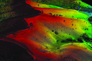
 The rugged terrain of inland São Paulo is shown in vibrant color for good reason. The landscape is not a photograph, but rather an image processed from clouds of points produced with a laser scanning technology known as Light Detection and Ranging (LIDAR). The equipment, deployed from an airplane, performs a sweep of the selected area and provides several pieces of information, including the volume of lumber, the amount of carbon and the profile of the native or planted forest. The technique – already employed as a source of data for scientific studies abroad as well as breaking new ground in the area of remote sensing – is being used for the first time by a team from the Luiz de Queiroz College of Agriculture at the University of São Paulo (Esalq-USP) in forestry studies and applications. This image depicts a plantation of eucalyptus on the left and pastureland on the right, separated by the ridge of rugged terrain. The image was captured and processed by Pollyanna Santos during a forestry engineering internship activity.
Image submitted by Luiz Carlos Estraviz Rodriguez, professor in the Forestry Sciences Department at Esalq-USP.
If you have an image related to research, send it to: imagempesquisa@fapesp.br, resolution 300 dpi (width: 15 cm) or at least 5 MB. Your work may be selected by the magazine.
Republish