
In agriculture, drones distribute seeds or fertilizers with precision, saving both time and money. When combined with sensors and artificial intelligence, they can perform remote sensing, similar to satellites and airplanes, monitor large crops, conduct detailed analyses of soil’s chemical elements, and identify issues such as erosion. One of the most advanced techniques in this field, Synthetic Aperture Radar (SAR), has been enhanced by Radaz, a startup founded in 2017 at the University of Campinas (UNICAMP) and now based in São José dos Campos, São Paulo.
“It’s an innovative technology with enormous potential to generate a wide variety of products, serving various market segments,” says electrical engineer Hugo Enrique Hernández Figueroa from UNICAMP’s School of Electrical and Computer Engineering (FEEC), who led the team responsible for developing a radar mounted on a small drone. To achieve this, the team had to miniaturize the radar’s electronic hardware and antennas. The idea behind SAR, explains the researcher, involves using a moving radar to simulate an antenna significantly larger than the radar’s physical components. As the antenna’s directivity increases with its size, the system’s resolution also improves.
Through its antenna, the radar emits pulsed electromagnetic waves that are reflected by obstacles on the ground. These waves are then detected by the antenna while the radar is in motion, whether on an airplane, satellite, or drone. The movement of the radar along its trajectory creates a large virtual antenna, allowing for high resolutions and precise observations.
The operating principle of SAR is similar to that of interferometry, where the combination of multiple radio antennas simulates a single large antenna corresponding to the path traveled. If the drone moves 100 meters (m) in a straight line, the SAR can simulate a 100-meter aperture antenna; if the trajectory is circular, with a radius of 300 meters, the radar will simulate a spiral-shaped antenna with a 300-meter radius.
Developed in the United States in the 1950s and used in satellites and space probes since the 1960s, Synthetic Aperture Radar (SAR) has been employed to map the terrain of Venus, which is obscured by clouds made of microscopic drops of sulfuric acid and other aerosols. In the early 2000s, SAR was integrated into large drones for military purposes. With the growing miniaturization of electronic components and the proliferation of drones, it became apparent that SAR systems could be attached to small, civilian devices.
“The challenge was to do it, and nobody was doing it,” says Figueroa. The first recorded instance of SAR on a drone dates back to 2016, from the University of Texas, United States, but this version was handmade and produced low-quality images. The São Paulo-based company took a different approach, developing a system with three spectral bands, including an advanced inertial navigation system (see infographic).

Working with his team, the UNICAMP researcher focused on reducing the size of a 100-kilogram (kg) device, which had only been usable in airplanes, to one weighing 5 kg that could fit on small drones. Electronic engineer Laila Moreira, technical director of Radaz and a key contributor to the device’s development at UNICAMP, notes that another critical modification was the incorporation of computer programs designed for processing and interpreting the images, based on artificial neural networks.
FAPESP’s support through the Innovative Research in Small Businesses (PIPE) program helped transform the prototype, completed in 2017, into a commercial device. The first results from monitoring eucalyptus and sugarcane crops were published in February and April 2020 in the journal Remote Sensing.
The drone primarily follows two flight paths: linear, in a single direction, and helical, in the form of a downward spiral, simulating a parabolic antenna to enhance the radar’s resolution. The pulses emitted by the radar along the helical path and reflected by different underground structures provide precise data about the subsoil. This information is processed using the back-projection algorithm, commonly used in CT scans, which reconstructs the reflected pulses into three-dimensional images.
The device is equipped with three antennas, each operating on a different band. The C-band collects information about the top of the vegetation and provides data on plant growth. The L-band penetrates beneath the treetops to measure the volume of a crop or, in helical flight, to capture data about the soil. The P-band penetrates the soil, extracting information up to 50 cm deep in linear flight and up to 100 m in helical flight. According to Radaz, no other device in the world has this configuration.
In a field test conducted in 2022, the P-band successfully detected leaf-cutter ant nests in eucalyptus and pine crops owned by paper manufacturer Klabin in Paraná. The equipment identified 29 previously unknown anthills, with areas ranging from 1 to 100 square meters (m²), in a eucalyptus crop in Ortigueira, Paraná. The device showed that the ant nests were located at depths of up to 7 meters, as detailed in a preprint article submitted to the arXiv repository in December 2024.
“This was the world’s first record of an anthill underground using this technology,” said Bruno Afonso Magro, Klabin’s forestry research and development manager, in an interview with Agência FAPESP in July 2022. Typically monitored through area sampling and human intervention, leaf-cutter ants create nests that can reduce productivity by up to 15%.
In another test, also published in December on arXiv, the equipment successfully identified the height and growth stage of 340 sugarcane seedlings planted in a 20,000 m² experimental area at UNICAMP’s School of Agricultural Engineering (FEAGRI). A report presented at a congress in Athens, Greece, in 2024, showed that the device achieved 100% accuracy in locating cow and pig carcasses buried 1.5 meters underground. The device also records soil subsidence, erosion, and humidity.

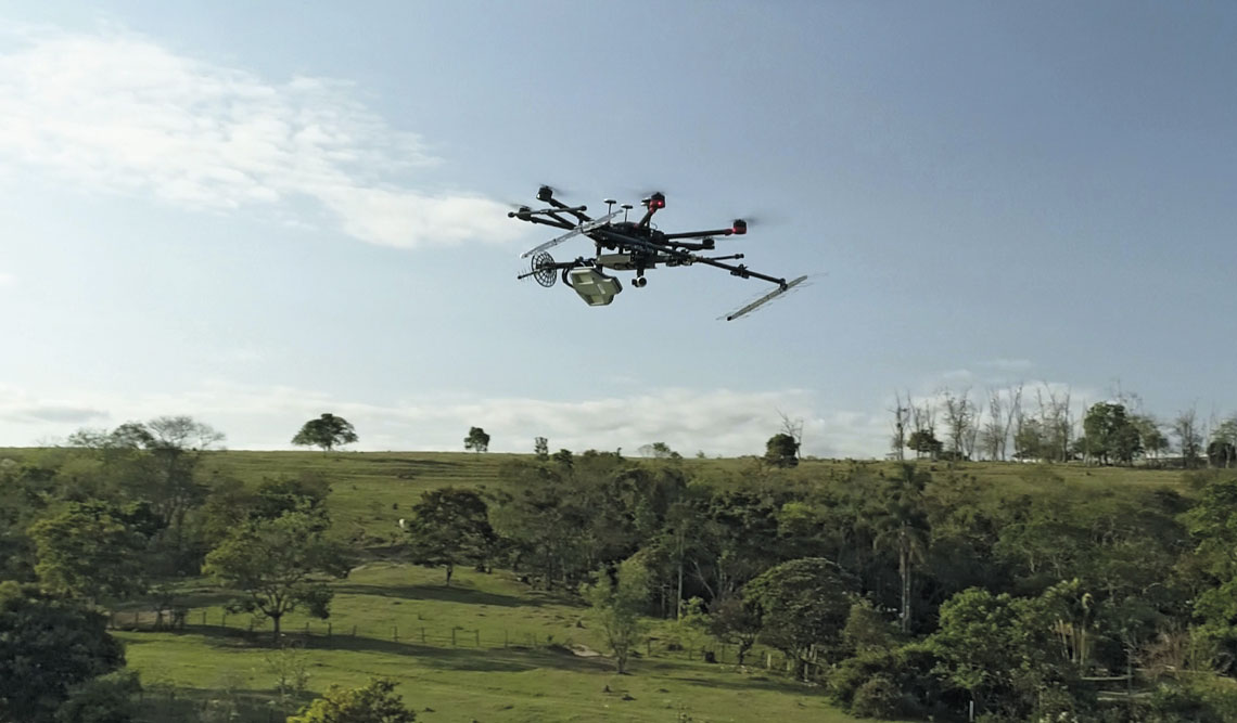
Radaz publicityClose-up of the device attached to the drone (on the right) and the radar being tested in the startup’s laboratoriesRadaz publicity
Foreign demand
The Radaz system has also been successfully used to monitor the growth of sugarcane on a farm in São Paulo and to locate iron ore deposits, according to electronic engineer Fernando Ikedo, Radaz’s commercial director. Due to contractual stipulations, the names of the clients cannot be disclosed.
The market for remote sensing with drones appears to have significant growth potential. According to Ikedo, the startup’s revenue increased from R$1.1 million in 2022 to R$5.1 million the following year. In 2024, it reached R$17.3 million, with most of the revenue coming from international sales.
One of the clients is physicist Henrik Persson from the Swedish University of Agricultural Sciences, who uses the radar-equipped drone to assess the biomass and metabolism of trees, soil moisture, water tables, and underground rock layers. “The tomographic measurements have enabled new research into soil conditions, usually done by taking samples, which is expensive, tedious, and time-consuming,” Pesquisa FAPESP reported.
The British company Surveyar acquired the innovation to map beaver dams, which cause losses to farmers by damming up waterways that flood crops. According to the company’s director, William Kirk—who discovered Radaz while reading articles by Brazilian researchers on anthill detection—the experiment was successful and led to the use of the technology for detecting soil and vegetation moisture, monitoring soil deformation, measuring biomass, and identifying buried objects.
Challenges ahead
With no similar equipment available on the domestic market, the new technology faces the challenge of exploring new markets. Given the cost of the electronic components and the advanced technology involved, the complete equipment is sold for no less than R$1 million, excluding the cost of the drone. There are also other complementary technologies that are more affordable and meet the specific needs of rural farmers, though none offer the same capabilities as the Radaz device.
Depending on the objective, crop monitoring can be conducted with simple conventional cameras, such as RGB cameras, which capture only the visible spectrum and are priced between R$12,000 and R$60,000. Multispectral cameras, which cover other frequencies such as infrared, can cost up to US$300,000 (around R$1.6 million). Devices of this type can provide satisfactory data on plant growth, biomass, and health status, according to environmental engineer Lucas Osco from the University of Western São Paulo (UNOESTE) and the Instrumentation unit of the Brazilian Agricultural Research Corporation (EMBRAPA) in São Carlos, who works with remote sensing.
Another alternative, according to Osco, is Lidar technology (light detection and ranging), which uses laser beams instead of radar signals. With prices starting at R$100,000 and reaching up to R$1 million, it offers detailed three-dimensional mapping but has visibility limitations, leaving room for the use of SAR.
Innovative technology aimed at the field also face challenges related to regulation and operator training. Additionally, there is resistance from Brazilian farmers, who, in the recent past, have seen results below expectations from drones that promised to increase production. “Farmers opt for technologies that are already established, with high and guaranteed returns. This makes it difficult to sell innovative products,” notes agricultural engineer José Marques Júnior, from São Paulo State University (UNESP), Jaboticabal campus, a specialist in soil analysis (see Pesquisa FAPESP issue nº 336).
The story above was published with the title “In-depth field insight” in issue in issue 349 of march/2025.
Projects
1. Remote sensing radar carried by a drone (nº 19/22222-1); Grant Mechanism Innovative Research in Small Businesses (PIPE); Principal Investigator Dieter Lubeck (Radaz); Investment R$902,269.23.
2. Strongly resonant fully dielectric metasurfaces based on quasi-dark and toroidal modes (nº 21/06506-0); Grant Mechanism Regular Research Grant; Cooperation Agreement Consiglio Nazionale delle Ricerche (CNR), Italy; Principal Investigator Hugo Enrique Hernández Figueroa (UNICAMP); Investment R$225,357.66.
Scientific articles
LUEBECK, D. et al. Drone-borne differential SAR interferometry. Remote Sensing. Vol. 12, no. 5, 778. Feb. 29, 2020.
ORÉ, G. et al. Crop growth monitoring with drone-borne DInSAR. Remote Sensing. Vol. 12, no. 4, 615. Feb. 12, 2020.
ORÉ, G. et al. Predicting sugarcane harvest date and productivity with a drone-borne tri-band SAR. Remote Sensing. Vol. 14, no. 7, 1734. Apr. 4, 2022.
ORÉ, G. et al. Soil moisture estimation of bare and vegetation-covered areas using a P/L/C-band SAR. ArXiv. Dec. 16, 2024.
ORÉ, G. et al. Ant nest detection using underground P-band TomoSAR. ArXiv. Dec. 16, 2024.
ORÉ, G. et al. Locating buried bodies using SAR tomography. IEEE International Geoscience and Remote Sensing Symposium. July 7–12, 2024, Athens.