

NasaMap of the surface of Mars, with the region analyzed (highlighted)…Nasa
Mars may be uninhabited, but it is far from a tranquil place. Its surface is often swept by powerful whirlwinds, called dust devils, that reach sizes up to 100 times greater than those recorded on Earth. On Mars, they reach radii of 2 km and heights of 20 km. Visible from the planet’s orbit, they leave kilometer-long tracks behind them and shape the Martian landscape.
Until now, researchers interested in studying the phenomenon have been forced, in most cases, to look for dust devil tracks by examining images of the Martian surface manually, one-by-one. But a new method, developed by Brazilian and Portuguese researchers, promises to facilitate research by allowing automatic detection of both the tracks and other characteristics of dust devils. The method is already 92% accurate and continues to be improved.
After Earth, Mars is the best-studied planet in history. Fifteen space probes have already visited the planet, either by flying by it or by orbiting it. “A single camera, on a single probe, produces up to 2,000 images of each region of Mars,” says cartographic engineer Thiago Statella, professor at the Federal Institute of Education, Science and Technology of Mato Grosso, Cuiabá Campus. Statella worked under the guidance of cartographic engineer Erivaldo Antônio da Silva, of São Paulo State University (Unesp) in Presidente Prudente, and Pedro Pina, of the Superior Technical Institute (IST), University of Lisbon, to develop a program to automatically detect dust devil tracks.
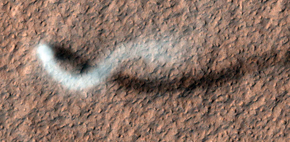
Nasa… and dust devil observed in 2012 by the camera on the Mars Reconnaissance OrbiterNasa
The program uses mathematical morphology tools, a digital processing technique that extracts information from images, in this case taken by cameras aboard the orbiting probes Mars Global Surveyor (MGS) and Mars Reconnaissance Orbiter (MRO). Developed in France in the 1960s by mathematicians Georges Matheron and Jean Serra, mathematical morphology was used initially to extract information from microscopic images of rocks and metals through analysis of their geometric structures. Gradually, its use was extrapolated to other areas until it reached cartography. Today it helps identify structures on other planets, a field known as planetary cartography. “Our group had already been using mathematical morphology in mapping studies of the Earth’s surface, which was uncommon at first. That’s what sparked the interest of researchers from Portugal in collaborating,” says Silva.
Image processing based on mathematical morphology allows us to manipulate the hue of the pixels and, thus, highlight or eliminate certain characteristics in the image. This strategy allows us to remove features that do not interest us—such as valleys, rocks, dunes and shadows—from the image, leaving just dust devil tracks. The result is a light image on a dark background that hides the other characteristics of the original image.
The researchers used the technique to treat 200 images of five regions on Mars captured by the MGS and MRO probes and compared the results with the visual analysis of an expert. The program’s accuracy varied from 69% to 99%, depending on the image. The average was 92%.
The windy side
The detection of tracks can also provide information on how the planet’s atmosphere functions. Dust devils are formed by the movement of gases in the Martian atmosphere. Sunlight striking the ground heats the gas near the surface, which rises and pushes the upper layers of the atmosphere upwards. As they rise, these layers cool down and move downwards, generating a continuous movement known as a convection cell. Gusts of wind may shift the hot air horizontally and change the direction of the convection cell, forming dust devils. For this reason, their tracks can store information about the direction in which the wind was blowing at the time they were formed.
 This information is important for improving the general circulation model (GCM) for Mars, which the US space agency, NASA, has been working on since the 1960s in order to describe the operation of the planet’s atmosphere and its influence on climate. Currently the GCM is able to predict the expected behavior of wind in the different Martian regions.
Statella, Silva and Pina have also developed a program that calculates the wind’s preferred direction from the tracks detected in the image. The results obtained using this strategy were similar to those of an analysis performed manually and those in the GCM according to a study published in the journal Advances in Space Research in 2014.
“One way to assess GCM predictions is through the observations made by the probes that landed on the planet. But these observations are often not systematic,” says Statella. “Automatic detection of the direction of dust devils can provide global information on the wind direction in a region.”
This strategy, however, provides only the predominant wind direction—that of the largest number of tracks. The problem is that a single image can show tracks with more than one orientation, generated by dust devils that swept the region at different times, under different wind regimes.
Statella tested three approaches to estimate the predominant wind direction in 190 images taken by the MGS and the MRO. The most effective had an accuracy of 86.3% when compared to an analysis prepared by an expert. Statella’s approach coincided in every case with the forecasts made by the GCM for different periods in the region known as Argyre in the Martian southern hemisphere. He now intends to develop a database with the greatest number of dust devil records possible in order to determine which types are the most common in different regions of the planet and in which periods they tend to occur.

MIRIAM PEDROSA
Mercury: craters detected correctly (green); erroneously (red) and not detected (blue) MIRIAM PEDROSAMessenger from Mercury
Silva and Pina’s team also uses mathematical morphology tools and other image processing techniques to identify craters on Mercury, the closest planet to the Sun. Miriam Pedrosa, a PhD student at Unesp, has been developing a program to analyze images taken by the Messenger probe. The probe took the first images of Mercury’s surface in overflights in 2008 and 2009. Since entering the planet’s orbit in 2011 it continues to send images, but with a higher resolution.
During her master’s degree under the guidance of Silva, Pedrosa developed a program for the automatic detection of craters in images of Mars. For Mercury, the program was enhanced because of the lower spatial resolution of the images obtained by Messenger. “Several probes have visited Mars. So images with great resolution are available, and in some of them each pixel represents an area measuring 25 square centimeters,” explains Pedrosa. “In the case of Mercury, the best resolution available is around 16 meters and, in some cases, no more than 250 meters.” This means that a crater measuring 100 meters in diameter could disappear in a photo. In addition to the resolution, surface features of the planet, its proximity to the Sun and the quality of the cameras’ detectors also hinder the use of the program.
Pedrosa has already analyzed 47 images of three regions of the planet: the Mozart, Rachmaninoff and Raditladi basins. The average degree of accuracy in the identification of craters was 87% compared with identification performed by an expert. “The program uses images with very different quality and resolution characteristics,” says Pedrosa. “The best results were obtained with photos with higher resolution.”
In the case of Mercury, however, there were a significant number of false positives—features that the program mistakenly classified as craters. In order to solve the problem, she included in the method a phase identifying features that, although they look like craters, are not. “This is a new trend in automatic detection, providing the classifier with examples of features that are present in the analyzed image and are not craters,” she says. “In this way, the program will ‘learn’ to discriminate, until it becomes able to perform the analysis on photos with very different characteristics,” she explains.
Few groups in Brazil work with planetary cartography. Brazil will host the next conference of the International Cartographic Association in August 2015, with a session on the topic. The Unesp group is one of the few that apply mathematical morphology to studies in the area. “We have obtained some interesting results,” says Silva. “Most researchers search for craters with a radius greater than 1 km. We can detect craters with these dimensions and are working to detect even smaller craters.”
Project
Development of a methodology for the extraction of cartographic features from digital images of the surfaces of the planets Earth, Mars and Mercury (No. 2014/08822-2); Grant Mechanism Regular Line of Research Project Award; Principal investigator Erivaldo Antonio da Silva (Unesp); Investment R$60,850.00 (FAPESP).
Scientific articles
STATELLA, T.; PINA, P.; SILVA, E. A. Automated determination of the orientation of dust devil tracks in Mars Orbiter Images. Advances in Space Research. V. 53, p. 1822-33. 2014.
STATELLA, T.; PINA, P.; SILVA, E. A. Image processing algorithm for the identification of Martian dust devil tracks in MOC and HiRISE images. Planetary and Space Science. V. 70, p. 46-58. 2012.