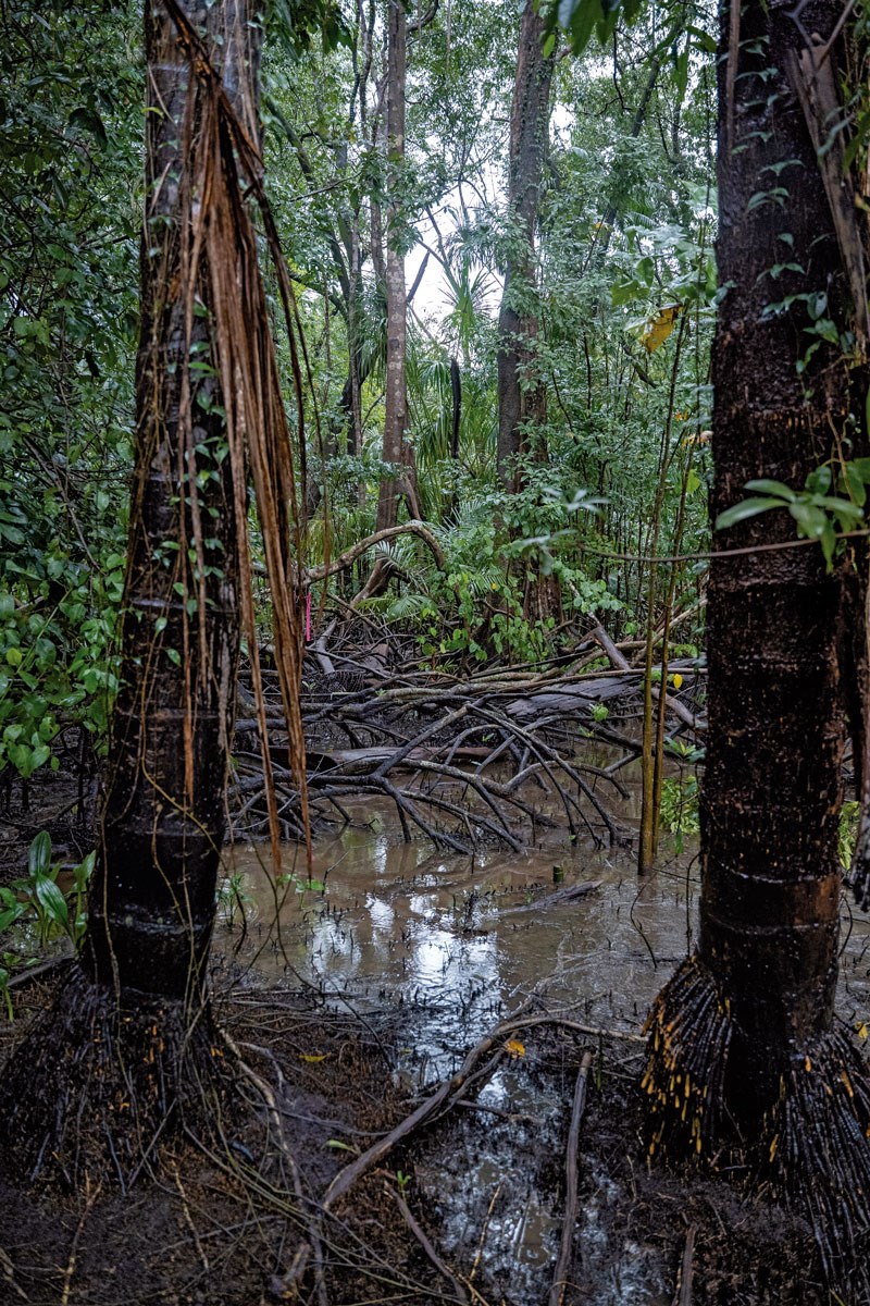
Corey Robinson / National GeographicA mangrove in Amazonas: the plants are a mixture of species from two environmentsCorey Robinson / National Geographic
A new study estimates that the area of mangroves surrounding the mouth of the Amazon River, on the border between the states of Pará and Amapá, is at least 180 square kilometers (km2) larger than is known. According to an article published in August in the scientific journal Current Biology, the total extent of this type of transitional vegetation between land and marine environment reaches 1,713 km2 at the vast mouth of the river, equivalent to around 15% of Brazilian mangroves. The plants present in the region are unique: they are a mixture of species adapted to freshwater environments, such as floodplains, with those of typical mangroves, where salinity is high.
On the muddy soil of the so-called Amazon delta, a type of mouth formed by several channels and small islands, forests were found with herbaceous species such as aninga (Montrichardia linifera), accompanied by typical trees of floodplains that appear outside the normal habitat, such as corticeira trees (Erythrina crista-galli) and some types of palm trees, including açaí (Euterpe oleracea) and buriti (Mauritia flexuosa). Mangroves are normally dominated by trees adapted to salt water and brackish environments. “But the Amazon dumps so much fresh water into the Atlantic that the salinity is almost zero in its delta and for dozens of kilometers along the coast in a northerly direction,” says oceanographer Angelo Bernardino, of the Federal University of Espírito Santo (UFES), lead author of the article, alongside Brazilian, US, Australian, and Scottish colleagues.
By definition, mangroves are a type of coastal ecosystem found in tropical and subtropical areas. They are characterized by plant species that have adapted to tolerate the presence of sea water. Their trees resist high salt concentrations and can surpass 35 meters (m) in height. The size is a response to the strength of the tides and also to the renewal of nutrients by the local dynamic: as the water coming from the ocean can reach depths of up to 10 m, the plants need to be large and have equally robust roots that emerge from the soil and help secure the impact. Due to the action of the salt water, trees with low tolerance to salt do not resist over time, and the environment is overtaken by species of mangrove.
But this is not what happens in some neighboring areas to the sea mouth of certain rivers. The existence of mangroves with freshwater plants is due to the pattern of rainfall and the influence of the mouth of a large river on parts of a coastal area. “In the dry season, with reduced flow rates of the rivers, the salt water penetrates the mangroves more,” explains oceanographer Mário Soares, coordinator of the Mangrove Study Center at Rio de Janeiro State University (NEMA-UERJ). “In the rainy season, there is a greater presence of fresh water. This prevents the environment being dominated by saltwater plant species.” According to Soares, who did not participate in the study about the Amazon delta, but has done research in the region for years, the mangroves located on the border of the state of Pará with Amapá are different than what is seen in the majority of Brazil.
Monitoring the influence of the sediment transported by the Amazon, the so-called river plume, at different points of its mouth, was the objective of an expedition headed by Bernardino in April this year. The trip is part of the Perpetual Planet Amazon Expedition, of the National Geographic Society, which promotes scientific excursions to the Amazon basin, from the region of the Andes to the Atlantic. The team coordinated by the researcher from UFES explored 11 mangrove forests along the Amazon delta and collected data on the water, soil, salinity, plant composition of the forests, and carbon stocks of the ecosystems.
Besides noting the presence of freshwater species that theoretically should not be in the mangroves, the expedition discovered something interesting. On the first stop, near the community of the archipelago of Bailique, a five-hour boat trip from Macapá, the state capital of Amapá, the soil had extremely low salinity, close to zero parts per thousand (‰). “The Amazon is the largest river in the world in terms of water volume. There is no other place with so much sediment arriving at the mangroves on the coast,” says Bernardino. It is estimated that close to the island of Marajó, on the coast of Pará, 3 million liters of water from the Amazon reach the ocean every second. This total represents almost 20% of the water that drains into the sea from all the rivers on Earth. The mass of sediment accumulated in a one-month period, starting from the Andes, is equivalent to the weight of Sugarloaf Mountain, in Rio de Janeiro.
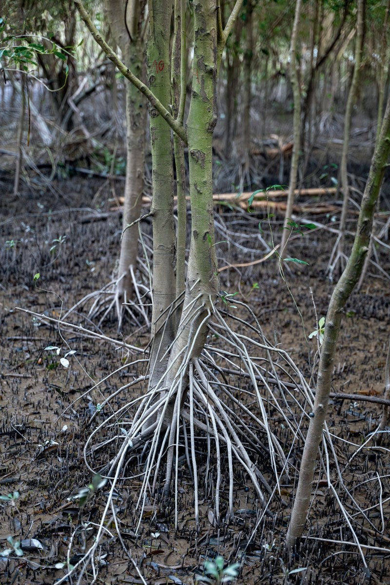
Corey Robinson / National GeographicThe deep roots help protect the mangroves from the action of the tideCorey Robinson / National Geographic
Although less dominant, the influence of the Amazon plume was still present around 100 km to the north of the archipelago of Bailique, in the area surrounding Sucuriju, one of the corners of the state of Amapá. Due to the greater presence of water from the Atlantic, the salinity in this stretch was between 5‰ and 11‰, seven to three times lower than the average rate for an area of ocean. As a result of the low salinity, the soils in these mangroves in the Amazon delta are also very acidic, contrary to what is usually found in the rest of Brazil.
Geologist Valdenira Santos, of the Aquatic Research Center of the Institute for Scientific and Technological Research of the State of Amapá (IEPA), says that areas of mangroves were mapped composed of only trees of the species popularly known as siriúba (Avicennia germinans), also present at the mouth of the Amazon, more than 230 kilometers further inland from the mouth of the river. Siriúba is a typical tree species of classic mangroves, where salinity is high. In principle, it should not occur in regions far from the salt water of the Atlantic. It is a situation different to the one described in the article by Bernardino, but illustrates the spread of this type of ecosystem in unexpected locations. “We don’t yet know the mechanisms that make these mangrove populations establish themselves in zones with a complete lack of seawater influence,” comments Santos.
Besides hosting plant species and being home to many animal species, such as birds, crabs, and fish, the mangroves also have an important role in the sequestration of carbon dioxide (CO2), the main atmospheric greenhouse gas. Because they are poor in oxygen, the muddy soils of the mangroves do not encourage the decomposition of the organic material they store. Parts of plants and trees which would normally rot in other environments and release CO2 back into the atmosphere remain preserved at the bottom of these coastal ecosystems. In practice, mangroves act as carbon sinks.
This process is probably even more intense in the northern part of the Brazilian coast under the influence of the Amazon plume. The river sediment transported to the sea carries a large amount of organic matter. Therefore, analysis of the evolution of the quantity of carbon stored in the soil of the mangroves in the Amazon delta may serve as a thermometer of human activities in the river basin. Part of the organic waste produced by deforestation and by the introduction of farming activities ends up in the region’s mangroves, where it remains preserved. Measuring the levels of carbon accumulated in the trees and soil of mangroves, says Bernardino, could be an indicator of the advance of phenomena such as deforestation in the last decades.
According to the edition released in September this year of a report on the global mangrove situation, compiled by a group of environmental nongovernmental agencies that take part in the Global Mangrove Alliance, the area of the planet covered by this ecosystem has reduced by 5,245 km2 (3.4% of the total) since 1996. However, the work suggests that the areas of mangrove with greatest growth over the past years are located in river mouths, such as the Indragiri, in Sumatra, the Amacura, in Venezuela, and especially the Amazon. The good news could hide a worrying figure: the area of mangroves may have increased in these coastal regions due to the intensification of deforestation. According to the report, this would mean that the rivers were carrying more sediment to their mouth, increasing the stretches of coastline able to be occupied by these ecosystems. Another possible explanation: the increased size of the mangroves could be due to the improvement in the techniques for mapping these formations.
This situation, allied with a rise in global sea level due to climate change, could also cause the mangroves to move inland. An article by researchers from Europe and Brazil, published in May 2022 in the journal Science of the Total Environment, analyzed satellite imagery and identified an increase of 157 km2 in the area of mangroves over the past 38 years on the coast of Amapá alone. According to the work, the growth is probably due to the increased level of the oceans, which would have pushed this type of coastal ecosystem inland.
Scientific articles
BERNARDINO, A. F. et al. The novel mangrove environment and composition of the Amazon Delta. Current Biology. Vol. 32, no. 16. aug. 22, 2022.
VISSCHERS, L. L. B et al. Accelerated migration of mangroves indicate large-scale saltwater intrusion in Amazon coastal wetlands. Science of the Total Environment. may 3, 2022.