
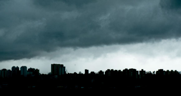
léo ramosBetween 1933 and 2010, the annual total rainfall increased by 425 mm in the metropolitan region, according to data from USPléo ramos
The land of drizzle has become the megalopolis of storms. Over the last 80 years the annual amount of rain that falls on the Metropolitan Region of São Paulo, where one in every ten Brazilians lives in an area equivalent to almost 1% of the national territory, has increased by 425 millimeters (mm), half of what it rains in a good part of the semi-arid part of Brazil. It has jumped from an annual average of almost 1,200 mm in the 1930s to something around 1,600 mm in 2000. Calculated on a linear basis it is as if every year it had rained 5.5 mm more than in the previous 12 months. The rainfall has not just intensified, it has changed its pattern. It is not simply raining a little more every day, an effect that would be hardly perceptible in practice and incapable of causing constant flooding in the region. The number of days with heavy or moderate rain has increased and this is causing storms in the winter too, a period that was normally dry. On the other hand, the number of days when there is only light rain (less than 5 mm) has reduced.
A pendulous regime of extremes has started dominating the rainfall cycle in the metropolitan region: when it rains, it generally rains a lot. But between the days of great humidity there might be long periods of drought. The Greater São Paulo area seems to be moving towards the worst of both worlds; alternating intense periods of excessive rain and a lack of rain all throughout the year. “Urbanization and the so-called heat island effect, in addition to atmospheric pollution, seem to play an important role in altering the rainfall pattern in São Paulo, especially in the already normally wet seasons, such as the spring and summer,” says Maria Assunção da Silva Dias, from the Institute of Astronomy, Geophysics and Atmospheric Sciences of the University of São Paulo (IAG-USP), author of an as-yet unpublished study on the topic. “In the drier months the influence of global climate change is responsible for 85% of the dynamics involved in the increase in extreme rainfall.” Although less clear, this same tendency towards an increase in the number of days with heavy rain was detected in the Metropolitan Region of Rio de Janeiro.

The new pluviometric pattern in São Paulo is not like a passing cold front. It’s here to stay, according to models produced by the Terrestrial System Science Center at the National Institute of Space Research (CCST-Inpe). The projections suggest that the current situation is a type of prologue of the future story. They signal that by the end of this century there is likely to be an increase in the number of days with rainfall over 10, 20, 30 and 50 mm, i.e. practically in all significant rainfall bands. There will be just a decrease in the number of days with very light rainfall and possibly an increase in the number of dry days. “The seasonality of the rains is also likely to change,” says José Marengo, head of the CCST, coordinator of a work on the rainfall projections in the metropolitan region that has not yet been published. “The number of storms outside the normally rainy season is likely to increase, the type of situation that catches the population by surprise.” Simulations take into account only the possible effects on the rainfall regime in the metropolitan region caused by the so-called global climate change, above all the increase in greenhouse gas concentrations that heat the air temperature. The weight that urbanization and air pollution may have on rains in Greater São Paulo has not been considered in the projections.
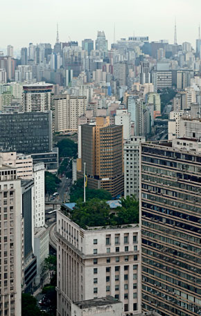
léo ramosFew patches of green in the metropolis of concrete and asphalt: if 25% of the territory of the Greater São Paulo area were covered by trees, the average temperature would fall by as much as 2.5ºCléo ramos
One of the great difficulties in making major studies that are capable of revealing climate fluctuations in the past and serving as a pointer for future projections is the absence of a series of long and reliable historical data, with daily information about the incidence of rain. Without them it is impossible to carry out a robust statistical analysis and have a clear view about how much it used to rain and how rainfall was distributed over the years and climatic seasons (spring, summer, autumn and winter). The specialists are unanimous in pointing out this deficiency in Brazil. The series with the best quality data about rainfall at a given point in the national territory is supplied by the meteorological station of the IAG, which is in the Parque do Estado [State Park] in Água Funda, in the south of the city of São Paulo. The records started in 1933, when the unit was inaugurated, and have continued until today.
Another factor gives the data supplied by the IAG’s meteorological station a unique character. The records were obtained in a major green area in the city São Paulo, the profile of which has not changed radically over almost 80 years, a rarity in a megalopolis that has few parks and gardens. In other words, although in the last century the city underwent a process of urbanization, with the soil being made impermeable, the natural conditions surrounding the station in the Parque do Estado have not changed radically. Therefore, it makes sense to compare the present data with those from the past since the local environment is more or less the same. “In the north of São Paulo, at the Santana Lookout Point, there is a meteorological station with measurements form the 1950s,” says Pedro Leite da Silva Dias, a researcher from IAG-USP and director of the National Laboratory of Scientific Computing (LNCC) in Rio de Janeiro, and also the author of a study on the evolution of rainfall in the metropolitan region. “But some decades ago there was just forest and today there’s a building right alongside the station.”
Due to the wealth of data supplied by the IAG’s station in the Parque do Estado, Assunção and her collaborators have been able to see more subtle details and trends in the rainfall regime over the last eight decades. Between 1935 and 1944 it rained on average more than 40 mm on around 30 days, with a great concentration of rainfall in the summer months, and on a lesser scale in the spring and autumn. During the period there were no records of episodes of rainfall of this intensity in the winter months. The situation began to change in the mid-1940s. Since then in every decade, there has been on average at least one rainstorm of this intensity in the winter. Between 2000 and 2009, there were about 70 days with storms over 40 mm. A similar tendency is repeated when the occurrence of daily rains over 60mm and 80mm is analyzed decade by decade.
 Generally speaking, two main factors can be related to the alteration in the rainfall regime in the metropolitan region: global climate change, a large scale phenomenon, and the heat island effect, which is localized and typical of megacities. The two operate in conjunction. One boosts the effects of the other and in general it is difficult to draw a dividing line between the two. According to Marengo, most of the climate models indicate that there will be an increase in the amount of rain from the River Plate basin to the southeast of Brazil over the next few decades. Within this broader framework the specific question arises about the weather in large cities, especially the heat island effect which, by making extremely urbanized areas hotter, also functions like a magnet for rain.
A moister sea breeze
The surface temperature of the Atlantic ocean on the coast of São Paulo State rose by almost one degree between 1950 and 2010. It went from 21.5°C to 22.5°C. It may not seem much, but one of the consequences of this warming is to increase the rate of water evaporation from the ocean, which is fuel that makes the sea breeze even more loaded with moisture. This process has repercussions on the weather over the coastal range of hills (Serra do Mar) and on the plain where the metropolitan region is located.
Why does much of the rain that falls on the Greater São Paulo region occur between the middle and end of the afternoon, after 3 p.m. or 4 p.m.? This is when the sea breeze, which is hot and moist as it comes off the Santista Coastal Plain, stops rising over the hills and reaches the megalopolis. “The south area of the city is generally the first place in the capital that feels the effects of the breeze,” comments Maria Assunção. The internal structure of cities, with lots of tall buildings, alters the direction of the winds and may even cause the sea breeze to rise at certain points in the metropolitan region and favor the formation of local rain clouds. Urban pollution, above all aerosols, can both favor as well as inhibit the occurrence of storms over cities, depending on their quantity.
 Studies carried out in the United States in the 1990s suggest that part of the increase in rainfall in some metropolitan regions, like Saint Louis, is due to its growing urbanization. In this area of the state of Missouri, where some 2.9 million people live, the rains have increased by between 5% and 25% over the last few decades. A study carried out last year in major cities in India concludes that changes in the rainfall regime in these urban concentrations derive more from natural fluctuations in the weather than from local phenomena.
Mitigation strategies
In the case of the São Paulo Metropolitan Region the work of USP encountered a strong correlation between its urbanization process and alterations in the rainfall regime. The episodes of extreme rains, of more than 40 mm, are increasing as the population of São Paulo and its neighboring cities grows and the territories of these municipalities become practically one huge urban sprawl, with little green, a lot of asphalt and full of sources of pollution and heat. From 1940 to 2010, the population of the metropolitan region increased ten-fold, from 2 million to 20 million inhabitants. The urban sprawl grew 12 times between 1930 and 2002, from 200 to 2,400 sq.km. The average annual temperature of São Paulo went up 3°C between 1933 and 2009, according to the records of the IAG’s station in the Parque do Estado, and the total rainfall increased by a third. “We used to study this process in a theoretical way before,” says Pedro Leite da Silva Dias. “Now we have more data, including digital sources.”
Mitigating the effect of heat islands may be a way of reducing episodes of extreme rain in urban centers. Physicist Edmilson Dias de Freitas, from the IAG-USP, has tested some measures in computer simulations to get an idea of their impact on the climate of the São Paulo Metropolitan Region. Painting the surfaces of houses and buildings white would not be an effective procedure. “The pollution of meteorological events quickly darkens the white in São Paulo,” says Freitas. “There’s no way of maintaining this.” The most effective measure would be to increase the city’s vegetation cover. According to the simulations, if 25% of the metropolitan region’s area were covered with trees, the average temperature could be reduced by between 1.5°C and 2.5°C. A more amenable climate would reduce the heat island effect and would perhaps not attract so much rain to the region. Green areas represent less than 10% of the Greater São Paulo area today.
 Indirectly, if there more parks and fewer areas impermeable to rain in the biggest Brazilian metropolis, the most perverse effect of the storms would also be minimized: intense rain would produce fewer floods. Exposed soil absorbs more of the rain that falls on it. “São Paulo violates a basic principle of drainage: rainwater has to filter into the soil where it falls,” says civil engineer, Denise Duarte, a professor at the School of Architecture and Urbanism of USP, who collaborates with colleagues from the IAG. “Here, with a large part of the city impermeable, the water is simply channeled away.” The rain from one place is transferred to other places, which are generally located at low points in the urban sprawl.
The current figure of approximately 1,600 mm annually of rain recorded in the IAG’s station functions as a generic reference for the current rainfall regime in the metropolitan region. In an area that today extends over 8,000 sq.km. and includes the territories of 39 municipalities, the amount of rain really measured year by year in each meteorological station may vary a lot. Work by the CCST traces a type of geographic distribution of rainfall in the Greater São Paulo area from historical data, with the daily total rainfall being supplied by 94 meteorological stations of the Department of Waters and Energy (DAEE) in the State of São Paulo and the National Waters Agency (ANA). Data for a 25-year period, between 1973 and 1997, were used in the work.
In the wettest areas, which are generally dotted with hills and mountains, annual rainfall may reach 2,400 mm, an amount of rain similar to that of the Amazon rainforest. Such is the case with that part of the Greater São Paulo area that is crossed by the coastal range of hills, which affects the south of the capital and parts of cities like São Bernardo do Campo and Rio Grande da Serra, and also stretches of Santana do Parnaíba and Cajamar, in the west of the metropolitan region. In the less humid areas, like a large part of Mogi das Cruzes, the rainfall index may be around 1,300 mm a year. Between these two extremes there are various intermediary rainfall levels.
“This difference in rain levels extends throughout the year and in all climatic seasons,” says Guillermo Obregón, from the CCST, the main author of the study on the geographic distribution of rain in the metropolitan region. “In the wettest places orographic or relief rains predominate.” This mechanism makes the mass of hot and moist air rise until they collide with the topographic elevations, condense and generate frequent precipitation. Whether it’s because of its buildings and asphalt, or whether it is because of its mountainous areas, the Greater São Paulo region seems to be right in the path of the rains.
 léo ramos
More water in the Guanabara
The rainfall in the Metropolitan Region of Rio de Janeiro, the second biggest in the country with 12.5 million inhabitants, seems to exhibit tendencies similar to those of São Paulo. Although the Rio state capital does not have historical data relating to rainfall that is as long and reliable as that of the IAG-USP, two stations belonging to the National Institute of Meteorology (Inmet) installed in Rio de Janeiro supply reasonable quality data on at least four decades of rain.
According to the records obtained between 1967 and 2007 by the station on the Alto da Boa Vista, the amount of rain that falls on this district in the north of the capital on days when there are heavy storms has risen on average by 11.7 mm a year. The station is in the Tijuca National Park, one of the biggest urban forests on the planet. “There has been a tendency for the total rainfall in the metropolitan region to increase and the forest areas, like the Alto da Boa Vista, have become more humid,” says meteorologist Claudine Dereczynski from the Federal University of Rio de Janeiro (UFRJ), the main author of the study that has not yet been published.
The other Inmet station is located in Santa Cruz, a district with fewer green areas to the west of the city. In this region, the signs of intensification of the rains were discrete, according to the information collected between 1964 and 2009, and were not considered statistically significant. “In Rio, the weather data for the last two decades clearly signal an increase in the local temperature, but less clearly a rise in the amount of rain,” says Claudine. Simulations made by researchers from Inpe and UFRJ are projecting an increase in intensity and frequency both of days with heavy rain and well as those that are dry for the next few decades. Rainfall has a tendency to become less poorly distributed throughout the year and to be more heavily concentrated on some days.
The Projects
1. Narrowing the Uncertainties on Aerosol and Climate Changes in São Paulo State – Nuance-SPS (n° 08/58104-8); Modality Fapesp Program of Research into Global Climate Change – Thematic Project; Coordinator Maria de Fátima Andrade – IAG-USP; Investment R$ 570,084.46 and US$ 2,654,199.16
2. Assessment of impacts and vulnerability to climate change in Brazil and strategies for adaptation option (n° 08/58161-1); Modality Fapesp Program of Research into Global Climate Change – Thematic Project; Coordinator José Marengo – Inpe; Investment R$ 1,264,027.66
Scientific articles
SILVA DIAS, M.A.F. et al. Changes in extreme daily rainfall for São Paulo, Brazil. Climatic Change. In press. 2012.
MARENGO, J. A. et al. The climate in future: projections of changes in rainfall extremes for the Metropolitan Area of São Paulo (Masp). Climate Research. In Press. 2012