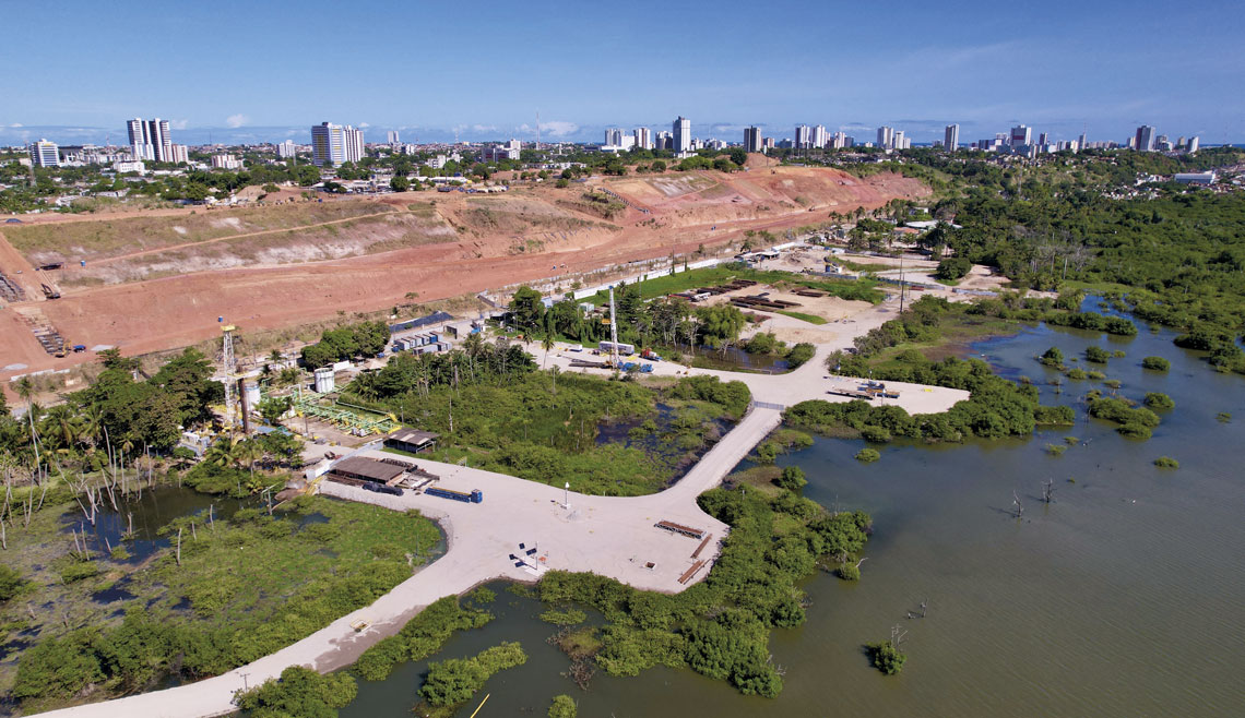
The ground above subterranean rock salt mines can begin sinking silently and gently—by just a few millimeters per year—as has been reported in Maceió, the state capital of Alagoas, since November. In a study published in the journal Scientific Reports in April 2021, researchers from the German Research Center for Geosciences (GFZ) and the University of Hannover, Germany, claimed that areas of three neighborhoods near Mundaú Lagoon—Pinheiro, Mutange, and Bebedouro—have been subsiding since 2004, without drawing much attention. Satellite image analysis indicated that the ground in the mining region sank by around 2 meters (m) between 2004 and 2020.
Marcos Hartwig, a geologist from the Federal University of Espírito Santo (UFES), reached a similar conclusion to the Germans. In an article published in the journal Acta Geotechnica in April 2023, he and colleagues from the Brazilian National Institute for Space Research (INPE) and the University of São Paulo (USP) revealed that the ground in some parts of the region sank by one meter between 2016 and 2020. “The subsidence is greater in areas nearer the mines, suggesting a causal relationship,” he states.
As a result of earthquakes and cracks appearing in houses and roads, the public authorities have been forced to relocate around 60,000 people. The first residents of the five neighborhoods considered most at risk began to leave in 2019. In December 2023, Maceió’s local government stated that an area of 3 km2, almost 3% of the city’s urban area, was at risk of sinking.
The problem worsened that month when the ground above one of the 35 mines, known as mine 18 and covered by the water of the Mundaú Lagoon, sank by around 2 m in just 10 days and then collapsed.
There have been at least 50 reports of subsidence in urban areas due to salt mining in the USA, Canada, Europe, and Asia. One of the most significant occurred in Tuzla, Bosnia and Herzegovina, where the ground above a mine sank 12 meters, destroying houses, buildings, sewage networks, and electrical lines. The mine was filled with water and closed in 2006, but as recently as 2021, the ground was still sinking by 1–4 centimeters (cm) per year.
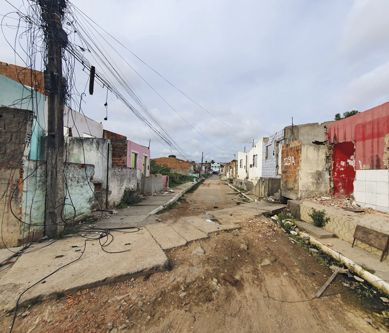
Deriky Pereira / UFAL
Area of Maceió previously inhabited and now damaged by the sinking ground
Deriky Pereira / UFALIn Maceió, the subsidence became more visible in 2018. On March 3, upon returning to her apartment in the capital of Alagoas, economist Natallya Levino of the Federal University of Alagoas (UFAL) was informed by her husband that the lights in the living room had been shaking. Cracks also appeared in the streets and in other homes in the Pinheiro neighborhood.
On the same day, the Brazilian Seismographic Network, run by the Federal University of Rio Grande do Norte (UFRN), recorded a rare magnitude 2.4 earthquake in the region. Anderson Farias do Nascimento, a geophysicist from UFRN, was intrigued by the situation: “Maceió didn’t used to experience such intense seismic activity and the effects reported by residents were never so strong.”
In May 2019, the Geological Survey of Brazil (SGB), a public company linked to the Ministry of Mines and Energy, attributed the intense tremor—and the smaller ones that followed—to the collapse or merging of underground salt mines, which provide the raw material for caustic soda and plastics and were opened and operated by petrochemical company Braskem in the 1970s.
Based on analyses carried out a few months after the earthquake between June 2018 and April 2019, the SGB concluded that the mines, at depths of between 800 m and 1,200 m, caused the ground above to subside. As a result, Braskem had to stop work at the mines and fill any collapsing mines with sand or cement. But the earth continued to sink.
“What is happening in Maceió is called induced seismicity, caused by human activity such as mining,” says Nascimento, who participated in the analysis of the tremors as part of a research project carried out with the SGB team. “The signal recorded by the equipment is different from natural tremors, indicating energy released by the earth shifting and collapsing.”
Hartwig adds that the cavities cause something known as a stress imbalance, which creates deformations in the layers above them. The phenomenon can eventually reach the surface, causing cracks in streets and buildings (see infographic below). “Ground movements begin subtly and more or less linearly, then evolve into accelerated and irregular movements,” he explains.
The role of two extensive geological faults (fractures in a block of rock) that run parallel to Mundaú Lagoon is still uncertain. Technical reports issued by the SGB state that they may have been reactivated, which would contribute to ground movements, but Hartwig and his group ruled out the influence of these faults. Nascimento, however, does not rule out the possibility: “Despite being small, the faults could be providing a way for water to infiltrate the mines, causing them to expand and collapse.”
No dialogue
The scientists are helping shed light on and address these problems. “Residents from the neighborhoods around the lagoon started calling me in 2010, asking me to look at cracks in their houses,” says civil engineer Abel Galindo Marques, a retired professor at UFAL. Marques specializes in building foundations and coauthored the book Rasgando a Cortina de Silêncios: O Lado B da Exploração do Sal-Gema de Maceió (Tearing down the curtain of silence: The B side of rock salt exploration in Maceió; Instituto Alagoas, 2022).
Shortly after the 2018 earthquake, he participated in a meeting at the Alagoas Regional Council for Engineering and Agronomy (CREA). “Four people claimed the tremors and cracks had nothing to do with the mines, which I had seen as the cause since 2017.” Hartwig says that in 2022, he asked Maceió civil defense agencies for access to field data, which would allow for more consistent analyses. In return, he was offered a report and training for his team on how to interpret satellite data for ground surface movement monitoring. “I received nothing more than a generic response—the conversation didn’t go any further,” he laments.
In the book A Cidade Engolida (The swallowed city; Pedro & João Editores, 2023), Levino and Marcele Elisa Fontana, an engineer from the Federal University of Pernambuco (UFPE), reiterate: “The absence of official data capable of guiding research and discussions has limited further studies.” After the most intense tremors, Levino and colleagues from UFAL and other universities created a WhatsApp group and a website to share studies, videos, and other materials about subsidence in the area, in addition to the YouTube channel “Relatos de uma Tragédia” (Reports of a tragedy). She also feels frustrated: “I never got to interview anyone at Braskem.” When asked to comment by Pesquisa FAPESP, the SGB stated that no researchers were available to give an interview on the subject and Braskem did not reply.
The order to evacuate houses in sinking neighborhoods has affected thousands of people. Despite having received or still negotiating compensation from Braskem, some have had to move long distances away or even relocate to nearby cities in search of affordable housing. The situation also resulted in store closures, even in neighboring areas, the deactivation of 10 bus lines, and suspension of the construction of a light rail transit (LRT) line, according to an article published in the journal Logistics in September 2023 by the UFAL group in collaboration with researchers from Pernambuco (UFPE) and Brasília (UnB).
“Other tremors could occur until the area stabilizes,” says Hartwig. His prediction is based on studies from the 1940s by American geologist Ruth Doggett Terzaghi (1903–1992), who described five stages of subsidence caused by salt mines like those in Maceió.
The first two consist of slow, imperceptible movements that can last decades or centuries. The third lasts a few years and leads to the formation of surface depressions. The fourth is collapsing of the ground and subsequent formation of craters, which may be partially filled with water.
“Before November, we were in stage 3, with subtle and progressive sinking. We have now entered the fourth stage, in which the movement has accelerated greatly, resulting in holes on the surface filled with water,” explains Hartwig. The final stage is marked by mild and irregular subsoil movements.
Scientific articles
VASSILEVA, M. et al. A decade-long silent ground subsidence hazard culminating in a metropolitan disaster in Maceió, Brazil. Scientific Reports. Vol. 11, 7704. Apr. 8, 2021.
HARTWIG, M. E. et al. The significance of geological structures on the subsidence phenomenon at the Maceió salt dissolution field (Brazil). Acta Geotechnica. Vol. 18, pp. 5551–73. 2023.
FONTANA, M. E. et al. Risk analysis of transport requalification projects in the urban mobility problem caused by a mining disaster. Logistics. 2023, vol. 7, no. 3. Sept. 4, 2023.
Republish