
 Aboard the Alpha-Crucis
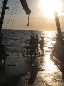
The sea is choppy and the ship rocks heavily back and forth on this morning of Monday, February 25. The waves wash onto the deck. Four men wearing white hardhats and drenched in saltwater pull the steel cable with a pyramid-shaped structure that swings back and forth before settling on the red surface of the deck. The metal pyramid has finally brought up 12 transparent cylinders holding a generous sample of mud from 121 meters down, along the island of São Sebastião on the northern coast of the state of São Paulo. In the previous attempt at a depth of 47 meters, the cylinders brought up only water and sand, without the desired mud that 19 researchers from the Oceanographic Institute of the University of São Paulo (IO-USP) have been looking for on a nine-day cruise of the oceanographic research vessel Alpha-Crucis.
Edilson de Oliveira Faria, Marcelo Rodrigues, Rodolfo Jasão Dias and Gilberto Dias take turns carrying the cylinders and depositing them into a plastic box. The mud in the cylinders is fine, sticky, dark green in color and foul-smelling. “It’s perfect!” remarks Till Hanebuth, a professor from the University of Bremen, Germany, feeling it between his fingers. “What is just mud for most people holds a lot of meaning for us,” says Michel Mahiques, director of the Institute and scientific coordinator for the first part of the expedition, February 20-24, which focused on identifying places to collect sediments at different depths over the next four days. “Muddy sediment, as we call it, is what will provide the best records of the climatic, environmental and evolutionary history of a region.” In earlier studies, sediment analyses helped in identifying climate changes over the last 10,000 years along the coast of São Paulo, as well as the levels of pollutants in Santos and Iguape over the past 100 years.
This modeling clay from the ocean floor is, by definition, a mixture of grains smaller than 62 micrometers in diameter, finer than sand. “Particles of rocks or salt, skeletal remains—any material can form mud,” says Samara Goya, a technician from the IO and university professor in Santos. “Mud works like a sponge, attracting chemical elements or organisms scattered around in the water. Sand has a fixed structure and does not attract other materials.”
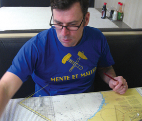
Carlos FioravantiTill checking on the courseCarlos Fioravanti
The objective of the voyage is to identify mud deposits or flows whose components should help in reconstructing the regional environment and climate, ocean currents and evolution of the southeastern Atlantic over the past 7,000 years. The cruise—a component of one of the projects supported by the Office of the Dean of Research through the Research Support Centers (NAPs) program—has brought together researchers from the IO, the Geosciences Institute and the Institute of Astronomy, Geophysics and Atmospheric Sciences at USP.
“This is our first expedition of a substantially geological nature that is going beyond the edge of the region’s continental shelf,” says Michel, who prefers to be called by his first name. Up until now, due to a lack of proper equipment, sediments could be collected at no more than 150 meters deep. “The Alpha-Crucis enables us to move farther out, deeper and more comfortably than with the Besnard,” he says, referring to the Professor Besnard, a vessel that was deactivated in 2008. On the 28th, after traversing nearly 2,000 kilometers, the Alpha-Crucis anchored in Santos alongside the old vessel with hundreds of sediment samples from up to 1,400 meters down.
“Where do the sediments found north of São Sebastião come from? We don’t know,” Michel says somewhat anxiously. The rivers flowing into that region are small and seemingly incapable of transporting so much sand and mud. To the south, the situation looks clearer. In earlier studies, Michel and other researchers from the Oceanographic Institute concluded that the nearly 2,000-kilometers-long Rio de la Plata must be the principal source of the mud that stretches to the south of the island of São Sebastião, driven by the ocean currents.
The mapping of the ocean floor during the first four days of the voyage immediately provided indications about the stability of the seabed, which is essential for extracting oil and natural gas, and about the potential for slides of sediment deposits, which can generate tsunamis. In 2002, an enormous mass of sediment slid and pushed the ocean against the coast of the island of Stromboli, Italy, causing a tsunami and aggravating the effects of a volcanic eruption. Apparently, the potential for this to happen along the coast of São Paulo is remote.
Carlos FioravantiFirst collection, February 24Carlos Fioravanti
Based on the data from the ocean floor, Michel concluded that a hypothesis about sediment movement from the coast to the ocean along this stretch of the coastline, which he introduced in 2004 based on surface samples, may actually be correct. “We are now effectively seeing sediment migration from the coast to the seabed,” he says. “We passed through a series of valleys and channels, some of them five kilometers wide and 160 meters deep, which could function as locations for receiving and distributing sediments.” The charts showing the changes in thickness and consistency of the layers of sand and mud indicated that the slope—the deeper region beyond the continental shelf—was in the shape of an amphitheater, with the stage in the deeper areas, as he had expected.
Titans on the high seas
The sediment collection points were chosen after a laborious effort that began on the afternoon of Wednesday, February 20 after the ship left the Port of Santos, and ended at dawn on Sunday the 24th. The USP team took turns day and night to track and analyze the data from the ocean floor that showed up for 83 straight hours on the monitors of the three instruments in one of the ship’s laboratories: a bathythermograph, which records changes in salinity and temperature via sensors launched into the water manually every 18 kilometers; two echo sounders, which provide information on the consistency and limits of the surface layers of sediments on the ocean floor by means of sound wave transmission and reflection; and a seismic profiler, which uses a different wave frequency to penetrate farther into the sediments because it works on a lower frequency than echo sounders. Every half-second, the profiler emitted a sound pulse that echoed throughout the ship, especially on the lower deck, which housed the cabins of the crew and some of the researchers. At a planning meeting a few days before the voyage, Michel warned that it would be “a noisy trip.”
It was lively, too. Heading against the wind, the ship rocked considerably on Thursday, February 21, the first day of the voyage. Even the more experienced of the passengers were sick with nausea and vertigo. “Compared to the Besnard, this ship is flat,” Michel says calmly at breakfast. Captain José Rezende, who is originally from Juiz de Fora in the state of Minas Gerais but now lives in the city of Niterói, agrees: “The Besnard was more bow-heavy.” He was referring to the rising and plunging of the ship’s bow, making it rock lengthwise rather than side-to-side like the Alpha-Crucis. At night the ship reached the farthest point of the cruise, 315 kilometers from the coast, which was also the deepest point, 2,000 meters. Down below, according to one of the instruments, the temperature was three degrees Celsius.

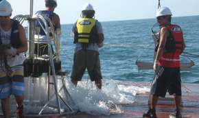
Carlos FioravantiGilberto carrying one of the multicore cylindersCarlos Fioravanti
Michel, Till, Edilson, Jasão, Marcelo and Gilberto, taking turns in front of the monitors, spent the day apprehensively, asking the captain to adjust course because they weren’t capturing anything of consequence on the ocean floor. At the end of the day, the ship calmed down and they began to make out signals from ancient valleys of rivers and lagoons, which appeared to be potential sediment collection points for the second part of the trip. “Everything we’re doing here is new to us,” remarked Till, the coordinator of the daytime team, who explored the basin of the Rio de la Plata on a similar expedition in 2009.
Even with little sleep, Michel was happy. With no Internet, phone or urgent problems to solve, he could cast aside the worries of the directorship of the Oceanographic Institute and put on his Botafogo soccer team shirt (he was born in Rio and moved with his family to São Paulo at the age of nine.) His computer endlessly played music by Titãs, Fábrica do Som, Village People, Elis Regina—as he refers to it, “good tunes and tunes I like.” The night shift looked like a group of old friends. Tall and thin, Marcelo Rodrigues, a technician who has been at the Institute since 1992, was traveling with them for the last time because he resigned to work as a geology consultant.
Edilson is a hearty fellow Rastafarian hair, speaks calmly. He studied biology, was hired as a technician at the IO in 1998, and two years later Marcelo asked him if he’d like to join in on a trip to Antarctica. He had dreamed of going there since 1982 when he served in the Brazilian Naval School in Rio and read about the plans for the first scientific expedition headed there. Shortly afterwards he saw the ship Barão de Tefé heading south. “That image has never left my mind.” He went in December 2002, stayed for a month and liked it very much. “The impression I have is that I never left.”
When he took his leave from the team on Sunday the 24th in Ubatuba, Michel handed over the scientific command to his colleague Silvia Helena de Mello e Souza, who came on board with her group early that afternoon. Michel handed her a map showing the 10 sediment collection points that he and Till had drawn up that morning, based on the previous days’ mapping. On that same day they launched the instruments, which found only sand on the seabed, and at night they again switched on the instruments that map the layers of sediment on the ocean floor.
The dirty side of science
The mud that the men on deck bring up in the cylinders acquires owners and identities as it goes to the researchers, who are organized into a production line, each with a specific task to do. “The samples from this cruise will be the ones I’ll use in my doctoral research,” says oceanographer Amanda Spera, who cuts the blocks of mud into one-centimeter-thick slices that her colleagues put on metal dishes. Amanda plans to analyze organic compounds synthesized by marine microalgae and terrestrial plants to find patterns of temperature and climate changes in the region thousands of years back. The higher the temperature, the fewer the double bonds in the carbon chain of alkenones, one of the groups of compounds to be analyzed. Thus, she says, “if algae live in a warmer environment, the number of double bonds in the alkenones is lower.”
Carlos FioravantiThe multicore and men working on deck to bring up a little of the ocean floorCarlos Fioravanti
At lunch the next day, Jasão, an oceanographer and scientific diving specialist, announced the depth of one of the morning’s collections: 841 meters. “We now have an Oceanographic Institute record.” Using one of the instruments—a four-meter-long metal cylinder weighing 450 kilos called a piston core—they collected three samples of 4.1 meters, 1.68 meters and 2.4 meters in length, contained in a white plastic tube. In the laboratory, each column will be cut into two-centimeter slices. “I’m the one who will date the columns,” says chemist Rubens Figuera, a professor at the IO who does a quick count: each column should yield 300 to 400 slices, of which he will examine the concentration of 15 chemical elements, which means 6,000 results per column of mud.
Witnessing this activity is fascinating. You can see a little of the machinery of science at work, and the things that the papers do not mention: the laborious, repetitive work, the stress of unforeseen circumstances, nascent working hypotheses, literally the dirty work of science expressed on muddy faces. The usually hidden forces of science emerge subtly, not just by dint of good questions, institutions and money, but also through friendship, respect and camaraderie. “I’m here for whatever you need,” Edilson reminds the group on Sunday night as they plan their collections.
The following day, seeing movement on the deck, Till remarked that 40 people had been mobilized to collect sediments, including the seamen who operated the winches to guide the collection equipment, the cooks who kept up everyone’s spirits with tasty meals and the mechanics in the engine room. The scientific articles resulting from this work, however, will bear the names of only a few scientists.

Carlos FioravantiMarine organisms mixed with sediment materialCarlos Fioravanti
The reports emphasize positive results that seem to have appeared like magic, with no effort, but the weariness expressed in the hoarse voices, the silence and the dark circles under the eyes of these individuals attest otherwise. “We have to unravel the mystique of Jacques Cousteau, who showed only the things that went well,” notes Michel. “On one of the expeditions I went on, everything went wrong. It’s part of the territory. You just can’t lose your enthusiasm.”
At 13:00 on Tuesday the 26th, Rubens hastily enters the laboratory and informs Silvia and Till, “We’ve lost the piston core!” Because of either a failure in a trigger mechanism that controlled the instrument’s descent, or the force of the current, the steel cable broke and the instrument went to the bottom. Heavy silence on deck. Three hours later, Silvia Helena calls the group over and tells them that, because of the accident, they would use a different collection strategy and concentrate on an area they called the mud belt. Still silent, they do a night collection at a depth of 120 meters, but with the pyramid-shaped instrument, the multicore. Slowly but surely, their spirit comes back. One night, Till played truco, a card game, with the gang. He taught them the rules, in English, and won two hands in a row.
The next 20 years
On Wednesday the 27th they beat another record: 1,400 meters. At mid-afternoon, with the collections locked up, the multicore is tied down below deck without its cylinders. For three hours, Mônica Petti, a biologist from the IO, sieved mud looking for polychaetes, mollusks, crustaceans and other marine organisms, which will then be examined under a lab microscope. “It’s been a long time since we collected organisms at these depths,” she remarked.
“We know very little about marine biodiversity in Brazil,” says José Eduardo Marian, a biologist from USP who in 2012 described the sophisticated reproduction mechanisms in squid. The number of species in the Brazilian ocean is currently estimated at 30,000, but it could be much higher, according to the preliminary results of a national survey coordinated by Antonio Carlos Marques, also at USP. One of the goals is to double the number of records of occurrence of marine organisms catalogued in the Ocean Biogeographic Information System (OBIS), an open-access database, by adding 100,000 records by March of 2014.
Problems are also surfacing. One stubborn issue is the lack of specialists who study various marine animal groups. “We need more specialists to take account of our diversity,” Marian warns. “On this piece of the continental shelf alone we have over 20 years of work, at least,” notes Michel.
Project
Increase of the research capabilities in oceanography and related sciences in São Paulo State (10/06147-5). Coord. Michel Michaelovitch de Mahiques (IO-USP); Grant mechanism Research Program on Global Climate Change (RPGCC); Investment R$15,461,637.78 (FAPESP).