
MapBiomasAzevedo has been at the helm of MapBiomas since it was founded in 2015MapBiomas
Few Brazilians have as comprehensive a view of deforestation in the country’s biomes, especially the Amazon, as São Paulo–born Tasso Azevedo. He has a degree in forest engineering from the Luiz de Queiroz College of Agriculture at the University of São Paulo (ESALQ-USP) and is head of MapBiomas, a collaborative network of more than 70 nongovernmental organizations (NGOs), universities, and tech startups that has been producing annual data and maps on land cover and use in Brazil since 2015. The collective recently began monitoring other issues linked to climate change and the environment, such as areas affected by wildfire and monthly water surface changes in the country’s biomes, as well as expanding to other South American countries and Indonesia.
Between January and December of 2023, the area deforested in the Amazon fell by almost 50%, while in the Cerrado it increased by 43%, according to data from the Real-Time Deforestation Detection System (DETER), run by the Brazilian National Institute for Space Research (INPE). MapBiomas’s monitoring also identified the opposing trends in the two regions. “Deforestation in the Amazon is highly illegal. With the return of more stringent oversight and market restrictions on products from deforested areas, the rate is falling,” he said in an online interview with Pesquisa FAPESP. “In the Cerrado, where the area subject to deforestation is larger, there is a kind of race to clear land while it is still permitted.”
Why did deforestation fall by half in the Amazon last year but grew by almost 50% in the Cerrado?
The situation in these two biomes is different. People are aware that deforestation in the Amazon is highly illegal. Around 75% of the Amazon is public land. Deforesting public land is illegal. Private properties are legally required to preserve 80% of their land—they are only permitted to clear 20%. There is therefore clearly a lot of illegal deforestation in the Amazon, in public and protected areas. But because inspections and fines were resumed in 2023, deforestation fell sharply across the region. Even the financial system, which also uses MapBiomas data, began to block credit from applicants who illegally deforest.
And in the Cerrado?
There, the situation is different. Most of the biome is private land and it is generally possible to legally clear up to 80% of a property’s area. In the Cerrado, the legally mandated reserve area is usually 20%, although it can reach up to 35% in areas bordering the Amazon. In other words, the area that can potentially be legally deforested in the Cerrado is much larger than in the Amazon. There is another interesting recent factor influencing the matter. The definition of “forest” in the new European legislation, which will ban the import of products from deforested areas starting in December 2024, uses a concept from the FAO [US Food and Agriculture Organization] that does not include approximately 70% of the Cerrado. The definition is being modified, however, so that it will encompass the parts of the Cerrado that are currently left out. So for now, there is a kind of deforestation race in the Cerrado while it is still permitted.
The Brazilian agriculture industry says there is no need for more deforestation to increase production in the sector. But data from the last four decades show that in Brazilian biomes, areas of natural vegetation have decreased and areas of pasture and cropland have increased. How do you assess this situation?
It’s true that agricultural production can be increased without further deforestation. A lot of research has been done on that. In Brazil, livestock farming is the primary use of deforested land. More than 20% of the Brazilian territory is occupied by livestock, the average productivity of which is low. Currently there is about one animal per hectare. There are well-known techniques that can be used to raise up to three animals per hectare, with ease. We could use much less land to achieve the same output, or increase output with the same land. Then, some of the current pasture areas could be repurposed for agriculture or forest restoration.
Why doesn’t this happen?
Because the agricultural frontier is still open in Brazil. There is a race to occupy the land. Where this frontier has been restricted, such as in the Atlantic Forest in São Paulo, loss of vegetation has stopped. Now, almost all agriculture in São Paulo takes place in areas that were already deforested, not in new areas. There is also a second reason for the advancement of the agricultural frontier. Decisions are made individually for each property, based on what is best for the specific situation. This leads to the expansion of activities into areas not yet deforested, often with public funding. If Brazil does not need new deforestation, then ideally there would be no form of subsidized agriculture that promotes the deforestation of new areas. We should limit agricultural funding to areas where deforestation has already occurred and that adopt low-carbon practices.
75% of Brazilian greenhouse gas emissions come from agriculture and changes in land cover and use
What is the situation regarding land use and cover in other Brazilian biomes?
Each biome has its own characteristics. The Pantanal still has the highest proportion of native vegetation of any Brazilian biome other than the Amazon. But many of the natural plains of the Pantanal are being converted into planted pasture. This is changing the water dynamics in the region. In the last 35 years, the Pantanal, which is the largest floodplain on the planet, has lost around 60% of its permanent water coverage. The risk of fire has increased, reflected in the occurrence of major wildfires in the biome in recent years. The Caatinga is also losing vegetation cover. Land is being converted for agriculture on the border with the Cerrado. Some regions are suffering from droughts and desertification. In the Pampas, there are two main issues: the loss of native grasslands, which are being converted to agriculture, and the large-scale planting of exotic species, such as eucalyptus.
Why do changes in land use and cover in Brazil emit more greenhouse gases than the burning of fossil fuels?
It’s linked to the confluence of certain factors. Brazil is currently the world’s fifth largest emitter of greenhouse gases, after China, the USA, India, and Russia. Of the 10 biggest emitters on the planet, Brazil and Indonesia are the only countries in which the majority of emissions come from changes in land use and cover, which is primarily driven by deforestation to clear new areas for agriculture. Approximately 75% of our emissions come from these changes and agricultural activities. Brazil deforests more than any other country in the world in absolute numbers. It is also the country with the most cattle. Cattle emit a lot of methane—a greenhouse gas. That’s one side of the explanation. The other is that Brazil has a cleaner energy mix, which relies less upon the burning of fossil fuels compared to other large greenhouse-gas emitting countries. Not only is our electricity cleaner thanks to our hydroelectric plants, but we also use more biofuels, such as ethanol and biodiesel, to fuel our cars.
Is it feasible to achieve zero deforestation by 2030, as Brazil has committed to internationally?
Yes, it is possible to achieve zero or near-zero deforestation by 2030. The fact that we halved deforestation in the Amazon in 2023 shows that we know how to do it. In the Cerrado, this means creating mechanisms that financially incentivize environmental services designed to preserve the forest, eliminating subsidized funding for activities that promote deforestation, and expanding protected areas.
In 2008, you were the creator of the Amazon Fund, when you worked for Marina Silva during her first term at the Ministry of the Environment. How does the fund work?
It has two sides: one to raise funds and the other to invest them. These two sides are disconnected, which makes operations simpler and faster. The fund is results-based. Less deforestation leads to lower greenhouse gas emissions. When the deforestation rate in the Amazon is lower than the average of the previous 10 years, a highly conservative conversion factor is applied to estimate the reduction in carbon emissions. Every ton of carbon not emitted into the atmosphere due to reduced deforestation allows the fund to raise another US$5 from its donors. This is the fundraising side, which has received more than R$3 billion from countries such as Norway and Germany, and more recently from the UK and the USA.
And how is the money distributed?
The fund has a steering committee that sets the rules for how the money is allocated, which is then carried out by BNDES [the Brazilian Development Bank]. There are two project types, and they are all audited upon completion. One is induced demand, in which the BNDES issues a call for proposals designed to achieve a specific objective, as occurred with the implementation of the Rural Environmental Register [CAR]. The other is spontaneous demand, in which proposals aimed at sustainable development, forest protection, or research activities are submitted. The research projects do not need to make carbon credit calculations or demonstrate that they will reduce emissions. They simply need to show that they will contribute to maintenance of the forest. In 2023, the fund resumed normal operations.
Why was MapBiomas created in 2015?
In 2012, we started project SEEG [Greenhouse Gas Emissions and Removals Estimation System] with the aim of estimating greenhouse gas emissions in Brazil. We struggled to calculate emissions due to the lack of data on changes in land use and cover in Brazil. Since we had no systematic information, we used official data on deforestation in the Amazon, which represents much of the deforestation in the country, as a proxy [an approximate representation] for land use changes nationwide. But at that time, deforestation in the Amazon was falling. So, this proxy failed to accurately reflect the reality of the issue. We decided to generate the primary data ourselves so that we could calculate land use and occupation transition matrices and thus be better able to estimate emissions.
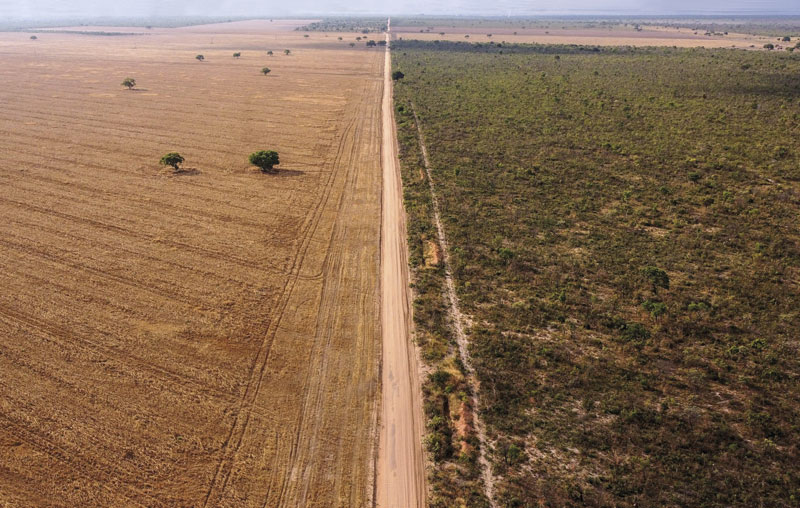
Nelson Almeida / AFP via Getty ImagesBaianópolis, on the agricultural frontier of the Bahian CerradoNelson Almeida / AFP via Getty Images
Were the official data from INPE’s PRODES and DETER systems not useful for calculating the country’s emissions?
At that time, these systems only measured annual deforestation in the Amazon, not across the entire country. They did not record the transitions in land use and cover. They did not show the fate of a deforested forest area, for example—whether it became pasture, cropland, or was abandoned. This type of data was only produced every seven years in Brazil, via the National Greenhouse Gas Emissions Inventory. There were only three maps of this type in the country back then. We set out to create maps annually and to build a historical data series that went beyond deforestation.
Weren’t there maps on land use and cover in the Amazon produced by the TerraClass system, a partnership between EMBRAPA and INPE?
The data was not annual and only covered the Amazon. TerraClass has another purpose, focusing on what happens to areas that the PRODES system identified as deforested in previous years. The methodology wasn’t what we needed for an up-to-date understanding of the transformations occurring across the country.
How did MapBiomas expand internationally?
All the data and code we use is open. They can be reproduced by any interested person or group. Today MapBiomas comprises 78 organizations in 14 countries. We are a network of 480 people who use the same methodology and approach. We started the internationalization process with an exercise involving people from South American countries that have land in the Amazon and then in the Chaco [a region that covers parts of Bolivia, Paraguay, Argentina, and Brazil]. Next, we created a MapBiomas for the Pampas, a biome that covers parts of Argentina, Uruguay, and Brazil. We now have an initiative in each of the South American countries as well as in Indonesia, home to the largest tropical forest in Asia. MapBiomas has become an international network and Brazil is part of it. This year, some African countries are expected to join.
Does MapBiomas always work with local partners?
In Brazil, we don’t make any maps that are not of our own country. What we do is empower foreign organizations to utilize data from their country. We have developed a six-step plan to make this happen, through which they put MapBiomas into operation in their country. Some tasks we do together, just for the sake of efficiency. For example, management of the data dashboard—the platform that processes and publishes all the information—is common to all. Whenever we improve the platform, the update is made available to everyone at the same time. We also use the same data-storage space on Google Earth Engine.
What is it like to be part of a network that comprises NGOs, universities, and tech companies?
It’s a joint monitoring and research network. Everyone is committed to the scientific method. Regardless of who is doing the work, we evaluate the uncertainties and subject the data to peer review. But all data is released to the public as soon as it is ready. This allows researchers to use our data in their work even before we have published our own scientific papers. Last year, 2,000 articles published in internationally indexed, peer-reviewed journals cited MapBiomas data.
How is MapBiomas funded and how much does the project cost per year?
We are mostly funded by Brazilian and international philanthropy. To date, we have had no direct donations from private companies. MapBiomas’s total budget in 2024 is expected to be around US$10 million. Brazil accounts for just under half of this amount.
How much of the funding comes from within Brazil?
It varies from year to year. Most of the money for MapBiomas’s operations in Brazil comes from other countries. I would say around 85%. We receive donations from Brazilian philanthropic organizations, but we do not receive public funds. In every country where we operate, there is a different financial arrangement.