
Lucas Cavalcante / USP
Agricultural region in the city of Bakersfield, California: cotton plantations are marked in redLucas Cavalcante / USPIn November 2013, University of Maryland scientist Matthew Hansen published the first high-resolution, digital map of the Earth’s forest cover and the transformations it has undergone between 2000 and 2012. In late 2014, researchers from the Joint Research Center of the European Union published a complete mapping of the Earth’s water supplies, produced on the basis of satellite images at a level of detail never before seen. And, beginning in 2012, the Amazon Institute of Man and the Environment (Imazon), an environmental organization with operations in northern Brazil, began to publish monthly alerts related to deforestation and degradation of the Amazon rainforest. The three initiatives use a technology platform developed by US giant Google, called Earth Engine, which was initially developed in Brazil with the decisive participation of Brazilian researchers.
“Google Earth Engine is a technological platform for analyzing environmental data on a global scale. It provides access to satellite images from the last 40 years, updated daily, and the necessary tools and massive computing power to scientists and other interested parties to allow them to detect changes and trends on the Earth’s surface, in its oceans and in its atmosphere,” explains computer scientist Rebecca Moore, Earth Engine team leader, at Google’s headquarters in Mountain View, California. “The platform is a tool that democratizes access to satellite data, turning pixels into knowledge. It is fair to say that Earth Engine was conceived in Brazil and guided by Brazilian scientists, notably the researchers Carlos Souza Júnior, from Imazon, and Gilberto Câmara, from INPE [National Institute for Space Research].”
A more sophisticated, advanced and robust version of Google Earth—the popular computer program that allows viewing of three-dimensional models of the planet—Earth Engine also allows the development of more detailed maps of the planet, aggregating satellite images, but it goes beyond this. On advantage of the platform is that it allows researchers to perform calculations and data processing in Google’s own cloud, which facilitates the extraction of information from the images. To get an idea of the power offered by this system, Hansen, of the University of Maryland, has access to 10,000 Google computers working in parallel, totaling one million hours of processing time. This computational army has analyzed 700,000 Landsat satellite images, the equivalent of 20 trillion pixels, to produce the global map of the world’s forests with a resolution of just 30 meters. “A task that would have taken over 15 years to complete on a single computer was finished in a few days using Google Earth Engine,” says Moore.

Google Engine
Temporal analysis of deforestation in the Amazon…Google EngineToday, more than 3,000 scientists and institutions around the world use the platform for their research. “With Earth Engine, we intend to tackle global challenges in areas such as food security, water availability, public health, climate change and management of scarce natural resources,” says Moore. The idea of creating a tool with this potential came about in 2008, when the Google researcher was in Brasília to launch Google Earth Outreach, a project that makes the Earth and Maps systems available to nonprofit organizations so that they can increase the visibility of their causes. “During a break in a presentation on how the Suruí indigenous tribe used Google technologies to protect their land (see box on p. 68), Carlos Souza Júnior came over and said that, although Earth and Maps were fantastic, he felt the lack of new mapping technologies that supported environmental monitoring on a large scale—a system that could map, measure and monitor deforestation in the Amazon, for example,” recalls Moore. Imazon had the scientific and technical ability to do this, but was limited by the enormous number of satellite images and computing resources required—it took weeks to run the organization’s deforestation analysis on a single computer. “That was when we realized that this was a ‘Google scale’ challenge.”
The contacts between the Brazilian researcher and his team and Google intensified from that point on, and several meetings were held in Brazil and California, where the company’s headquarters is located. In 2009, the American company and Imazon presented a prototype of the Google Earth Engine at the Climate Change Convention in Copenhagen, COP-15. The same year, researcher Gilberto Câmara, who at the time was responsible for various INPE products related to monitoring the Amazon forest, was invited to take part in developing the platform. “Câmara guided us on a series of data characteristics and configurations that Earth Engine needed to work with, such as the ability to carry out temporal analyses. And he recommended that we support researchers working on analyses of changes in surface coverage over time,” says Moore, who will be in João Pessoa, Paraíba State, in April 2015 to participate in the XVII Brazilian Symposium on Remote Sensing. She will speak on Google mapping technologies in the special session “Big Data in Earth Observation: infrastructure and spatio-temporal analyses.”
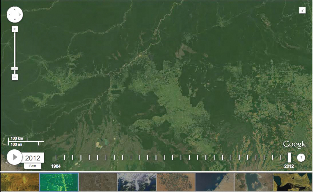
Google Engine
…human occupation in 1984 and 2012 along highway BR-364 in the state of RondôniaGoogle EngineThe first operational project to use Google Earth Engine was a forest monitoring system created by Imazon. In 2012, four years after the initial contact with Google, the organization launched its new Deforestation Alert System, powered by Earth Engine (SAD-EE), in Rio de Janeiro during the United Nations Conference on Sustainable Development, Rio+20. “Google has made things simpler. The integration of our Deforestation Alert System, launched in 2008, and Google Earth Engine dramatically reduced the time spent by our staff in managing data and satellite images. SAD-EE represented a revolution in the way we monitor our forests. With it, we produce deforestation alerts quickly, making the fight against illegal deforestation more effective,” says Souza Júnior, who is a geologist and researcher at Imazon, headquartered in Belém, Pará State.
The first major advantage offered by SAD-EE, according to the researcher, is that the tools for data and satellite image processing, editing digital maps and mapping validation are provided by Google and run on Google’s computers. Thus, the time required for pre-processing, analysis, dissemination of data and generation of alerts is reduced considerably. The second advantage is the possibility of integration with mobile communication systems, smartphones and tablets, and the Internet. “This facilitates user access to deforestation and forest degradation alerts,” says Souza Júnior. He also stresses the enormous collaborative potential of SAD-EE, as it allows anyone to provide data and information collected in the field in real time.
 Besides Imazon, at least a dozen Brazilian researchers and institutions use Earth Engine. One is the Life Center Institute (ICV), a non-governmental environmental organization based in Cuiabá, Mato Grosso State, whose focus is on projects that reconcile agriculture and forestry production with environmental conservation and restoration. “One thing that is different about these technologies is speed in access to and processing of remote sensing data,” says forest engineer Ricardo Abad, coordinator of the ICV Geotechnology Center. The institute is involved in various field activities, such as experiments in the recovery of permanent conservation areas (APPs) and springs, in addition to projects to intensify livestock raising. Data from these experiments is collected, stored and shared through tools based on Google Geo technologies.
“After collecting high-resolution images in the field—whether using balloons, kites or UAVs [unmanned aerial vehicles]—we archive them in the Maps Engine, a platform for storing and sharing geospatial data. At the same time, we use smartphones based on the Android operating system to access electronic forms for collecting information in the field using the Open Data Kit. This data, in turn, is stored in Google cloud, which allows it to be accessed from anywhere in the world where the Internet is available,” said Abad. Open Data Kit (ODK) is an application that allows collection and submission of data to an online server using Android-based mobile devices.
ICV technicians and researchers also use Google tools to verify deforestation alert images provided by Imazon and INPE. “The ease of access to very recent images allows us to quickly generate reports to support enforcement actions. We use the Google Earth Engine platform to generate multi-temporal classifications for land use and cover and thus document the advance of crops, pastures and hydroelectric plant reservoirs, among others, which end up causing deforestation,” said Abad. “We recently used these images to monitor the filling of the reservoir of a newly built dam on the Teles Pires River, which serves as the border between the states of Pará and Mato Grosso, and noted the flooding of large areas of forest.”

Google Engine
First digital map of the Earth’s forests based on satellite imagesGoogle EngineEarth Engine is also being used by researcher Lucas Schmidt Cavalcante, of the University of São Paulo Institute of Mathematics and Computer Science (ICMC-USP), to identify and monitor crops through satellite images. The ultimate goal of this monitoring is to improve production estimates. “My background is not in remote sensing and my contact with this field began last year during a four-month internship at Google in California,” explains Cavalcante, who has a degree in Computer Science. “That was when I realized that Earth Engine could be used in an interesting way for the classification methods I was developing for my master’s project, with funding from FAPESP. The objective is to study technologies capable of detecting different agricultural crops. I also plan to assess the regions in São Paulo in which sugarcane is planted.”
During the period in which he interned at Google, from May to August 2014, Cavalcante worked with the team developing Earth Engine. “My goal was to expand the Earth Engine API in order to enable time-series analysis of satellite data. I was responsible for implementing an algorithm that detects changes and identifies trends in regions with vegetation. For example, it can detect deforested regions and determine how long the process took.” An API (Application Programming Interface) is a set of routines and programming standards for accessing a software application or web-based platform.
“Sugarcane farming is of great importance to Brazil, and the state of São Paulo accounts for 60% of domestic production. Thus, being able to estimate and monitor sugarcane production is fundamentally important,” he says, stressing that the initiative to develop remote sensing tools to improve monitoring of agricultural production worldwide was one of the actions proposed during the meeting of Agriculture Ministers of the G20 countries—the group of the world’s most developed nations—held in Paris in June 2011.
At São Paulo State University (Unesp) in Presidente Prudente, the cartography engineer Arlete Meneguette, a professor in the Cartography Department, has extensive knowledge of Google Geo solutions. In addition to teaching her students how to use these tools, she trains cartographers, educators and other professionals who use these systems. With a PhD in photogrammetry from the University of London, Meneguette is a volunteer with Google Maps, leader of the Google Educators Group in Presidente Prudente and regional editor for Google Map Maker, which allows Internet users to add new elements to Google Maps and Google Earth.
“There is democratization of access because users become producers and consumers of georeferenced information,” said Meneguette. “When contextualized and meaningful, geoinformation can be transformed into spatial knowledge. This is where Google stands out, because it organizes the world’s information and makes it globally accessible and useful.”

GoogleChief Almir Suruí used Google Earth…Google
In her research on geocollaboration—a strategy that allows professionals in the field and volunteers to generate georeferenced data using cognitive maps, GPS navigators, mobile sensors and web mapping tools—the Unesp professor has validated Google collaborative and participative mapping platforms. “I chose them deliberately, because they are the most widespread and used, and I realized that their users needed theoretical and methodological knowledge,” she says. “Collaborative cartography is becoming increasingly important because it allows users to contribute their local knowledge in order to improve the maps used by millions of people.”
Suruí tribe monitors its own territory
In addition to being relevant to scientists at universities and research institutions in Brazil, Google Geo technologies are also a vital tool for the Suruí, an indigenous group living in the states of Rondônia and Mato Grosso. The relationship between the Brazilian indigenous tribe and the computer giant began in 2007 when chief Almir Suruí visited an Internet café, used Google Earth and saw its potential for preserving the heritage and traditions of his tribe.

Google… and saw its potential for preserving the heritage and traditions of his tribeGoogle
Then Almir Suruí, hailed as a “Forest Hero” by the United Nations in 2013, invited the Google Earth Outreach team, led by Rebecca Moore, to visit his tribe and teach them how to use Google mapping tools to protect the forest and the culture of his people. Tribe members learned to create and post videos on YouTube, mark the location of content and insert it into Google Earth, sharing their history and way of life. In 2012, with support from Google, the tribe launched the Suruí Cultural Map during the Rio+20 Corporate Sustainability Forum, part of the UN Conference on Sustainable Development held in Rio de Janeiro.
The Suruí, who had their first contact with white men only in 1969, also learned to use smartphones to watch over their territory and record cases of illegal logging. They thus actively protect the forest reserve where they live. They take photos and videos with GPS location data using mobile phones, upload them to Google Earth immediately and alert the authorities to logging activities. They also use Open Data Kit to monitor the carbon stock in their forest and trade on the carbon credit market. “The Suruí were the first indigenous people in the world to sell carbon credits with international certification,” says Moore.
In January 2015, the Google Earth Outreach team attended a meeting with more than a dozen indigenous leaders in Cacoal (Rondônia State) interested in replicating the Suruí’s successful experience in their territories using Google mapping technologies.
Training of the indigenous tribes in the states of Rondônia, Pará and Amazonas should take place in 2015, according to Google.
Republish