
Gabriela Biló/Content Estadão newspaper Pollution in sight: residues that leaked from the reservoir in Mariana form a brownish patch at the mouth of the Doce RiverGabriela Biló/Content Estadão newspaper
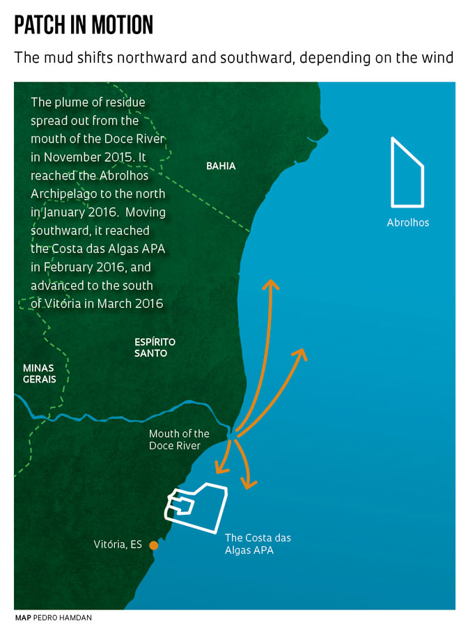
In January 2016, as they flew over the coasts of the state of Espírito Santo and southern Bahia State, biologists, oceanographers, and technical personnel from federal environment agencies recognized dark smudges on the surface of the sea formed by the accumulation of metallic residues that had leaked from the reservoir owned by mining company Samarco in Mariana, Minas Gerais State in November 2015. The slick, also called a plume, was approaching the Abrolhos Archipelago, one of the principal marine life preserves on the Brazilian coastline.
As determined shortly after the accident, the smudges represented not only the undesirable traces of the extraction of iron ore in Minas Gerais but also one of its consequences. In the midst of the dark green patches were colonies of algae and other microscopic marine organisms—phytoplankton—areas that extend for tens of km, much larger than observed in previous years, according to analyses by researchers from the Federal University of Espírito Santo (UFES).
Another peculiarity was that the organisms were rapidly growing and multiplying as a result of the excess iron in the tailings from the Mariana mining company that had spread into the sea from the mouth of the Doce River, which they reached at the end of November 2015. Since then, having been continuously carried into the ocean by the river, the waste has formed a moving slick that shifts up and down along 200 km of coastline to the north and south of the Doce River. It has upset the marine balance, as indicated by the mass of phytoplankton, and reached at least two marine life preservation facilities.
“Patches of phytoplankton are common in summer, but not this kind,” explains Alex Bastos, a professor of oceanography at UFES, speaking in late February 2016. Preliminary analyses indicate that the algae colonies are composed of organisms that form and die off within only a few days, more quickly than usual. This accelerated decomposition of organisms removes oxygen from the seawater, a situation that has unpredictable consequences for communities of marine organisms.
Furthermore, the diversity of species in the ocean had declined by almost half. Working with his UFES oceanography team, Camilo Dias Júnior found at most 40 species of phytoplankton per sample analyzed; prior to arrival of the mine tailings, researchers could identify 50 to 70 different species. Researchers and technical personnel suggest that nature may have selected for survival those varieties best adapted to the excess iron introduced by the discharge of residues into the sea.
In his flights over the coasts of Espírito Santo and Bahia, Claudio Dupas, coordinator of the Environmental Geoprocessing and Monitoring Center at the Brazilian Institute of the Environment and Renewable Natural Resources (IBAMA) office in São Paulo, observed a large number of fishing boats near the phytoplankton slicks at the mouth of the Doce River. Fishermen had discovered that large schools of fish had been attracted by the abundance of food.

Gabriela Biló/Content Estadão newspaper In Governador Valadares, MG: the mud took over the Doce River in November, 2015 degrading the water supply for city residentsGabriela Biló/Content Estadão newspaper
Based on preliminary water quality analyses and observation of the overall scenario, the IBAMA team produced a technical report warning about changes in water quality, adversely affected by the discharge of wastes into the sea. Based on that report—and as a precaution to prevent the public from being harmed by eating contaminated fish—a federal judge in Vitória acted on February 22, 2016 to order an indefinite ban on fishing in the vicinity of the mouth of the Doce River. “As soon as the court decision was issued, Guanadir Gonçalves, superintendent of IBAMA in Vitória, asked me to draw the boundaries of the prohibited zone. The map was posted on the Internet and transmitted to the cell phones of inspectors in the field that same day,” says Dupas.
Since January 2016 it has been possible to track the movements of the patch of residues using maps generated by IBAMA from satellite images. They are available at www.governancapelodoce.com.br (use the tab for tracking the plume in the sea). The site is maintained by Samarco. Meanwhile, the site www.siscom.ibama.gov.br/mariana features high-resolution satellite images from both before and after the accident, depicting the area from the dam out to the river mouth. Maps indicate that wastes have now traveled to a point 50 km south of Vitória, capital of the state of Espírito Santo, and affected three marine environment preserves, the Santa Cruz Wildlife Refuge, the Costa das Algas Environmental Protection Area (APA), and one of the principal areas where loggerhead sea turtles (Caretta caretta) lay their eggs, a 37 km strip of beach known as the Comboios Biological Reserve. “We cannot yet evaluate the impact on the environment, marine life, or the lives of the residents in the region,” says Dupas.
Since November 5, 2015, when the Fundão dam collapsed and leaked, until the enormous mass of tailings from the extraction of iron ore eventually reached the ocean, the region has undergone a profound transformation. The debris destroyed houses and forests along the banks of the Doce River, causing the death of 18 people as well as the demise of tons of fish and aquatic organisms. Biologist Flávia Bottino participated in the expeditions conducted by the Independent Group for Environmental Impact Analysis (Giaia) along the Doce River in November 2015 and observed that the water was extremely turbid, which restricted the penetration of light and impaired the survival of organisms. Biologists found fresh water shrimp that had survived the disaster, but benthic organisms that live on the river bed had been buried.
Uncertain limits
The high concentration of heat-absorbing solid particles may have caused water temperature to increase to about 30oC. “The river water was hot,” Bottino noted. Analyses of water samples collected in December 2015 along a stretch of about 800 km of the river by the University of São Paulo (USP) in Ribeirão Preto, Federal University of São Carlos (UFSCar) in Saõ Carlos and Sorocaba, Paulista State University (Unesp) in São Vicente, and the University of Brasília (UnB) showed elevated concentrations of manganese, iron, arsenic, and lead. Rain may exacerbate the situation by washing the banks of rivers that are covered with wastes and carrying the material into the sea.
From collections made aboard the Brazilian Navy ship Vital de Oliveira Moura, the UFES team found that 25 km east of the mouth of the Doce River, the residues form a layer 1 to 2 cm thick on the mud at the bottom of the sea, which is 25 meters (m) deep at that point. “We are seeing a rapid accumulation of tailings on the ocean floor,” says Bastos, from UFES, based on collections made since November, 2015 shortly after the dam collapsed (see Pesquisa FAPESP Issue nº 239). “Not even during the worst floods has there been such a heavy accumulation of river sediments on the sea floor.”
 Early in February 2016, when UFES researchers met with representatives of IBAMA, the State Institute for the Environment and Water Resources (IEMA), and the Chico Mendes Institute for Biodiversity Conservation (ICMBio), Bastos commented that the concentration of iron on the ocean floor had increased twenty-fold compared with levels prior to the accident. Aluminum content has grown to 10 times its former level and chrome and manganese have quintupled. Renato Rodrigues Neto, another UFES professor, observed that the flow rate of the river had surged from 300 cubic meters per second (m3/s) prior to the dam breach to about 4,000 (m3/s) thereafter. This increases the volume of metallic waste-laden mud being discharged into the sea.
Satellite images indicate that metallic residues may have reached the Abrolhos Archipelago early in January 2016, although as Dupas points out, it is still not possible to differentiate the sediments from the Doce River, situated about 200 km from those islands, from those of the Caravelas River, which drains into the region. According to Dupas, the results of the analyses now being done will probably be announced in April 2016.
Studies of other marine areas have indicated that industrial waste can travel far beyond the sites where originally produced, blend with seabed sediments and potentially reactivate when disturbed by fishing nets, or become absorbed by marine organisms. A team from the USP Oceanographic Institute (IO) identified heavy metals (lead, copper, and zinc) and organic petroleum derivatives produced in the São Paulo industrial zones of Santos and Cubatão, located 15 km inland from the sea, that had mixed with the mud from the seabed at a depth of 100 m and a distance of 200 km from the coast. Scientists had not previously thought that pollution generated on land could travel so far.
Environmental conditions
These conclusions are helping scientists think about what could happen on the coasts of Espírito Santo and neighboring states as the mud from the mining company disperses. “Strictly speaking, it seems at first glance that the events are not connected,” says Michel Mahiques, a professor of oceanography at the IO-USP who coordinated the studies in Santos. The leak from the Samarco facility in Mariana was an acute event, involving an intense discharge of wastes while Santos and others, like Guanabara Bay in the state of Rio de Janeiro, are chronic cases involving decades of continuous release of pollutants. “What they have in common” he says, “is that there are portions of the seabed where environmental conditions allow for the deposit of materials generated by human activity, even at great distances from their source.”
In an earlier study of the coast of Santos, Mahiques’s group identified Cesium-137 isotopes from atomic explosions or nuclear power plants that generate that type of material. “Cesium transported by the atmosphere has adhered to tiny particles on the sea floor,” he says. “We can call those cases ‘teleconnections’ in which one event at a given point on the planet can affect regions that are very far away.” Mahiques notes that classic cases are the nuclear power plant accidents at Chernobyl in 1986 and at Fukushima in 2011.

Daniel Marenco/O Globo News AgencyVila de Mariana, devastated by the mud from the Fundão dam: the effect extends more than 800 km over land, river, and seaDaniel Marenco/O Globo News Agency
“We need to take another look at the potential for accumulation of the material in the marine environment,” Mahiques declares. His studies indicate that pollutants accumulate primarily in belts of mud that usually measure 3 to 4 km wide and tens of kilometers long, found on the so-called continental shelf, on an ancient undersea landmass. “There is a long-distance effect. Sediments linger at points far from their sources. Two hundred km is the limit we have reached, but we don’t yet know whether the residues can spread further.” Mahiques argues that two basic concepts about the way the continental shelf functions need to be revised. The first is that only a small volume of materials from the continent will reach the sea. The second is that coastal environments hold back the dirt. “The volume is not small, nor are estuaries a perfect filter of residues that were generated on the continent.”
The researchers analyzed 21 samples of sediments collected in 2005 along with more recent specimens gathered by the oceanographic vessel Alpha Crucis. Their findings indicated that the levels of lead, zinc, and copper at 100 m depth, more than 100 km from the coastline, resembled those found in Santos Bay, although lower than the highest levels observed in the Santos Estuary, an are near land where river and sea waters mix. The concentration of lead in marine sediments in the estuary varied from 9 milligrams per kilogram (mg/kg) in uncontaminated areas to 59 mg/kg in samples taken from the bottom in port. This figure represents a five-to tenfold increase compared with pre-industrial levels. The study authors state that industrial pollutants mixed with the mud at the bottom of the sea could easily get back into circulation as a result of intense movements of water, human activities such as dredging carried out to expand the ports or fishing with heavy nets that disturb the sea floor.
Previous studies by researchers from the IO-USP had shown that the continuous discharge of residential wastes and industrial pollutants into Santos Bay was probably one cause of the reduced diversity among marine organisms in the region compared with the situation in less polluted areas.
At about the same time, a team from Unesp in São Vicente had found levels of four heavy metals—cadmium, copper, lead, and mercury—higher than legal limits in samples of water, sediments, and in the bodies of crabs in the mangroves of the municipalities of Cubatão, Bertioga, Iguape, São Vicente, and Cananeia. In regions where those metals are most concentrated, crabs exhibited a higher proportion of cells bearing the genetic alterations associated with the occurrence of deformities (see Pesquisa FAPESP Issue nº 225). A study by a team from the Federal University of Rio Grande published in November 2015 associated metal contamination with fibropapillomatosis, a disease that attacks sea turtles specifically, characterized by the formation of benign tumors on the skin of green sea turtles (Chelonia mydas) in Ubatuba, São Paulo State, since the animals examined presented higher than normal levels of copper, iron, and lead, when compared with healthy specimens.
“When we think about law and public policy, if we want to draft legislation that will impact future environmental accidents, we have to look further ahead and review the definition of the area of influence, since the effect can be much more extensive than imagined,” Mahiques says. Bastos, from UFES, observed that intense environmental damage can result from minor changes in the concentration of metals in sea water, even when the limits are below the maximums established by environmental laws.
Scientific articles
FIGUEIRA, R.C.L. et al. Distribution of 137Cs, 238Pu and 239 + 240Pu in sediments of the southeastern Brazilian shelf – SW Atlantic margin. Science of the Total Environment. V. 357, p. 146-59. 2006.
MAHIQUES, M.M. et al. Mud depocentres on the continental shelf: a neglected sink for anthropogenic contaminants from the coastal zone. Environmental Earth Sciences. V. 75, No. 1, p. 44-55. 2016.
SILVA, C.C. da et al. Metal contamination as a possible etiology of fibropapillomatosis in juvenile female green sea turtles Chelonia mydas from the southern Atlantic Ocean. Aquatic Toxicology. V. 170, p. 42-51. 2016.