
ICM-BIOSurrounded by forest the cerrado area is growing over the former riverbed in RoraimaICM-BIO
Seen from afar the Amazon is almost always the same; a sea of green, of forest. Deforestation is (still) concentrated on the edges, in areas on the agricultural boundary, like the north of Mato Grosso and Rondônia and in south central Pará. In these places, in which there used to be dense, thick vegetation, there are now pastures, plantations, towns or simply devastated regions. It is reasonable to suppose that zones that were cleared of forest by man a few decades ago and then abandoned may initially give rise to a more open green formation, in the style of fields and cerrados. But what might explain the occurrence of great “blotches” of savannah – vegetation of a very much drier climate than that in the north of Brazil – right alongside forests, in places in the Amazon where there has been almost no recent deforestation, such as in the east of the island of Marajó and on stretches of the banks of the Madeira River and the Branco River in Roraima?
For geologist Dilce Rossetti, from the National Space Research Institute (Inpe), in São José dos Campos (SP), the answer is closely linked to the natural history that molded the characteristics of the drainage basins and the relief of the Amazon. Ancient river beds, along which water has not flowed for thousands of years, suffered from a process of sedimentation, became paleochannels and paleorivers – and it was precisely over these buried segments of rivers from the past that a more sparse vegetation, in which grasses and few trees predominate, flourished naturally. And this was not the only thing. According to the scene proposed by the researcher, who is a specialist in the reconstitution of landscapes from the past with the help of remote sensing data, climate change may not have been the only factor that altered the course of the former rivers. “Reactivation of the tectonic faults is probably responsible for this phenomenon”, states Dilce. “People think that the Amazon is extremely stable, but it has eight regions where earthquakes occur”. Although they do not usually hit the headlines because their epicenter is generally in uninhabited zones and the forest, some earthquakes in the region may be large and reach 6 or 7 on the Richter scale.
This theory gained acceptance after Dilce, between 2005 and 2008, coordinated an extensive multidisciplinary study in a pilot area in the Amazon, the lower Tocantins and Marajó Island region in the northeast of Pará. The Marajó project, as researchers call the initiative that received funding from FAPESP, have reconstituted the geological history of the area from the Neogene period, 23 million years ago, until the present day. Several aspects of the region were studied; variations in vegetation patterns in geological time, the occurrence of earth displacements caused by movement along tectonic faults, the sediment deposited in former environments, like rivers, lakes and flood plains, variations in sea level, and climate changes. Various analysis tools were used in the studies. Satellite and radar images were used to characterize the area spatially and sediment samples were collected at depths of up to 120 meters. Dating and chemical analysis techniques of the organic material preserved in the sediment were also used to better reconstitute the succession of landscapes over time.
 Located at the mouth of the Amazon River, some kilometers from the mainland, the island of Marajó covers almost 50,000 km² – 33 times bigger than the area of the city of São Paulo – and has a pattern of vegetation cover that is uniquely distributed: almost two thirds of the area, especially the midwest, is covered by typical equatorial forest; the other third, to the east, is a mosaic of more open forest, crisscrossed by flooded fields and savannah-style formations. According to the researcher from Inpe, this division of the island into two different vegetation profiles has its origin in its geological history.
Separation of the continent
Up until around 10,000 years ago there were practically only dense forests on Marajó, with the exception of the areas intersected by its ancient drainage basin. The island was also part of the continent and its current northern part was under the sea. Tributaries of the Tocantins River snaked across its territory. Then its separation process from the mainland began. The resettling of a tectonic fault changed the course of the Tocantins, whose waters changed from flowing in a northwesterly direction to a northeasterly, which opened the way to severing the physical link of Marajó, today considered to be the world’s largest freshwater island, with the rest of Pará. A fault that roughly divides the island in half also moved. “This meant that the east of the island sank slightly and became more subject to flooding, initially being invaded by seawater, and after this subsided, by flooding during the rainy season”, says Dilce. Natural conditions had been created for the island to have two different types of vegetation. As the Atlantic ocean receded, sand and mud filled the bed of ancient estuaries and rivers. Periodic flooding in this sector made it impossible for dense forests to survive in this area and created the environmental conditions 6,700 years ago for an open field vegetation to develop at certain periods of the year. At the same time, in the western, more stable part of Marajó, the forest remained intact. Disconnected from the Tocantins Rivers from the start of the separation process of the island from the continent, a large number of the water courses of this zone dried out and over time became locations where the vegetation started growing, initially with grasses and bushes, and after with forest species.
With satellite images, and particularly with radar images that scan the characteristics of the terrain even on cloudy days, the skeleton of the network of paleorivers and paleochannels can be seen by the trained eyes of the scientists. Features come to light that are today covered by soil and vegetation. Sometimes the ancient abandoned bed, today covered by forest or savannah, is found in an area in which there are no more remaining water courses in the surrounding area. Everything was buried. In other locations, it is close to what remained of the old river, which due to tectonism had to change the course by which its waters cut through the relief. Located in the area dominated by savannah on Marajó, the largest lake on the island now, Arari, is enclosed in the paleoestuary that was fed by a river that has today disappeared and originated on the continent.
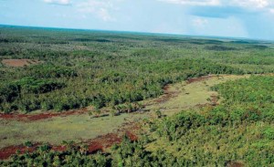
 In other parts of the Amazon the movement of the tectonic faults also altered the course of important rivers and left a series of paleochannels interconnected with traces of this shake-up in the topography. In the center-south of Roraima, in a region within the National Park of Viruá, around 190 km from the state capital, Boa Vista, a network of paleorivers was found close to the left bank of the present day Branco River. In this same zone there is an extensive area of savannah in the middle of the forest. “Some of these paleochannels are still active and may become filled with water at times of flooding”, says geographer, Hiran Zani, who is studying the area in his Ph.D. work on remote sensing at Inpe. “Preliminary dating of the organic material preserved in sediment samples indicates that there has been a change in the landscape over the last 20,000 years.”
Old and new Madeira
A similar case is that of the Madeira River in the southernmost part of the State of Amazonas. In this area a 200 kilometer-long segment of the river moved to the east because of a rearrangement of the tectonic faults that occurred some thousands of years ago. Several of the tributaries on the right bank of the Madeira also changed place. Over the former beds of these rivers, which became clogged with sandy sediment, grew a field or cerrado-type vegetation. In remote sensing images and aerial photos this type of more open vegetation contrasts strongly with the forest that surrounds it. “As on the island of Marajó, the ‘blotches’ of savannah in this region coincide precisely with course of ancient rivers that are today abandoned in the landscape”, states Dilce. “Climate change alone in the past would have been incapable of producing strips of savannah that snake around within the forest and mimic rivers.”
Attributing in good measure the origin of these isolated points of savannah in the Amazon to the occurrence of paleochannels of a tectonic origin is a new idea and still not agreed upon by everyone. Physicist Luiz Carlos Pessenda, from the Center of Nuclear Energy in Agriculture (Cena) of the University of São Paulo (USP), who is involved with some of the studies with Dilce on the island of Marajó and at other points in the north of Brazil, only partly agrees with the thesis of the researcher from Inpe. “Geological data are important but complementary”, Pessenda states. “The climate question is always relevant, regardless of the data about tectonism”. According to the physicist, the “blotches” of fields and cerrado emerged because the region’s climate was much drier between 3000 and 9000 years ago. Isotopic and geochemical studies of soils and lake sediment indicate that it may have rained a lot less in the Amazon and the northeast of Brazil during this period, making it unfeasible for a tropical forest to persist in certain zones and opening up the way for the establishment of fields and cerrado.
On one issue Pessenda and Dilce totally agree: the areas of natural savannah appear to have been losing space over the last few years and the dense and impenetrable forests are encroaching on their territory This is likely to occur, unless there are further major changes in the landscape or climate in the Amazon.
The project
Integration of biological and geological data in the lower Tocantins-Island of Marajó region: key to the analysis of the biodiversity (nº 2004/15518-6); Type Regular Research Awards; Coordinator Dilce Rossetti – Inpe; Investment R$ 423,269.10 (FAPESP)