In June this year, amidst the biggest climate and socioenvironmental catastrophe in the southern Brazilian state of Rio Grande do Sul (RS), civil engineer Luciana Paulo Gomes was categorical. “This will definitely happen again, and we need to be ready,” warned the civil engineering postgraduate researcher at Vale do Rio dos Sinos University (UNISINOS) in São Leopoldo, part of state capital Porto Alegre’s Metropolitan Region.
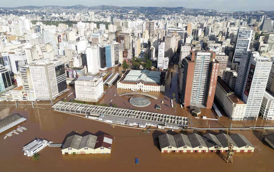
She was referring to the relentless heavy rainfall that struck 478 of the 497 RS municipalities in the two previous months, and left part of the state capital submersed (see Pesquisa FAPESP issue nº 340). In May alone, Porto Alegre recorded 513.6 millimeters of precipitation, almost five times the average for that month. All this excess water, coupled with overflow of the rivers feeding Guaíba Lake, caused the city to flood. Images of Porto Alegre under water went viral globally, and the Salgado Filho airport, one of Brazil’s most important hubs, was rendered inoperative for an indeterminate period. Of the city’s 81 neighborhoods, 46 were affected. Five people died and 13,000 were left homeless.
Specialists consulted by Pesquisa FAPESP had no doubt that the damage caused by this year’s floods could have been significantly reduced had the overflow protection system, installed 54 years ago in the north and central regions of the city, functioned correctly.
“We wouldn’t have 10% of the flooding we saw in Porto Alegre if this system, which is sound and efficient up to a level of 6 meters [m], had received a minimum of routine maintenance,” states electrical engineer Vicente Rauber. A specialist in energy and environmental planning, Rauber directed the city’s Rainwater Management Department (DEP) from 1990 to 1992, merged in 2017 into the Municipal Water & Wastewater Department (DMAE). He recalls that in 2014 there was a plan to modernize the state capital’s antiflood system. “At the time, the federal government had earmarked R$124 million for works, but without the studies required for the continuity project, the funding returned to the federal government in 2019,” he says.
Environmental engineer Fernando Fan, of the Institute for Hydraulic Research at the Federal University of Rio Grande do Sul (IPH-UFRGS), has a similar opinion. “The protection system was well conceived, and the downtown area of Porto Alegre should have been protected, even with Lake Guaíba at 6 m above its normal level,” he explains. “However, when the water level reached 4.5 m, we saw failures occurring. This would possibly have been avoided without the background negligence in the maintenance of the system, and if occasional refinements had been effected.”
Flooding has been a constant concern for the population of Porto Alegre, a city bordered to the north by the Gravataí River, and to the west by Lake Guaíba. With a good part of its area on the flat, the RS state capital is some 10 m above sea level, but only 3 m higher than the Guaíba. In the last 100 years, historical flooding has been part of life for residents. The biggest and best-known flood event occurred in 1941, when Guaíba Lake rose by 4.75 m in 10 days and encroached upon the downtown area; this had been the lake’s highest level before the occurrences of 2024. Two other significant events, in 1965 and 1967, moved the city to plan a flood protection system.
The system
Installed in the early 1970s by the then Brazilian Works & Sanitation Department (DNOS), the protection system comprises 68 kilometers (km) of dikes and barriers erected on the banks of the Gravataí and Guaíba, which surround the city (see map above). Made from earth, these dikes are reinforced structures 3 m above ground level, and 6 m above the average level of Lake Guaíba. Important highways pass over these waterways, such as the BR-290 National Highway — known as the Freeway — to the north, and Avenidas Castelo Branco (Navegantes neighborhood), Edvaldo Pereira Paiva (Praia das Belas) and Diário de Notícias (Cristal). Close to the historic center, between the coach terminal and Praia das Belas neighborhood, the earthen dike becomes a 3-meter-high concrete retaining wall with 2.6 km of extension, known as Muro da Mauá (Mauá Wall), separating the avenue of the same name from the port docks. The protection system has at least five earth dikes (some incomplete), known as internals, installed in neighborhoods that border creeks to prevent them from overflowing.
Along the external dikes, over which avenues, highways, and Muro da Mauá pass, there are 14 iron floodgates. “If the level of the lake starts to rise significantly, these gates are closed to prevent flooding in the urban area,” explains civil engineer Carlos Tucci, a retired professor at IPH.
Pumping stations are installed at 23 points of the containment system. Known as pumphouses, these are designed to drain excess rainwater and, by way of underground pipes, discharge it into the Guaíba and nearby creeks. According to Fan, this pumping system has sufficient head (pressure) that when all is functioning well, surface water in the city is directed to the lake and streams, with no way of returning, even after they overflow.
The system was planned to protect the city from a flood such as the 1941 event, and has a safety margin of 1.25 m in relation to the highest level recorded that year — 4.75 m. Before the system was ready for operation, a 3-meter rise in the level of the Guaíba would flood the docks and downtown Porto Alegre. If this structure had been operating as expected, in principle it would have been sufficient to contain this year’s flooding, because on May 5, at the height of the crisis, the Guaíba reached 5.33 m. However, a series of failures prevented the system from functioning properly.
At the beginning of May, 19 of the 23 pumphouses were flooded by the rainwater and had to be disconnected from the electrical grid due to the risk of electrifying the water and causing accidents. Thus, instead of directing water away from the city, the pipes at these stations served as an entry channel for waters from the Guaíba.
This was exemplified by what happened in the Menino Deus neighborhood, in the southcentral area of the RS capital. During the first flood peak on May 5, the pumphouse there stopped working due to a lack of generators, and the neighborhood was inundated. “In the second peak on May 14, almost as sizeable as the first, there were generators in place, and the neighborhood stayed dry,” says environmental engineer Iporã Possantti, a doctoral student at IPH and creator of an interactive map of flood potential in areas of Porto Alegre.
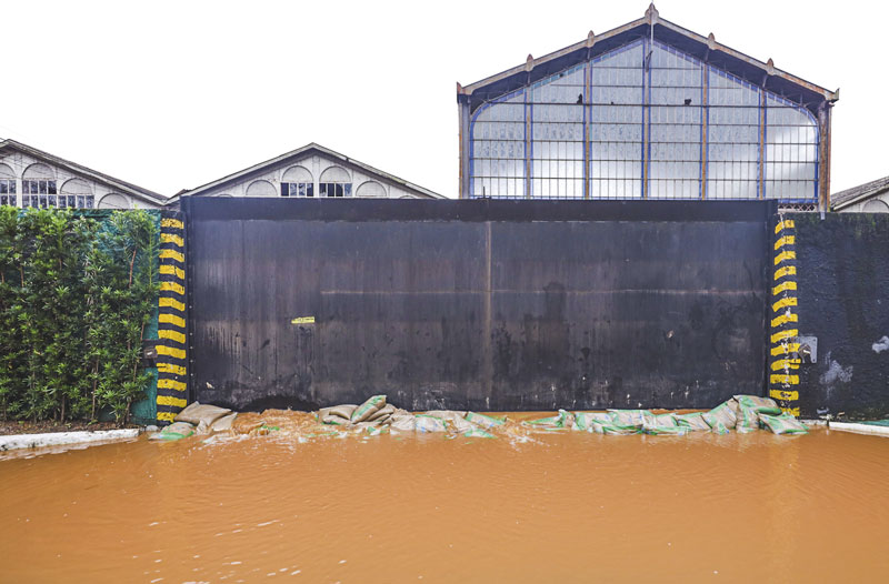
Giulian Serafim / PMPAWater from Lake Guaíba accumulating in Avenida Mauá, in front of one of the flood containment system gatesGiulian Serafim / PMPA
“In this case, there was a design fault,” states Tucci. “The 23 pumping stations should be fitted with flap valves, which close when the pumps are not working, preventing the lake water from entering the city.” Another default is the siting of the electrical systems for these stations. “Leaving the electrical part of this system below the floodwater level is not a good solution,” says Gomes, of UNISINOS. “One modification to look at now is raising these structures.”
The floodgates did not stop water from entering Lake Guaíba. “In many of them, there was no sealing between the metal plates and the concrete dike. They are different materials, and these seals require maintenance for effective function,” explains the researcher. Fan witnessed the failure. At the height of the flooding in May, he and colleagues from the institute visited some of these floodgates as soon as the rain stopped. “We saw at least one gate with a gap of some 20 centimeters. There was a sealing problem,” he reports.
Another issue is that the height appears not to be uniform along the full extension of the dikes. In the Sarandi neighbourhood, in Porto Alegre’s Northern zone, one of them was breached due to overtopping. “This occurs when water passes over the top of the dike and leads to erosion,” explains Fan.
Due to the high volumes of water buildup in the historic center, on May 17 the municipal authority had to knock down floodgate no. 3, on Avenida Mauá, to allow water discharge into the Guaíba. “We are now blocking this section with sandbags,” says Gomes.
His concern that the issue will be repeated in the future is well-founded. Climate models indicate that extreme events such as those afflicting Porto Alegre this year and in 2023 will increase in both frequency and intensity. “We know that, with climate change, there will be a reduction in the total number of extratropical cyclones, however there is set to be an increase in the most intensive ones,” says meteorologist Manoel Gan, a retired researcher at the Brazilian National Institute for Space Research (INPE). “A warm atmosphere stores more water vapor; more warmth generates even more evaporation, increasing water availability in the atmosphere. As a result, it will rain more intensively,” he says. The forecast is that events of this type will affect 1,942 municipalities across Brazil.
Researchers know that the cost of reducing damage is much higher than the investment required to prevent it. Tucci, of IPH, participated in a study commissioned by the Porto Alegre municipal government in 2023 to calculate the costs of revamping the city’s drainage and flood protection system. “It would cost R$4 billion to revamp the whole system; R$400 million alone on repairing the pump houses,” he affirms. After project execution, operation and maintenance of the system would cost R$200 million per year. The financial harm of not having yet carried out the revamp is being calculated, but should sit somewhere between R$6 billion and R$8 billion in the state capital alone, according to a report by news vehicle O Globo.
One action that may mitigate the problem going forward is to modify the urban territorial framework, with land-use planning to ensure permeable areas, earmarking of zones for water impoundments, and definition of permeability and sustainability requirements for the new projects. According to civil engineer Rodolfo Scarati, of the Department of Hydraulic and Environmental Engineering at the University of São Paulo’s Polytechnic School, there is no silver bullet to solve all the issues in urban areas. “Each water catchment behaves in its own way and demands a specific response,” he explains. Therefore, meticulous studies are needed so that known challenges can be anticipated. When there is a disaster, there are always issues that cannot be foreseen. “What we saw in Porto Alegre is still not, in statistical terms, the worst that can happen,” Scarati warns.
For Rauber, a detailed, integrated study of catchments is a pressing matter. He defends a structure responsible for sanitation, supported at federal level, encompassing all catchments. “Sanitation needs to stop being treated as the ‘ugly duckling’ of research. More studies are needed on urban drainage and flooding, and it is paramount that recommendations be properly followed.”
Republish