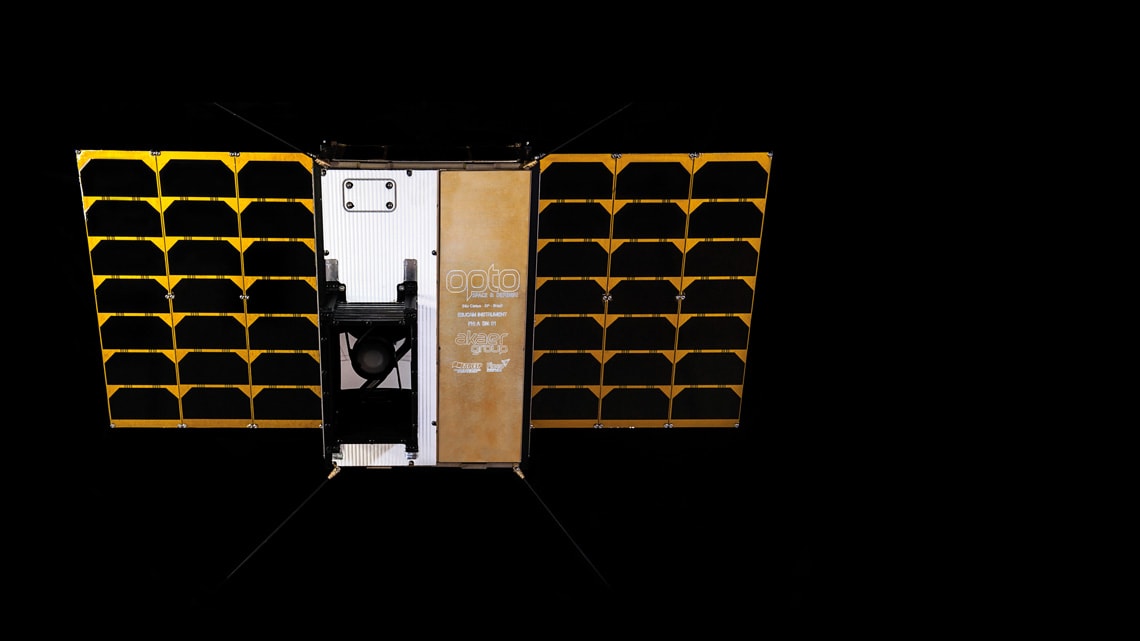
A space camera designed to take high-resolution pictures of Brazil’s national territory is being tested at the laboratories of the Akaer Group, an aerospace company based in São José dos Campos in the state of São Paulo. Named E3UCAM, the camera will be mounted on Earth observation satellite VCUB1, which is being built by Visiona Tecnologia Espacial, a joint venture between Telebras and Embraer’s Defence & Security division. If all goes as planned, the satellite will be launched into Earth’s orbit by mid-2020. It will be positioned 530 kilometers (km) from Earth and will fly over Brazil every 90 minutes.
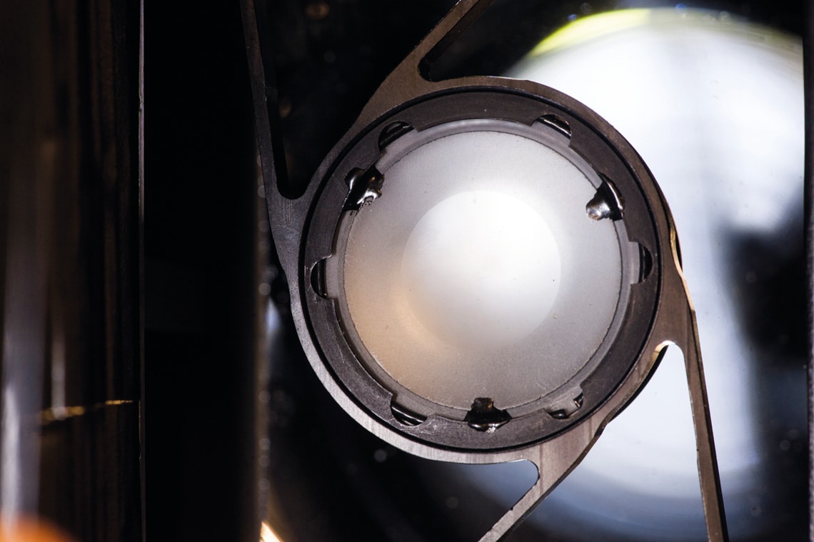
Work on the camera began two years ago by the engineering arm of Opto Space & Defense (formerly Opto Eletrônica) and Equatorial Sistemas, two companies in the Akaer Group. With an optical system formed of three mirrors, it will capture images of the Earth’s surface with a resolution of 3 meters (m)—in other words, each pixel (the smallest individual point that composes a digital image) will cover an area of 9 square meters (m2), clearly showing objects of certain dimensions, such as a pickup truck.
“The E3UCAM camera is an unprecedented development, representing a technological breakthrough for Brazil,” says materials engineer Fernando Ferraz, vice president of operations at Akaer. The device, he says, will produce higher-resolution images than current Brazilian satellites. Ferraz points out that the camera is an evolution of the previous model made by Opto for the China-Brazil Earth Resources Satellites (CBERS), launched over the last decade. “The MUX multispectral optical camera on these satellites has a spatial resolution of 20 m. We have improved the resolution almost sevenfold.”
The VCUB1 camera will be used primarily for environmental purposes, such as monitoring deforestation and supporting agricultural activities—similar applications to the MUX. “It will be an effective tool for detecting the start of new deforestation in the Amazon, something which is often associated with the creation of illegal roads. High-resolution cameras can be used to identify the emergence of these roads,” says electronic engineer César Celeste Ghizoni, executive director at Equatorial. “The new equipment could also identify smaller clearings typical of selective logging.”
More accurate focus
The development of E3UCAM was funded by FAPESP and the Brazilian Funding Authority for Studies and Projects (FINEP). Five projects approved as part of an agreement between the two institutions under the Technological Innovation in Small Businesses program (PIPE) were awarded a total of R$5.2 million. One of them aims to develop a mechanism for adjusting focus using temperature control. “The ground crew remotely heats or cools a device on the camera that controls its focus, enabling it to capture more accurate images. Most cameras embedded in satellites do not have this thermally controlled focus mechanism,” says Ghizoni.
The funds from FAPESP and FINEP were also used to enhance the camera’s digital data processing system. By developing compression algorithms, the researchers were able to increase the data transmission rate (in megabits per second, Mbps) by up to four times, making it easier to store and send images taken by the camera back to Earth. Lower file storage and higher transmission rates mean reduced power consumption, which is essential for satellites.
Another important feature is that the device can correct diffraction—an undesirable but common phenomenon that distorts images taken by space cameras. “We used a computational method known as deconvolution to improve image quality by reducing diffraction,” says Equatorial’s executive director, noting that the camera will provide images in four of the seven spectral bands (green, red, blue, and near infrared). A spectral band is the interval between two wavelengths in the electromagnetic spectrum. Using different spectral bands, which act like a kind of color filter, helps generate more detailed images of the landscape. Most cameras photographing Earth from space use these four spectral bands.
Miniaturization
Electrical engineer Marco Chamon, general coordinator of space engineering and technology at the Brazilian National Institute for Space Research (INPE), says one of the challenges when developing the camera was the need to miniaturize its systems. VCUB1 is a nanosatellite known as a CubeSat—a small, cube-shaped research satellite. It measures just 30 centimeters (cm) long, 20 cm wide, and 10 cm high. Smaller than a shoebox, the camera built by Akaer will occupy half of that space.
“Cameras on conventional satellites, like the CBERS, are huge and can weigh up to 150 kilograms [kg], while the one being built in São José dos Campos is just 3 kg,” says Chamon. “With such compact cameras, engineers have limited space to accommodate all the components, which means they face challenges that don’t exist with larger devices. In recent years, Opto and Equatorial have improved the design of these instruments, in terms of both the optical system and signal processing [transforming the optical signal into bits].”
According to Fernando Ferraz, the FAPESP projects were fundamental to Akaer’s development of the new technologies that enabled the creation of such a compact camera with a modular architecture designed for nanosatellites. Visiona is the first company to purchase the camera, which is also being offered to other interested parties in Brazil and abroad. The device costs around US$400,000 (R$1.6 million).
Few countries in the world are capable of developing high-resolution (like the E3UCAM) or “very-high-resolution” space cameras, which are capable of distinguishing objects on Earth smaller than 1 m in size. “Only a few countries, such as the USA, France, Germany, and China, currently have the means to produce these very-high-resolution cameras. That’s our next step,” says César Ghizoni.
Akaer’s camera is not the only technological innovation on Visiona’s nanosatellite. The satellite itself, the first to be entirely designed and built by a Brazilian company, is also an innovative design. According to the company, the satellite will serve as a platform for testing space technologies that could be used in future missions by the Brazilian Space Program, one of which is its attitude and orbit control system (AOCS), which includes the first satellite guidance software developed in Brazil. One of its purposes is to correctly and accurately focus the camera on the target area.
These systems are a sensitive technology, rarely shared between nations. “Having mastered this technology, Brazil is ready to create the first fully Brazilian satellite, thus integrating industry and academia in the high-tech sector,” said João Paulo Campos, CEO of Visiona, which is based in the São José dos Campos Technology Park.
Visiona’s nanosatellite program, which has a R$14-million budget, includes cooperation with INPE, which has vast experience in satellite development. The agency’s engineers provide support in areas such as systems engineering, assembly, integration, and satellite testing, among others. The company is also partnered with the Brazilian Agency for Industrial Research and Innovation (EMBRAPII), which partly funds the program, and the SENAI Institute for Innovation in Embedded Systems, based in Florianópolis in the state of Santa Catarina.
The latter was responsible for development of the ground station and the software that will integrate the onboard computer with various embedded components, including the optical camera. It also helped develop the sensors that will remain on Earth to receive data from the satellite. As well as the camera designed by Akaer, the VCUB1 satellite will be equipped with a system to collect hydrometeorological data such as rainfall, atmospheric pressure, and river levels.
New space
The VCUB1 is part of a new generation of small satellites that fall under the NewSpace philosophy, a global movement involving private space missions that are less expensive than in the past, when space exploration was conducted exclusively by national governments. Simple CubeSats cost just a few hundred thousand dollars, whereas a large conventional satellite requires investment in the hundreds of millions.
“There has been undeniable global growth in the use of CubeSats,” says physicist Luiz de Siqueira Martins Filho, from the Federal University of ABC (UFABC) in São Bernardo do Campo, São Paulo. According to him, CubeSats are democratizing access to space because they are cheaper and easier to manufacture, partly thanks to their use of off-the-shelf components such as sensors and processors. “Feats that used to be exclusive to major space agencies like NASA and the ESA can now be achieved by universities, businesses, and schools. CubeSats have grown in economic and technological relevance worldwide in recent years.”
Projects
1. Development of a TMA reflective optical system for orbital imaging instruments (nº 16/50142-4); Grant Mechanism Technological Innovation in Small Businesses (PIPE); FINEP PIPE-PAPPE Agreement; Principal Investigator Alexandre Lourenço Soares (Opto); Investment R$1,511,072.33.
2. Digital data processing electronics for remote sensor imaging instruments (nº 16/50150-7); Grant Mechanism Technological Innovation in Small Businesses (PIPE); FINEP PIPE-PAPPE Agreement; Principal Investigator Roney Ferreira Marzullo (Akaer); Investment R$1,262,247.00.
3. Focus-adjustment system using temperature control (nº 16/50148-2); Grant Mechanism Technological Innovation in Small Businesses (PIPE); FINEP PIPE-PAPPE Agreement; Principal Investigator Henrique Cunha Pazelli (Opto); Investment R$864,735.63.
4. Development of a lateral pointing system for an optical imaging mirror to be used in space (nº 16/50143-0); Grant Mechanism Technological Innovation in Small Businesses (PIPE); FINEP PIPE-PAPPE Agreement; Principal Investigator Daniel Moutin Segoria (Opto); Investment R$889,959.98.
5. Conception of the system for the EQUARS mission and microsatellite platform (nº 16/50167-7); Grant Mechanism Technological Innovation in Small Businesses (PIPE); FINEP PIPE-PAPPE Agreement; Principal Investigator César Celeste Ghizoni (Akaer); Investment R$744,250.00.
Republish