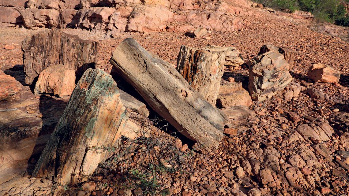
Of the 169 areas internationally recognized for their highly diverse rocks, geological structures and landforms, only one is located in Brazil. Araripe Geopark covers more than 3,400 square kilometers (km2) over six municipalities in the Brazilian state of Ceará and is home to petrified forests and an abundance of plant and animal fossils up to 150 million years old. Before the pandemic, it was visited by around 85,000 people per year. Geoparks are areas containing geological features of interest, known as geosites, and archeological, cultural, and educational attractions. They are also used for scientific research in fields such as geology, geography, archeology, paleontology, botany, zoology, ecology, and tourism.
And there could be other areas like this in Brazil. Geographers and geologists examined the country’s geodiversity—its range of rocks, landforms, and soils—and identified 36 areas that could one day earn Global Geopark status from the United Nations Educational, Scientific, and Cultural Organization (UNESCO). The sites include the town of Uberaba in Minas Gerais, known for its abundance of dinosaur fossils; the mountain ranges and saltwater lagoons containing fossils of 3-billion-year-old marine microorganisms on the coast of Rio de Janeiro; the mountain plateaus with deep valleys occupied by palm forests in Goiás and Mato Grosso; and the 120-meter-high rock walls that form the canyons of the São Francisco River between the states of Sergipe and Alagoas.
“In addition to their scenic beauty, these locations represent unique landscape formation processes,” says Jurandyr Ross, a geography researcher from the University of São Paulo (USP) and one of the authors of the article published in the journal Geoheritage in August that examines the 36 sites. The lead author, geographer Juliana de Paula Silva of the State University of Maringá, identified the territories with the greatest geodiversity based on maps drawn by the Brazilian Institute of Geography and Statistics (IBGE) and the Brazilian Geological Survey (SGB). She then cross-referenced the geodiversity map against a technical report issued by the Brazilian Society of Geology (SBG) in September on 36 Brazilian geopark projects at varying stages of development, finding that 18 of them have a high or very high geodiversity.
By overlaying the geodiversity map with conservation units run by the Chico Mendes Institute for Biodiversity Conservation, Silva observed that the areas with the highest geodiversity levels coincided with two environmental protection categories: wildlife refuges and natural monuments, with 43% and 38% respectively. “The diversity of landforms, rocks, and soils generates a range of environments and encourages animals and plants to adapt, leading to high biodiversity, as well as beautiful landscapes, such as waterfalls, caves, and mountain plateaus,” she says.

Francielle Garcia Moreira / Wikimedia
Fortaleza canyon in Cambará do Sul, Rio Grande do Sul, is part of the Caminhos dos Cânions do Sul GeoparkFrancielle Garcia Moreira / WikimediaDuring her doctorate, which she completed at USP in 2012, she studied Volta Grande do Xingu in the state Pará, an area with a variety of river formations, exclusive fish, amphibian, and reptile species, and a rich cultural diversity of indigenous peoples and river dwellers. According to Silva, the area, recently disfigured by the construction of the Belo Monte hydroelectric dam, was an exception that featured both high geodiversity and biodiversity. In the Amazon, geodiversity is mostly low.
“The surveys can serve as a guide for more in-depth field studies,” points out Maria da Glória Motta Garcia, a geologist at USP’s Institute for Geosciences (IGC). High geodiversity and geological heritage do not always coincide: “A place can have a high geodiversity by having a wide variety of rocks, geological structures, landforms, and soils, but a low geological heritage value if these rocks, landforms, and soils are common and insignificant.” Araripe Geopark, for example, has an average geodiversity rate, but its paleontological heritage is highly valuable.
In 2017, Garcia and her team presented 142 geosites in 81 municipalities in the state of São Paulo. The national survey, however, suggested just two geoparks in São Paulo because one geopark can cover many geosites—the one in Corumbataí has around 100. The USP team recently created an online map of the geosites and identified 57 with geological significance, described in the Journal of the Geological Survey of Brazil in June.
Conceived in France in the mid-1990s as a way of highlighting the importance of certain landscapes and geological formations, geoparks differ from nature parks and conservation units in Brazil. The first difference is the involvement of local residents, something which is rare or even unwanted in environmental reserves. “Input from public authorities is important, but public participation is essential,” says Marcos Nascimento, a geologist from the Federal University of Rio Grande do Norte (UFRN).
Bianca Manuela Lúcio Arcanjo / Wikimedia
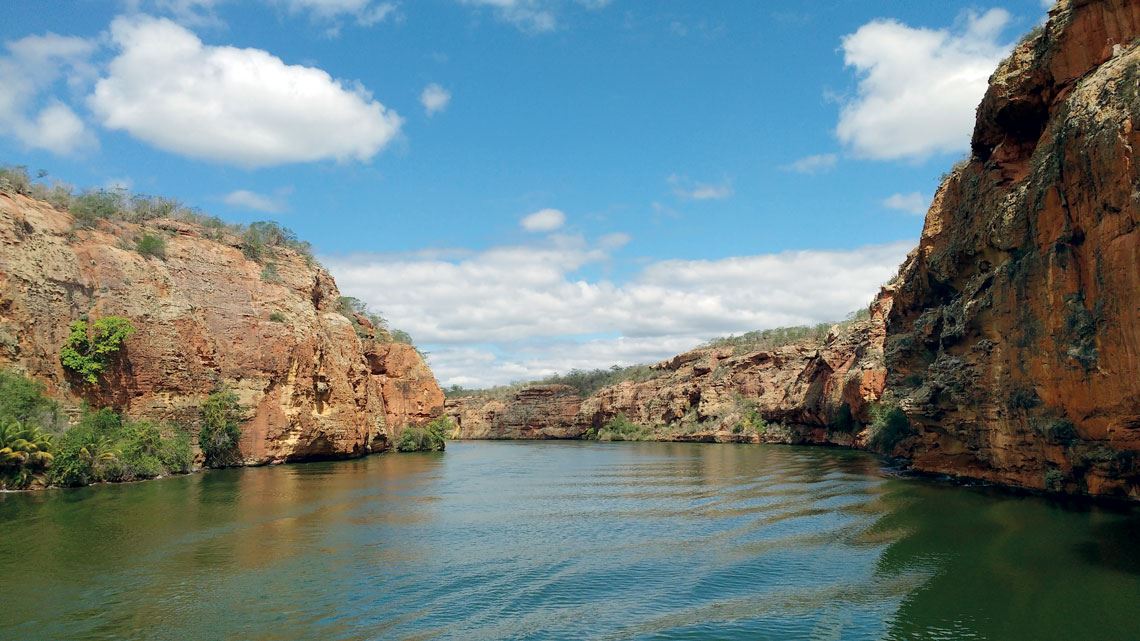
The Xingó canyon is part of the Cânion do São Francisco Geopark project, which spans parts of Bahia, Alagoas, and SergipeBianca Manuela Lúcio Arcanjo / WikimediaCreating a new geopark is a time-consuming process. In April 2010, Nascimento and a team from UFRN, in partnership with the SGB, arrived in Currais Novos to begin the first stage of the international recognition process: a geological inventory of Seridó Geopark, which covers 2,800 km2. “To earn geopark status from UNESCO, the region needs to have geological formations with international scientific value,” he says. In 2015, the researchers started talking to local residents, giving talks about the region’s natural wealth in schools, helping train tour guides, and stimulating the creation of craftwork cooperatives. Founded by UFRN, Seridó Geopark is managed by a public consortium of six municipalities that took two years to form, but it is not yet part of the global network.
“A geopark is essentially a form of land management designed to foster education, conservation, and tourism,” Nascimento says. They can encompass municipal, state, or federal parks, such as the natural rock sculptures of Vila Velha in the municipality of Ponta Grossa, Paraná, which became a state park in 1966. Including protection areas or conservation units is one of the requirements for joining the Global Geoparks Network.
Seridó is one of four Brazilian geoparks in the aspiring category, meaning it has already applied for UNESCO recognition. Another in the advanced stages is Caminhos dos Cânions do Sul, a 2,800 km2 area that spans seven municipalities in Santa Catarina and Rio Grande do Sul, featuring deep valleys, waterfalls, natural pools, and shelters excavated by animals 10,000 years ago.
João Matos, a physician and former mayor of the Santa Catarina city of Praia Grande, began managing the geopark, which encompasses two national parks, a state biological reserve, and several marine conservation units, in 2007. The area and number of participants were initially larger, before the current boundaries were adopted and management was handed over to an intermunicipal consortium, as reported by a group from the Federal University of Santa Catarina (UFSC) in a 2019 article in the journal Caderno de Geografia.

“A geopark should already be functioning, with a management system in place, before applying to join the global network,” explains Paulo Cesar Boggiani, a geologist from IGC at USP. This is the stage at which Uberaba Geopark, which is seeking recognition from UNESCO, finds itself. In June 2021, two life-size replicas of dinosaurs known to have once lived in the region—sculpted by artist Rodolfo Nogueira—joined several others already installed around the town, which is renowned for its abundance of fossils.
Boggiani helped draft the application for Bodoquena-Pantanal Geopark in the state of Mato Grosso do Sul. In 2011, UNESCO concluded that the site was not yet ready to receive certification because the extremely large area of 39,000 km2 was still unmanaged. “Implementing a management system is the biggest challenge,” notes Garcia. In the SBG survey, 74% of the 36 projects had no management plan, 65% had not formed a management committee, and 56% had not prepared any publicity material.
“The size of the area has to be manageable. Really big geoparks can be too difficult to manage,” explained USP geographer Isabella Maria Beil in a 2020 article in the journal NAEA Papers. A lack of funding and difficulties getting local communities involved and planning tourism and cultural activities are preventing geoparks from becoming more widespread in Brazil.
Over half of the world’s geoparks are located in Europe. The oldest are the Petrified Forest of Lesvos in Greece, Haute-Provence in France, and Vulkaneifel in Germany, all recognized by UNESCO in 2004. In April, it approved eight more in Denmark, Finland, Germany, Greece, Indonesia, Italy (with two), and Poland. The rest are distributed across Asia (40%), Latin America (5%), and North America and Africa (5%).
The global economic impact of geoparks is unknown, but a UNESCO team from Bangkok, Thailand, examined three of them in an article published in the International Journal of Geoheritage and Parks in June. Itoigawa in Japan received 90,000 visitors in 2019 and generated US$4 million in revenue. In the same year, Jeju Island in South Korea welcomed 15 million visitors, with revenues close to US$9 billion. Dong Van Karst Plateau in Vietnam, meanwhile, generated around US$4 million in revenue from 980,000 visitors in 2019.
Scientific articles
SILVA, J. de P. et al. The geodiversity of Brazil: Quantification, distribution, and implications for conservation areas. Geoheritage. v. 13, artigo 75, p. 1-21. 3 ago. 2021.
SUNG, C. L. et al. O processo de governança na construção do Projeto de Geoparque Caminhos dos Cânions do Sul – Brasil. Caderno de Geografia. v. 29, n. 59, p. 1043-63. out. 2019.
BEIL, I. M. Proteção da natureza e do patrimônio: uma análise sobre o conceito de geoparque. Papers do NAEA. v. 1, n. 3, p. 442-55. 2020.
RIBEIRO, L. M. de A. L. et al. The geological heritage of the state of São Paulo: potential geosites as a contribution to the Brazilian national inventory. Journal of the Geological Survey of Brazil. v. 4, n. 1, p. 45-54. jun. 2021.
LEE, Y. J. e JAYAKUMAR, R. Economic impact of Unesco Global Geoparks on local communities: Comparative analysis of three UNESCO Global Geoparks in Asia. International Journal of Geoheritage and Parks. v. 9, n. 2, p. 189-198. jun. 2021.
Report
NASCIMENTO, M. A. L. et al. Aspirantes e projetos de geoparques no Brasil em 2020. Natal: Comissão de Geoparques da Sociedade Brasileira de Geologia. set. 2021.