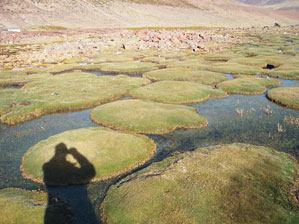
OTON BARROSFlooded gardens: small islands of organic material on the initial stretches of the Amazon in the Andes mountainsOTON BARROS
In a few weeks Paulo Roberto Martini will tell other geologists at a congress in Cuba’s capital, Havana, how he and his team from the National Space Research Institute (Inpe) concluded that the Amazon River is the longest in the world. Using satellite images and a field survey they saw that it is exactly 6,992 km long, 140 more than the Nile, which for centuries has been considered the longest. Martini will probably hear suggestions for adjustments to these measurements, but he will have no time to present the other discoveries about the way a river with many personalities functions, sometimes flowing fast and impetuous, sometimes slow and serene.
This is a river that is almost always exaggerated: it starts out as a trickle of water that runs among rocks 5,500 meters up, at a point close to a mountain known as the snow-covered Mimi, in the Peruvian Andes, forms monumental waterfalls and welcomes into its embrace the muddy, crystalline or dark waters of another 7,000 rivers. It is at the center of a catchment area the size of two Mexicos, which empties 3 million tons of sediment into the Atlantic every day, which is similar to eroding and carrying away a rocky outcrop like the Sugar Loaf Mountain, Rio de Janeiro’s most famous hill, in just one month.
“The Amazon is more than just a river”, Martini thinks, who along with his team learned to understand and admire the river while they were looking for its source. “It’s a living monument, a planetary agent.” For the time being the river, which apparently does not speak, can only hint at what it intends. In looking for the longest course possible for the waters of the Amazon and the Nile, based on the same image bank of two satellites, the Chinese-Brazilian Cbers and the North American Landsat, Martini noticed that the possible source of the Amazon is less than 250 km from the Pacific; it is as if it intended to unite the 2 oceans and tear South America apart.
The first waters start out already carving the steep rocks as soon as they come down off the Andes as melted snow. They run gently for the first 100 km, crossing almost desert-like Andean plains called Lloqueta and Ene. Further on they form a stream that grows bigger, seems to wake up and now with the name Tambo, becomes a river with rapids that boldly plunge from the top of the mountain. It continues on its winding way, now known as Apurimac, tumbling down more than 150 km of rapids and waterfalls. “The volume of sediment removed from the Andes and deposited in the Amazon basin makes this narrow valley one of the most eroded on the planet”, says Martini. The river then winds and meanders across the lowlands of the Amazon Forest, now with its name of Ucayali, ever more torrential as it gathers up the waters from other rivers. In Amazon – waters, birds, beings and miracles, poet Thiago de Mello presents this immense green plain, “ramified into thousands of liquid paths”, like a “magic labyrinth that unceasingly recreates itself from itself”. For Mello the Amazon is the homeland of water.
This is finally the Amazon we know: wide, sleepy and seductive. Now converted into a river of the plains it escapes from the immense Ucayali lake and moves eastward, entering Brazil with its new name, Solimões, which it keeps for a further 1,700 km until, after a long negotiation that begins in Manaus, the muddy waters reach an understanding with the Coca-Cola-colored waters of the Negro River, and from this the Amazon finally emerges. The calm river is still restless, because the skill with which it slides across such a flat landscape at 6 km an hour from Tabatinga, the first Brazilian city on its course, intrigued the Inpe team for a long time. “Because of its size it should be a lot slower”, says Martini who, after a lot of conversations with Valdete Duarte, Egídio Arai, Janari de Moraes and Oton Barros, to name just the closest of his colleagues, may have found an explanation for this.
They concluded that its narrow stretches control the river and make it run faster. Right after Tabatinga, the distance between the banks of the river is 2.2 km. A little later, just ten minutes away by boat, the river widens and the distance between the banks increases to 12 km. Lower downstream, three hours away by boat, there are more narrows in São Paulo de Olivença that are 2.5 km wide and then there are more and more, interspersed by wider areas, until the final narrow stretch in Óbidos, in Pará, that is just 1,800 meters wide between the banks and compresses an impressive volume of water, 200,000 cubic meters per second, enough to fill the Guanabara Bay in thee and a half minutes.
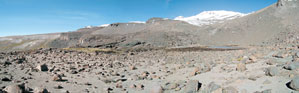
OTON BARROSBetween a precipice and a lake: the Amazon is beginning to form, 5,200 meters upOTON BARROS
Under orders from the Andes
“The river gets narrower and then spreads out, accelerating or holding back the waters, as if each of its own segments was a catchment area”, comments Martini. Formed by high rocks, the narrow stretches that define the course of the river function like valves in the veins that control the flow of blood in the human body. It was possibly when the geological bases of these narrows were being formed some 6 million years ago that the river reversed its course, which used to be in the direction of the Pacific, and headed towards the Atlantic, obeying new orders from the Andes that had started growing again, and in doing so changed the course of many other South American rivers.
Even in Brazil the Amazon is still an Andean river, rich in sediment brought down from the mountains to the east until it meets the waters of the Xingu, in Pará, already close to its mouth. Near the Marajó archipelago, formed by sediment from the Amazon, part of the soil from the Andes ends its long journey, plunges into the Atlantic and compresses the organic material of marine origin that in a few million years may be transformed into oil. If the sediment that is finer than sand falls into the ocean currents it may well end up 2,000 km away from the mouth of the river on the coast of Suriname, where it will fertilize rice plantations.
In the months when the Amazon is in flood and the waters rise by up to 18 meters on average the river invades the forest, makes the wood rot and releases a colossal amount of carbon dioxide, one of the gases responsible for global warming. “Some of the carbon that is missing may be generated on the river plains when the Amazon floods its banks”, says Martini, based on Nasa studies that indicate that every year the flooding of the Amazon generates 6 gigatons of carbon dioxide, the equivalent of 60 million dead elephants left to rot in the open air. In another phenomenon that is unique to this river the floodwaters infiltrate underground channels and make kilometers of land close to the banks subside by up to almost 8 centimeters because it is so saturated, according to measurements taken close to Manaus. Even the rocks that go to form the riverbed sink a little under the weight of the water.
From New York to Rome
Before being a candidate for the longest river in the world, which if it were placed in a straight line would stretch from New York to Rome, the Amazon was already the river with the biggest flow of water, which when added to that of its tributaries contains 20% of all the Earth’s fresh water. “There’s so much water that when we’re in the middle of the river we can’t see the banks. The waters of the Amazon rise on the horizon and we sink, as if we were in the sea”, says Martini, who is now 60 and who saw the river for the first time when he was 22, from the quayside in Belém, when he was still in the third year of his geology course. He thought it was the sea. But how can you not fail to be taken in by a river whose banks disappear into the distance, 10 km apart”
It was only 15 years ago that Martini decided to go in search of the source of the Amazon. He and his colleagues from Inpe also suspected that the point where the river started out was not in the north of Peru but in the south. Analysis of satellite images advanced to the point at which, in 1995, they indicated that the Amazon really was the longest river at 7,100 km, a little over 100 km more than the current measurement indicates, but after that things went more slowly because of a lack of time, people, money, equipment and information.
Two years ago circumstances became more favorable again. This was when the group from Inpe discovered an image archive from Nasa called Geocover, which helps analyze and correct satellite images and is used to map out deforested areas of the Amazon in association with researchers from Peruvian institutions. So Martini went back to reaching an understanding with the river and in May last year he was invited to take part in an expedition to the source of the Amazon that was organized by TV program producers, Paula Saldanha and Roberto Werneck, who had visited the headwaters of the Ucayali in 1994 and intended to go back again, now on a formal expedition with representatives from Inpe, the National Waters Agency (Ana), the Brazilian Institute of Geography and Statistics (IBGE) and the National Geographic Institute (IGN) of Peru. Martini had another commitment that prevented him from taking part, he remembered that going up into the Andes was dangerous (Janari de Moraes, an experienced mountaineer had died some months before while he was following an Inca trail in the Peruvian Andes) and even though he was passionate about the river he decided against going.
Two weeks later the person who set out for Peru in Martini’s place was another member of the team, Oton Barros, a 42 year old agronomist and amateur sportsman who cycles 50 km whenever he can. Because he had lived in Manaus from when he was 9 until he was 21 and had traveled along the Amazon he had always wanted to see where it started. But on his first adventure as a mountaineer, instead of the delight he was expecting, what he felt in the high Andes was permanent nausea and a slight hangover because of the altitude and because he had eaten very little in the three days he had taken to climb up there: almost all of the 20 members of the group had had diarrhea because they were not used to the food in the mountains, with its cream-based sauces. He was tense and tired because of the cold and strong wind. “This is an inhospitable place that inspires respect and fear”, Barros describes. Because of the oxygen-thin air, he felt as though his brain was working in slow motion.
The expedition helped establish consensus between the specialists from Brazil and Peru that the Amazon River rises on the slopes of the Ucayali River. The exact point where the waters start out on the longest journey of any river on earth may still take some effort to establish once and for all. “It’s very difficult to define which is the main water source since it comes from every possible direction and only becomes a stream some three kilometers lower down”, says Barros. The Peruvians have already established by law that the spring rises on a mountain-side called Carhuasanta, a U-shaped valley with a 300 meter wide base. Barros and the team from Inpe are still analyzing the possibility that the spring is on another mountain-side, the Apacheta, a kilometer away, which has a larger water catchment area, and turf and lichens that store the water all year long. This is a difficult dilemma: above Carhuasanta rises the snow-covered Mismi a mountain sacred to the Peruvians dating back to the time the Incas lived there.
Republish