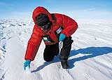
personal archiveThe glaciologist collects a sample of snowpersonal archive
At 4 o’clock of the morning of November 31 last, one day after having experienced the emotion (and the relief) of arriving at the geographical South Pole on board a motorized train pulled by a polar tractor, glaciologist Jefferson Cardia Simões decided to take a look, on his own and with more calm, at the landscape at 90° latitude south. In the midst of the inclement cutting wind of those whereabouts, which frequently causes a thermal sensation equivalent to -50°C, left the polar train and walked the 650 meters that separated him from the pole, passing, on the way, the Amundsen-Scott base. “Today, behind me, there is the immense American station, but as to the rest, a total void! Looking towards the immense and deserted plateau, where the most prominent features are small dunes (sastrugis) of 30 centimeters in height, some of the opinions of the explorers of the heroic period (the beginning of the 20th century) are quickly understood. Reaching here in 1912, Robert Scott exclaimed ‘Great God, this is an awful place'”, wrote, with good humor, in his diary, which is shortly to become a books, the 46 year old researcher from the Federal University of Rio Grande do Sul (UFRGS).
One of the leaders of the Brazilian Antarctic Program (Proantar), Simões, from Rio Grande do Sul, is the first Brazilian to reach the pole overland in a scientific expedition. He embarked on the adventure that took two months and US$ 3 million alongside 12 Chileans, who funded 95% of the costs of the mission – Brazil went in with 5% of the budget, granted by the National Council for Scientific and Technological Development (CNPq) and Petrobrás. The expedition covered about 2,300 kilometers. It went from the Chilean station at Parodi, already inside Antarctica, at 80° latitude south, up to the pole, and went back to the starting point. On the way, Jefferson took ice cores (cylinders) and snow samples.
“The glaciers are the best natural archives of the history of the environment”, explains Simões, who is married and has two adolescent children. For travelling so much to Antarctica, always in the summer, his family has now got used to not having him at home for the swapping of gifts at Christmas and the New Year’s supper. In this interview, the glaciologist talks about his experience in the world of ice, explains that Antarctica is not melting, and says that Brazil should look with more attention towards the white continent. “Ninety per cent of the Earth’s ice is in Antarctica. We are the seventh closest country to this continent. The ice is more important for Brazil than for the United States or Switzerland”, he says.
You have now been three times to the Arctic and 13 to Antarctica. Which was your most difficult expedition, the first one or the last?
An expedition’s difficulty is relative. In the first journeys, there is the curiosity of facing a totally different environment, of going, for example, onto a glacier. What used to be classroom theory becomes your day-to-day practice. Before going to the Arctic at the end of the 1980’s, where I did part of the fieldwork for my doctorate, I had only seen snow in England, which is not a good place for that. From inexperience, one incurs errors in a new and dangerous environment.
What kind of dangers?
There are several: the low temperature, which can lead to the freezing of the exposed parts, and frequently to hypothermia (an abnormal reduction in body temperature); very strong winds, of 170 kilometers or more; and the risk of falling into a crevasse in the glacier. In the Arctic, there is also the risk of bumping into a polar bear. We have to be always prepared for any situation and to have alternative escape routes in mind should any accident occur. In the polar environment, one sometimes commits more mistakes in perception than in action. There are hardly any colors there. Everything is white or in tones of gray. Just your clothes, a tractor is colored. I never forget how, when I returned from the Arctic for the first time and disembarked in Oslo, I thought that Norway’s capital was a tropical city. I arrived in spring, and Oslo was all green.
Have you ever fallen into a crevasse?
Three times, but I was always tied by ropes to other expedition colleagues, an essential safety procedure. Otherwise, if you are lucky, you’re going to fall into a crevasse and break some bones, but get stopped on some snow bridge down there. In other cases, very common, the guy falls headfirst, goes to the bottom, and death can be instantaneous. Or worse, it may take a few days, and the victim die of hypothermia. I have never been hurt. But that is a risk of the profession. The open cracks are frightening, but they are not an abyss. They are holes of 20, 30, or 40 meters at the most in the glacier. But, as we are not suicidal, they are not a problem. Falls happen when there are natural traps: snow bridges that form over the crevasse and hide the hole. You are walking over the snow, or skiing, and whoosh! The bridge breaks and the ground swallows you up. Tractors like the one we used on the crossing can also be swallowed up by the crevasses. To minimize this risk, we distribute the load well in the vehicle and in the sleds.
Are there no means of detecting a bridge over a crevasse a priori?
It’s sometimes possible with stakes, to probe suspect areas. But there’s a practical problem. You do this for 10 or 20 kilometers, but, on a long crossing, like the one we did, you can’t carry on like this for the whole journey. On this kind of expedition we use a radar and accept the risk. And we try to control the adrenaline.
Have you ever seen anyone being swallowed by a crevasse without being roped or die during an expedition?
Never. But when I was at Cambridge, I lost a classmate.
In the Arctic?
No. It was worse. It happened four months before he and I were to defend our doctoral theses. He was invited by the Russians to go to the border with China. A month and a half later, we received a telegram from the Russian Embassy, saying that he had fallen into a crevasse and died. It seems that he went for a walk alongside the tents of the camp without being roped, and fell to the bottom of a crevasse. Two months later, we received the body.
Do the majority of accidents occur from carelessness of the explorers or are they a fatality?
In polar research, however incredible it seems, the majority of the accidents happen at moments of recreation. The guy is not paying attention, he doesn’t obey the rules for survival, or fools around like he shouldn’t, like going for a run on a snowmobile over a frozen lake, and gets hurt. Another common situation that causes accidents: the guy drinks a lot of alcohol, leaves the tent, goes for a walk, sleeps in the open, and, on the following day, is found frozen. This kind of occurrence is well known. These cases are in all the manuals. How do I work on this question? I tell people to follow the rules and 90% of the problems will be avoided. Of course, even so, deaths can happen. It’s a risk of the profession, which you have to learn to deal with. At the same time, this is the playful aspect of my profession. While I’m doing science, I’m also doing geographical exploration where no one has ever been. That’s motivating.
Does the overland crossing en route to the geographical South Pole have scientific importance, or is it more a personal dream?
I can’t deny the aspect of the geographical exploration, of the historical feat. Even with all the present-day technological development, few countries have done a crossing of the continent, and less still a crossing to the South Pole. Getting a plane and going to the pole is expensive, but easy. Going over the mantle of ice is different. In South America, the Argentineans did an overland crossing to the pole, but it was a military expedition, on which they lost a tractor in a crevasse. The Chilean-Brazilian expedition was the first scientific crossing of Antarctica done by South Americans. The logistics for a polar expedition is no trivial thing. I have learnt a lot, and this knowledge will be important for future Proantar missions inside the continent. But the main objective of the mission was to generate knowledge about the evolution of the climate and the atmospheric chemistry over the last 400 years. The train that did the crossing was made up of a polar tractor, Swedish, pulling three closed containers. Coupled to the tractor was a container that carried all the fuel (kerosene). Next, there was a small trailer where we had a geophysics laboratory for carrying out the radioecho sounding, a technique for determining the thickness and the structure of the ice. Then came a large container that served as a laboratory, accommodation, cooking and a place for getting together. Finally, at the back of the train, there was a place for carrying crates and a bathroom.
How was the journey?
We went in planes of the Chilean Air Force from Punta Arenas, in the far south of South America, to the Chilean base at Parodi, located at 80° latitude south, by the side of the Patriot Hills. There, we disembarked over 20 tons of equipment for the expedition and assembled the train. From Parodi, we covered 2,300 kilometers with our motorized train. We went to the geographical South Pole in 47 days. During the crossing, most of us stayed in the container, and some drove the tractor. There was a curious aspect to the expedition, which shows Latin American reality. It was the first time in the history of polar exploration that the overland crossing to the South Pole had been done with only one tractor! When we reached the pole, the Americans, who maintain the Amundsen-Scott station there, asked us: “Where are the other tractors?”. We said that we didn’t have the money for a second tractor. The expedition was done at the limit of our financial resources. The tractor alone, with the containers, came to US$ 850,000. The vehicle, which could pull up to 25 tons (we pulled 22 tons) was a guzzler. It needed 4 liters of fuel to run for 1 kilometer. The excessive consumption almost left us on the road. We had to ask the Americans for a bit of fuel to guarantee our return to Parodi.
What were the scientific activities carried out during the crossing?
On the way out, we wanted to get to the pole quickly, and the journey took 16 days. The only scientific activity we did in those 1,150 kilometers was radioecho sounding. The radar that was on the tractor emitted continuously a pulse in the FM frequency that would go through the ice, hit the rock at its base, and return to the apparatus. We also placed stakes at some points of the journey, to measure the speed of the movement of the ice. On the way back, we left the American station on December 9, and reached the Chilean base on the 31st, shortly before the New Year. It was a journey that was a bit slower. That is because, every 10 kilometers, we would stop to collect surface samples of the snow, at a depth of between 10 and 20 centimeters.
Besides the 120 surface snow samples, every 220 kilometers we would take out an ice core from a depth of 50 meters at the most. In the course of the trip, we obtained six cores, totaling 220 meters of ice; the first of them, 33 meters long, originating from the geographical pole. Cores are cylinders of ice that we took out of the polar mantle with an electromagnetic drill. In Latin America, only us from the UFRGS have this equipment. We remove the cylinders and cut them into smaller pieces, a few centimeters long. Then we bag them, still solid, to avoid contamination. Next, we keep the cores in 32 reinforced polystyrene boxes, which house the material throughout the whole crossing. At the end of mission, the cores were transported to a commercial packing station in Punta Arenas. In May, a plane from the Brazilian Air Force is to bring them to Porto Alegre, where we are going to cut them into smaller pieces and send subsamples to Brazilian, Chilean and European laboratories.
What kinds of analysis can be done with the surface snow samples and, above all, with the ice cores?
The surface samples serve to determine the spatial variability of different chemical parameters of the snow. And the cores provide series of variations in time of these parameters. The snow is continuously precipitating and accumulating on the glaciers. The precipitated snow carries the characteristics of the atmosphere at the moment of the condensation of the crystal and impurities present during the precipitation. With the passage of time, the snow is transformed into ice, in a process called metamorphism. According to the characteristics of each place, with the temperature of the snow and other parameters, this complex process can take more than a century. So we have a natural archive that makes it possible to reconstitute the history of the Earth’s atmosphere even on a seasonal scale (with the seasons of the year). The wealth of detail comes from the dozens of chemical analyses that we can do with the samples of snow and ice. Information about the temperature of the atmosphere, for example, can be obtained by determining the ration of stable hydrogen and oxygen isotopes. The concentration of some ions, like chlorides, indicates the extent of the frozen sea in the past. The acidity of the snow and the content of microparticles help to identify volcanic eruptions with a global impact. Radioactivity measurements detect the impact of nuclear explosions. Variations in solar activity can be studied by measuring beryllium 10. Finally, air bubbles retained in the ice make it possible to define variations in the proportions and concentrations of several gases.
An ice core from Antarctica can contain information about climate from how long ago?
It depends on how much snow has built up at the place where the core was taken from. There is no rule. In the hinterland of Antarctica, one of the driest places on the Earth, the Russians keep a base, Vostok, where the annual accumulation of snow is about 2 centimeters. In a place like that, you don’t have to drill far to get a core with information of the climate of the last 10 thousand years. The deepest core from Vostok, from a depth of 3,623 meters, supplies climatic data for the last 420 thousand years. The oldest ice, aged 720 thousand years, was obtained from a core from 3,200 meters at the Franco-Italian station Concordia, also in Antarctica. Now, where Brazil has its research station, on King George Island, 1 meter of snow falls a year and the ice is no more than 360 meters in depth. There, it’s impossible to find any ice more than 5 thousand years old.
Should doing research in Antarctica be a priority for a country like Brazil?
Yes. Antarctica has a fundamental role in the interconnected network that the environmental system is. The continent’s mass of ice is the main energy “drain” on the planet. The greater part of the water from the bottom of the oceans is formed beneath the Antarctic ice platforms (the floating parts of the mantle of ice) or under the belt of frozen sea that surrounds the continent. The area covered by this marine ice in the Southern Hemisphere swings seasonally from 3 to 19 million square kilometers, which alters drastically the pattern of energy exchange between the ocean and the atmosphere in the course of the year. The inclusion of these processes in the general circulation models for the South Atlantic is essential for understanding the Antarctic control over the Brazilian environment and improving the weather forecasts. In short, for us to understand the Brazilian climate, we have to study both the Antarctic ice and the Amazon. We could give several other examples of the relevance of Antarctica, such as the question of the hole in the ozone layer, or the role of the biota of the Austral Ocean in the food chain of the South Atlantic.
I like saying that the Earth’s ice is much more important for Brazil than for the United States or Switzerland. Many people here still have the idea that ice and snow are things of the Northern Hemisphere. Except that Brazil is the seventh closest country to the largest part of the ice in the world. About 90% of the Earth’s ice is in Antarctica, and the remaining 10% is distributed over the Arctic and mountain glaciers. Closer than Brazil, there are only Chile, Argentina, Uruguay, South Africa, Australia and New Zealand. Our country will be one of the first to feel any changes in Antarctica. Perhaps the main difficulty for Brazilians is to understand the Dantesque scale of the volume of the Antarctic ice: it is as much as 25 million cubic kilometers. If all this ice were placed on top of our country, each Brazilian would have 3 kilometers of ice over his head. Should the Antarctic ice melt, the level of the sea would rise 60 meters. But there’s no way of this happening. The hypothesis is nonsense.
Isn’t global warming melting portions of the planet’s ice, in particular in Antarctica?
The ice from the outside edge of the Arctic, in island in the north of Canada and Siberia, in the south of Greenland, and, in particular, of the major part of the mountains in temperate and tropical regions, is melting rapidly. The situation in the Andes is now worrying, for the impact that it will have on the water resources of South America. In Antarctica, only the ice on the outside edge, on the Antarctic peninsula (the northernmost part of the continent) is melting. We do not know yet whether the ice in the hinterland of Antarctica is increasing or decreasing. All the mathematical models, though, indicate, that the global warming is going to increase humidity in Antarctica and make the ice in the hinterland become thicker, instead of reducing the volume. This same process, of an increase in the mass of ice, may be happening in the north of Greenland.
Adding up the forecasts for gains and losses of ice, according to the IPCC (Intergovernmental Panel on Climate Change), global warming is going to make the level of the sea rise between 15 and 100 centimeters in the next hundred years. An increase of 1 meter is frightening. It would have an enormous impact on the coastal defense and port structure. About 70% of this rise is due to the melting of glaciers. The other 30%, to the thermal expansion of the sea itself, another consequence of the increase in the temperature of the atmosphere. If it gets more heat, the sea expands. So be careful: the polar caps are not melting. It is some parts of the ice from the outside edges of the polar regions and, in particular, the ice from outside the polar areas that are.
So to say that Antarctica is melting is an exaggeration?
Yes. Antarctica’s area is 13.6 million square kilometers. A continent of this size does not respond in a homogeneous way to climatic changes, whether they are natural or artificial. This is the first point I’d like to emphasize. The second is that this immense mantle of ice, with an average thickness of 2,120 meters, but that can reach 5 kilometers at some points, covers 99.7% of Antarctica’s territory. And even more important than this: the major part of this ice is at a temperature far below the fusion point, at -30°C, sometimes -50°C. So it’s not going to be a warming of 2, 3 or 5°C in the temperature of the planet that is going to make great modifications in the ice of Antarctica. The hinterland of Antarctica is stable. Data from some research stations located in the hinterland of the continent indicate that there is even a cooling down of this ice. The ice of Antarctica tends to increase in volume, due to the intensification of the greenhouse effect. The press does not understand this.
What is the meaning of those large icebergs that have been breaking away from Antarctica in the last few years?
The formation of icebergs is something normal in Antarctica. As the snow never melts in the hinterland of the continent, there is only one way for the enormous mantle of ice to lose mass and maintain its size: releasing icebergs. The question here is simple. Is Antarctica as a whole getting rid of more icebergs than “normal”? We do not know yet. But this is happening in the interior of the mantle of ice, where 98% of the Antarctic ice is. In the Antarctic peninsula, the situation is different. This region is an appendix to the continent that points in the direction of South America and is only 900 kilometers from Tierra del Fuego. It’s a far milder place, where the ice is close to the fusion point of 0°C on the surface. At the Brazilian Antarctic station, on King George Island, to the north of the peninsula, the average temperature of the ice is -0,3°C. In the last 50 years, all the meteorological stations on the peninsula, particularly on the west coast, indicate an increase in the local atmospheric temperate of 2 to 2.5°C. On King George and on the South Shetlands, grasses are appearing, and animals that need lower temperatures to live are going more to the south. This regional increase, of 2.5°C, is much higher than the one seen in the average atmospheric temperature of the planet, which, in a hundred years, has increased 0.7°C. In these places on the outside edges of Antarctica, any energy applied makes the glaciers melt and causes a collapse in the coastal ice platforms. The platforms, which are supported by the water, are floating extensions of the glaciers of the continent. Since 1993, the area of the platform of ice lost in Antarctica is almost 15 thousand kilometers. It’s a lot of ice. But the ice from the platforms was floating, and, on Archimedes’ principle, its melting does not affect the level of the sea.
Has glaciology produced any proof that global warming is caused by human activity on the planet?
The deepest ice cores from Greenland and from Antarctica, which came from beyond 3 thousand meters, tell a rich story of the evolution of the climate of the planet in the course of the last 720 thousand years. During this period, we have had six glacial-interglacial cycles repeating themselves in a regular way. Glacial periods of roughly 100 thousand years, in which the climate keeps cooling down slowly, are followed by interglacial periods, which last between 10 and 20 thousand years, when the average temperature of the planet increases between 6 and 8°C. This information is derived from measurements of the ratios of hydrogen and oxygen isotopes that make up the snow and ice. Basically, during the warmer periods, the proportion of the heavier isotopes (deuterium and oxygen-18) in the polar snow increases. Several works of my colleagues, particularly from the glaciology laboratory in Grenoble, in France, who studied the air retained in bubbles in the polar ice, show that the concentrations of carbon dioxide (CO2) and methane (CH4) increase in the interglacial periods and decrease in the glacial periods. That is, there is a natural variation in the atmosphere of the concentration of greenhouse gases. This occurs because biological activity is intensified in the interglacial periods, increasing the production of CO2. But the same ice cores reveal another important fact: in 720 thousand years of the climatological history of the planet, the concentration of CO2 has never exceeded 300 ppmv (parts per million by volume). Today, the concentration is 380 ppmv, going towards 400. Also according to the cores, since 1780, following the Industrial Revolution, the levels of CO2 have increased 30%, and the levels of CH4, 100%. What am I saying with this?
That man produces the warming…
The answer is not so simple as that. On the one hand, we have undoubtable evidence that the increase in the concentration of greenhouse gases in the last 200 years can only have an artificial origin. Last century, the average temperature of the planet went up 0.7°C. On the other hand, we know, from data from meteorological and paleoclimatic stations that the climate varies spontaneously and at all the stages of time. During the interglacial period in which we are living, which began roughly 10 thousand years ago, we have had natural variations in the climate. Between the end of the Middle Ages and the end of the 19th century, what we call the Little Ice Age occurred, when the atmospheric temperature of the planet went down naturally by between 1 and 1.5°C. Afterwards, suddenly and very quickly, the temperature went up 0.7°C in a hundred years. As a paleoclimatologist, I accept that part of the global warming of the 20th century may be just a natural readjustment of the temperature of the planet after the Little Ice Age. But the evidences that there is an anthropic component (from human activity) in the warming are very strong.
Can the Kyoto Protocol put a brake on global warming?
Kyoto is not the final answer. It’s an attempt, a diplomatic effort. This problem is not going to be solved with a single decision. It’s childishness to think like that. The scale of values has to be changed, the manners of consumption, and the perception of what we want from life. With the current standard of consumption and today’s technologies, the planet cannot stand up for much longer. Some people are saying that the protocol is no use for anything. But it is of use. It’s a step, an example. Perhaps of large part of the Americans don’t give a damn for that, but it becomes difficult to behave like that if the rest of the world has a different opinion and attitudes.
The Americans say that the cost of implanting Kyoto is very high.
It’s not so big as all that if we reckon the costs of the environmental impacts that may occur from the lack of action. Kyoto is going to force the development of alternative technologies. They may not resolve all the problems, but they are already being implemented in some countries. Now I’m also not in favor of a radical ecology, which does not allow any modification at all in the environment. This is a totally idealized vision.
Why did you decide to specialize in the study of snow and ice?
I’ve always been interested by the environmental question, and I took at UFRGS with that hope of finding work after graduating. I think that everybody who opted for this career at the time was thinking of a job with Petrobras. During the course, I came in to contact with glacial geology, which is associated with glaciology, but it isn’t the same thing. Glaciology studies the forms of snow and ice, in particular the cryosphere, the present-day ice cover of the Earth. Glacial geology studies the results of the geological action of ice. Glaciology was then a curiosity for me. But when I was about to graduate, in 1982, I had the right idea at the right moment. Proantar was arising and getting ready to send the first Brazilian expedition to Antarctica, and I was looking for a job.
Did you go and ask for job in the program?
That was a time of economic crisis in the country. My Geology colleagues were not finding any work. So, in 1982, I contacted the people from the Antarctic program and said: “Look, you’re going to need a glaciologist, because over 95% of Antarctica is covered by ice”. In those days, it still wasn’t clear to many people that Antarctica influenced the climate of Brazil. But the CNPq had a program of scholarships for Proantar, for which I put myself forward as a candidate, and then I was sent to the Scott Polar Research Institute, of Cambridge University, England, a center of excellence in the area I chose. I did my doctorate there and became the first Brazilian glaciologist.
How was the return to Brazil?
It was the beginning of the Collar government, and, for a change, there was a recession. I only had a scholarship of a recently formed doctor from the CNPq. In this condition, I stayed a year at the Geosciences Institute of the University of São Paulo (USP). But, unfortunately, I soon saw that that there were serious restrictions on contracting personnel at USP, and I had to survive. I decided to go back home. I had the good fortune of seeing that, when I was returning to Porto Alegre, an entry exam was opened up for Geography at UFRGS. I passed in the entry exam and was able to launch my polar researches. In 1993, I created a laboratory that, today, has become the Antarctic and Climatic Research Nucleus (Nupac), where 32 people are involved.
Does Brazilian science carried out today in Antarctica have any international relevance?
Yes, we have projects of impact within the Scientific Committee on Antarctic Research (SCAR). During the last four years, with the implantation of two research networks involving over 20 Brazilian institutions, and with fresh financial resources from the Ministry of the Environment and the CNPq, it was possible to restructure and to improve the quality of the projects. There is no doubt that we are carrying out the best Latin-American scientific program in Antarctica. But the quality of research in Antarctica is still uneven. We have to have a lean and high quality Proantar, responding to questions directly connected with the interaction of the Antarctic environment with our country.