
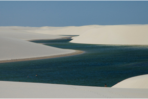
 EDUARDO CESARThe winding chains of sand dunes interwoven with temporary freshwater pools in Lençóis Maranhenses National Park take tourists’ breath away and intrigue researchers. After all, how have the sand, wind, and rainfall worked to sculpt and re-sculpt this sandscape over the past 10,000 years?
One would expect a complicated answer to such a complex question. So when a group of physicists achieved their first successful computer simulation of the dynamics of a Brazilian coastal dune field under the impact of rainwater, they were surprised to discover that the Lençóis Maranhenses field is apparently the product of a simple coincidence between the rhythmic annual rise and fall of the water table and the strong ocean winds that cause the dunes to grow and drift.
“We understand what special conditions give rise to the morphology of the Lençóis Maranhenses dune field,” states Eric Parteli, a physicist from the state of Pernambuco who specializes in dunes and who is currently doing post-doctorate work at Friedrich-Alexander-Universität Erlangen-Nürnberg (FAU) in Germany. He is one of the authors of a study published in the July 2012 issue of Geomorphology, along with German-Cuban physicist Hans Herrmann, who is with both the Swiss Federal Institute of Technology in Zurich and the Federal University of Ceará (UFC). Since 2001, work has been underway at UFC on a computer model that can simulate the wind and sand dynamics that shape and shift a broad gamut of dune types.
In the opinion of the article’s first author, physicist Marco Luna – who recently received his PhD from the UFC under the advisorship of Herrmann – the foremost benefit of these simulations is that they allow the rapid visualization of thousands of years of sand displacement, molded by wind and water. The model not only affords the opportunity to test hypotheses about the formation of coastal dunes but can help in the management of coastal regions as well. “One example would be evaluating the environmental impact of installing wind farms,” says Luna.
Located in the northeastern state of Maranhão, the Lençóis Maranhenses National Park is site of the largest dune field in South America, covering nearly 600 square miles – almost the same area as the city of São Paulo. The park is likewise home to a few rivers, mangrove swamps, permanent ponds, and some dunes stabilized by the scrub vegetation typical of the coastal sandy-soil ecoregion known as the restinga. But two-thirds of it are covered by migrating sand dunes, which can move almost four inches on a windy day.
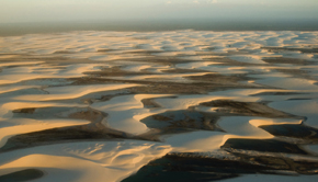
EDUARDO CESARReal and virtual: aerial view of dunes…EDUARDO CESAR
A flat beach varying in width from 0.4 to 1.2 miles stretches along the park’s 30-mile-long shoreline. Interlinked dunes rise 33 to 65 feet above ground, producing winding chains up to 46 miles long that advance inland for over 12 miles. These chains’ resemblance to crumpled bed linens gave the field its Portuguese name, Lençóis Maranhenses, which means “bedsheets of Maranhão.”
Unlike other deserts, the Lençóis Maranhenses receives relatively abundant rainfall, which can exceed 78 inches a year. Over 90% of this precipitation, however, falls between January and July, when quick absorption by the sand drives the water table above ground level, filling the seasonal ponds nestled between a patchwork of dunes. During this time of the year, the sand hills hardly budge due to high moisture and calm air. While the ponds may be about three feet deep in the rainy season, they dry up during the second half of the year, when the wind blows relentlessly from the east, gusting to over 43 miles an hour. “This is when the dunes move the most,” Parteli explains.
“Baby” dunes
In September 2003, Parteli, Herrmann, and other researchers spent six days at Lençóis, taking measurements for comparison with their computer simulations. They recorded how much sand the wind can transport, as well as the dimensions of the very smallest dunes – about 20 inches high – just after they are born on the beach. “There are few places where geological history can be experienced like this,” says Parteli. “Since Lençóis is such a large field, we can see all the steps in the evolution of a coastal dune, from birth to maturity.”

GOOGLE EARTH / LUNA ET AL, GEOMORPHOLOGY, 2012…, satellite view and computer simulationGOOGLE EARTH / LUNA ET AL, GEOMORPHOLOGY, 2012
The dunes migrate thanks to a phenomenon called saltation. It all starts when the wind blows hard enough to lift a few grains of sand off the ground. As the grains fall back to earth, they collide with others, causing them to spray upwards. The number of bouncing grains increases steadily until a cloud of sand up to six inches tall forms tight to the ground. If the wind always blows in the same direction, the dune takes on a crescent shape known as a barchan – that is, a mound of sand with two arms pointing downwind. Saltation makes sand accumulate on the sides of the barchan and pushes the grains to the top, where they slide down the other side like an avalanche. This is how barchans grow and shift, urged on by the wind.
By 2010, Herrmann and his colleagues had refined the model’s design so it could recreate the formation of barchans from winds propelling piles of sand across the beach. The first thing they discovered with their simulations was that a dune field will only come into being if the wind on the beach manages to carry as much sand as its power allows. “This is essential to producing the dunes,” Parteli explains. “The presence of a continental plate that always supplies more sand [dragged to the beach by the seawater] is also essential to the existence of the Lençóis dune field.”
During simulations, a number of “baby” barchans are born on the beach, one alongside the other; they then join to produce long, narrow configurations called transverse dunes, which resemble a series of waves in the sand, perpendicular to wind direction. As these transverse dunes pick up sand and advance inland, avalanching makes pieces of the sand waves crumble; they then detach and take the shape of larger barchans. Around half a mile from the coast, “adolescent” barchans stand over 15 feet tall. The abundant sands of the Lençóis field generate so many barchans that their arms meet, forming sinuous chains called barchanoids, which make up the “sheets” of the national park.
The computer-simulated barchanoids, however, did not display the same contours as those in the Lençóis field. The model still had to incorporate two elements that the researchers suspected were extremely influential to the Maranhão dunes: plantlife and rainwater.
Desert waters
In 2011, the researchers simulated coastal dunes using a model developed as part of the dissertation of Cuban physicist Orencio Durán, currently at the University of North Carolina at Chapel Hill, in the United States. Duran devised the mathematical equations that describe the struggle between the intensity of the sand-laden wind and the speed at which the restinga vegetation grows. He discovered that when plantlife grows fast enough, it can hold the arms of the barchans in place. As a result, only the body of the dune continues to move; eventually, it acquires a form called a parabolic dune, whose arms point into the wind. Although there are some parabolic dunes at Lençóis Maranhenses National Park, the simulations have made it clear that vegetation has hardly any influence on shifting dunes.
 Computer simulation only yielded something truly similar to the Lençóis field when the researchers included the annual cycles of the water table and the wind in their model. They discovered that during the rainy season, the temporary ponds between the chains of dunes soften and elongate the curves of the barchanoids, producing the shape found at Lençóis. Water also limits the growth of barchans to a height of roughly 65 feet. If there were no ponds, the dunes would tend to grow indefinitely as they marched inland. The ponds in the simulations resemble the waters of the Lençóis field; they display the same maximum depth (three feet on average), cover approximately the same area, and likewise come in various shapes and sizes.
The researchers experimented with two parameters in the model: the amount of precipitation and the length of the wet and dry seasons. They observed that the simulations only generated sheets of sand alternating with ponds when the rain fell in the same amount and with the same periodicity as in the Lençóis field. If the ponds did not last as long or if they covered a smaller area, the landscape would be entirely different, composed of taller, amorphous dunes. If, on the other hand, the ponds were larger and more stable, the result would be a plain of sand instead of dunes.
According to Parteli, there is a physical explanation for this fact. The model’s equations indicate that the dune chains and the ponds can only intertwine in such a regular fashion if the period of fluctuation in the water table coincides with the time it takes for the dunes to advance downwind a distance equal to their width. At Lençóis, this time is just about a year.
Despite the model’s success, Parteli believes it still needs further refinement if it is to provide more precise quantitative results. The description of the wind between the arms of the dunes, for example, is still quite simplified and may affect the exact shape of the dunes. Parteli hopes to include more details in the simulations, such as variations in the park’s relief and in the quantity of sand available along the coast. “This is the only way we’ll be able to use the model to predict the future of the Lençóis field,” he says.
“It’s a fine study, but based mainly on theory,” notes dune expert Haim Tsoar, of Ben-Gurion University in Israel, who has conducted studies on the Lençóis field. “It could be improved through more field work to corroborate their conclusions.”
Scientific articles
LUNA, M.C.M. et al. Model for a dune field with an exposed water table. Geomorphology. v. 159-60, pp. 169-77. Jul. 2012.
LUNA, M.C.M. et al. Model for the genesis of coastal dune fields with vegetation. Geomorphology. v. 129, pp. 215-24. Jun. 2011.