
orbitalSolar panel made by the Orbital company. The panel will supply the energy to the satelliteorbital
At the beginning of September, the eyes of all the engineers and technicians of the Instituto Nacional de Pesquisas Espaciais/Inpe (the National Space Research Institute) will be focused on China. Many of them will be in China, following the launch of the third CBERS, China-Brazil Earth Resources Satellite, a cooperative project between Brazil and China. The artifact will go up to space on board the Longa Marcha 4B space ship, scheduled for launching from the Taiyuan Satellite Launching Center, in the Chinese province of Shanxi, 800 kilometers away from the capital city of Beijing. The new satellite, named Cbers-2B, is very similar to the previous satellite, the Cbers-2, which has been in orbit since 2003, and has already exceeded its estimated two-year useful life. The launch is a step forward in the Cbers program, which began in 1988, when the two countries signed an agreement of cooeration for the development, manufacture, testing, launch and operation into orbit of two identical sensor-remote satellites. The first Cbers-1 was launched in October 1999, stopped working in August 2003, and was substituted by the Cbers-2.
A new agreement was signed in November 2002, with the objective of continuing the program. The new agreement provided for the construction and launching of two more satellites, the Cbers-3 and 4. The Cbers have allowed Brazil to join a select group of nations able to collect images of the Planet and monitor their own territories. Brazil is responsible for 30% of the manufacturing of the equipment and components of the 2B satellite, a task that involved the work of 12 small and medium-sized Brazilian companies. Brazil will become more involved in the next two satellites, as is provided for in the agreement, and will be responsible for 50% , half and half with the Chinese.
“The Cbers-2B was built with spare parts left over from its predecessor. It will be launched to cover a gap and to avoid the discontinuation of the service that provides images of the program, because the next satellite in this series will only go up to space in two years”, says electronic engineer Ricardo Cartaxo, coordinator of the Cbers project at Inpe, an entity of the Ministry of Science and Technology which is responsible for the project in Brazil. According to Cartaxo, recycling most of the subsystem projects – the parts that a satellite is divided into – developed for Cbers-2 allowed some time to be saved for the launch and, at the same time, saved on manufacturing costs. Brazil invested US$ 15 million, including the value of the launching, while the total cost, for Brazil, of the first two satellites, came to US$ 118 million.
Free distribution
An important characteristic of the Cbers sensor remote satellites is the fact that they are equipped with several cameras for the observation of the entire terrestrial globe, with different spatial resolutions and specter bands (electromagnetic waves captured from the earth), in addition to a system that collects environmental data. The images are used in various applications, such as the control of deforestation and cutting and burning in the Amazon Region, the monitoring of water resources and of farm regions, and the tracking of urban sprawl and land occupation. The distribution is free of charge and was adopted in June 2004. Approximately 340 thousand images of Brazil’s territory generated by the Cbers-2 were already distributed at no cost to 15 thousand users from 1,500 Brazilian institutions, among which are universities, research institutes, government entities, NGOs and private sector companies. “We are the biggest distributors of free images in the world”, says Cartaxo. In May 2006, the Inpe began to offer, also at no cost, images to South American countries within the region covered from the receiving and recording station located in the city of Cuiabá, State of Mato Grosso. “With the 2B, we intend to start distributing images at no cost to African countries. To this end, we need to make some changes at the receiving stations located in South Africa, on the Canary Islands, and northern Africa”, says the engineer from Inpe.
The earth’s orbit, synchronized with the Sun, allows the satellite to obtain images at an altitude of 778 kilometers. The Cbers-2B will cross the Equator every morning at 10h30 a.m., which will allow the comparison of images captured on different days. The satellite will revolve 14 times around the Earth every 24 hours and will be able to cover the entire planet every 26 days. This is possible because it goes around the earth in 100 minutes covering a strip of approximately 120 kilometers every time it travels from North to South. As it takes the Earth one day to revolve around its axis, the satellite’s next path, 100 minutes later, will have passed over a point in the Equator and the satellite will have traveled 2,700 kilometers. At the end of the 26-day period, the satellite will have covered the entire planet, even though some cameras have a smaller resolution, of up to a 27- km band, which increases the time it takes to photograph the entire planet.
A new High Resolution Camera – HRC – is the main novelty that the satellite will be equipped with. The HRC produces very clear images in a 27-kilometer wide band and a resolution of 2.7 meters. Built by the Chinese, it will allow for a highly detailed view of the Earth’s surface. Every 130 days, it will be possible to have complete coverage of the country. According to agronomist José Epiphânio, coordinator of the Inpe’s Cbers applications program, the images generated by the HRC will have a number of uses, among which is the generation of national mosaics and detailed studies, the updating of maps, the generation of products for local or city planning, as well as urban and intelligence applications. “The equipment, which will operate experimentally, will work like a zoom and will substitute the Medium Resolution Image Scanner/MRSI, installed on board the Cbers-1 and 2. The MRSI produced images of a 120-kilometer strip and 80-meter resolution. This is equivalent to 120 kilometers of land being divided into small parts (each image) of 80 meters. Thus, the smaller number of meters, the better the spatial resolution will be and more details will be seen”, says Epiphânio.
In addition to the HRC, the Cbers-2B will also be equipped with two other cameras: the Wide Field Imager (WFI) and the High Resolution Imaging Camera (CCD). Also designed and developed in China, the CCD will provide images of a 113-kilometer strip with a 20-meter resolution. As an example, if we were to take any map with a scale of 1:100.000, in which each centimeter on the map is equivalent to one thousand meters of land, each 0,2 millimeter (mm) would represent a 20-meter resolution pixel. This equipment will operate in four spectrum bands (blue, green, red and near infrared), plus a panchromatic spectrum, and will be able to guide the field of vision (the part of the land visualized by the camera) within approximately 32 degrees in relation to the satellite’s regular path. This will result in stereoscopic images of a specific region for map-making purposes. The WFI camera was built in Brazil by the Equatorial Sistemas Company, located in the city of São José dos Campos, State of São Paulo. It has a field of vision of 890 kilometers and produces images with a spatial resolution of 260 meters. Because of its broad spatial coverage, one will be able to obtain a full view of the globe every five days. The camera will be used to track farming harvests and cutting and burning, and to monitor vegetation, among other uses. The Cbers-2B will be very well equipped in terms of cameras and will be able to view narrow strips of land (2 km in the case of the HRC) and wide strips (890 km in the case of the WFI). It will also be able to view objects in great detail (2.7 m with the HRC and 20 m with the CCD).
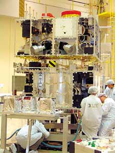
inpeThe satellite was assembled at the Inpe laboratories in São José dos Camposinpe
Environmental data
The Cbers-2B also carries repeat equipment on board for the Brazilian Environmental Data System. This equipment was manufactured by Neuron Eletrônica, another company located in the city of São José dos Campos. The company was established in 1993 to design and develop equipment for the Brazilian space program. This equipment has more than 750 data collection platforms on the ground; these are small automatic stations normally installed in remote places in different regions of the national territory. They send environmental data to the satellite, such as rainfall index, atmospheric pressure, solar radiation, temperature, air humidity, speed and direction of the wind. This information is then re-transmitted by the satellite to the INPE’s ground stations in the city of Cuiabá and in the city of Alcântara, State of Maranhão. This data is used for weather forecasting, studies on ocean currents and tides, and agricultural planning.
Another innovation in the Cbers-2B satellite is the digital data recorder, which is more powerful then the two versions which equipped the two earlier Cbers . “Previously, the recorder only taped the images of the CCD and now it will tape images from the three cameras”, says electronic engineer Jânio Kono, coordinator of Inpe’s space department. The recording will allow images of any part of the world to be stored after they are downloaded when the satellite flies over a ground reception station. In addition to the WFI camera and the repeater devices for the environmental data collection system, placed in the module of the satellite referred to as “useful cargo”, a group of Brazilian companies was asked to develop three other subsystems, namely, the structure, power supply and part of telecommunications, to be part of the service module.
Systems and controls
The service model houses the equipment that moves the supply of power, the controls, telecommunications and other necessary functions for the satellite’s operations. A pool of companies led by Akros, from São José dos Campos, and Digicon, from the city of Gravataí, State of Rio Grande do Sul, manufactured the structure of the satellite, while Omnisys Engenharia, from the city of São Caetano do Sul, in São Paulo’s metropolitan region, developed the altitude and orbit control subsystem and the On Board Data Handling, a computer that controls the satellite’s functioning. Tectelcom, Beta Telecom and Neuron, all from São José dos Campos, developed the equipment for the telecommunications module, while the power supply system was developed by Digicon and Aeroeletrônica, two companies from the State of Rio Grande do Sul, and by Orbital Engenharia, from São José. This company won the bid for the construction of the solar panels, also referred to as photo voltaic generators.
“We won two bids related to the Cbers-2B, at an approximate amount of R$ 4 million. The first bid was for the supply of solar modules, the main component of the panels. They had previously been imported from Germany. The other bid was for the assembly of the modules on the panels’ structure. This was the first time that the electric part of the panels was entirely built in Brazil”, says mechanical engineer Célio Costa Vaz, a director of Orbital. The satellite has three solar panels, each one 1.7 meters wide and 2.6 meters long. These panels capture the solar radiation and convert it into electricity. “The tools, the equipment and all the manufacturing technology were developed and qualified by the Inovação Tecnológica em Pequenas Empresas/Pipe (Technological Innovation at Small Companies) program run by FAPESP”, says Vaz (see Pesquisa FAPESP nr. 99). According to the engineer, in addition to generating new jobs and providing technological independence, the local manufacturing of the panels allows the Inpe to save between 15% and 25%. In addition to Orbital, six other companies – Akros, Omnisys, Equatorial, Neuron, Beta Telecom and Opto – that participated in the Cbers project are working on other projects (some not specifically related to the satellite) funded by Pipe.
All the assembly, integration and tests of the Cbers-2B, whose mass corresponds to 1,500 kilos, were conducted at Inpe from September 2006 to April 2007, when the satellite was sent to China for the final touch-up before the launching. Before the 2B goes up to space, the new version that will substitute it is already being developed. Scheduled to start orbiting in 2009, the Cbers-3 will have various changes compared to its predecessors. The Brazilian participation in the project will increase and half of the satellite’s subsystems will be made in Brazil. “The development and manufacturing of the Cbers-3 and 4 satellites, which are the same, represent contracts of approximately R$ 235 million for Brazilian companies. The value seems to be high, but one only has to look at the variety of applications and the number of people using our images, not to mention the impact on the development of Brazil’s industry, which is now involved in the manufacturing of high-tech products”, says Ricardo Cartaxo.
The Cbers-3 and 4 – the latter is scheduled for launching in 2012 – represent an evolution of the previous satellites. “They are part of a new family, of a more contemporary concept”, says Jânio Kono. The two satellites will be bigger, approximately 2 thousand kilos, and will have new applications. The solar cells of the panels will be more efficient, with 26% conversion from sun energy into electric power, whereas in the 2B this proportion comes to 14%. “This will allow for more subsystems to be fed, which means that they will be able to carry more useful cargo”, says Kono. The satellite will carry four cameras on board – one more than the earlier satellites carried. Two of the cameras (MUX and AWFI) will be made in Brazil, while the other two (panchromatic and the IRMSS) will be made in China.
Updated version
Designed and manufactured by the Opto-Eletrônica company from the city of São Carlos, State of São Paulo, the MUX is a multi-spectrum camera with 20 m resolution and a visual field with a width of 120 kilometers. The camera generates images in four spectrum bands, from blue to near infra red. It will be used for environmental monitoring and the management of natural resources. According to Inpe engineer Mário Luiz Lingardi, technical manager of the MUX Project, this will be the first camera with these features to be entirely developed and made in Brazil. It was designed to replace the CCD, which was in the Cbers- 1 and 2, having gone through the first battery of tests throughout 2006.
The other Brazilian-made camera will be an updated version of the WFI of the Cbers-2B, which is being jointly manufactured by Opto-Eletrônica, responsible for the optical features, and by Equatorial Sistemas, which will work on the mechanical integration and the components for the processing and sending of images to the ground stations. The camera will cover an area of 866 kilometers with spatial resolution of 73 meters, in comparison to the 260 of the earlier version. Thus, the camera will be able to view more details, even though it will still be the same distance from the Earth.
“This is a highly advanced project in optical and electronic terms. To give you an idea, the equipment will weigh approximately 40 kilos, in comparison to the 5 kilos of the earlier version”, says mechanical engineer Humberto Pontes Cardoso, responsible for the project Equatorial. At this time, the company is building the engineering model to qualify all of the camera’s functional part and the mechanical model to validate the structural and thermal designs. This stage will have been concluded by the end of 2007 and will be followed by the production of the qualification model, after which it will be submitted to environmental and electromagnetic compatibility tests. “It is very important for Equatorial to take part in the Cbers project. The manufacturing of the new WFI has brought us a number of challenges, from the development of the electronic part to the integration and testing procedures, which are also our responsibility”, points out Cardoso.
Omnisys Engenharia is another company deeply involved in the project. It will be responsible for the altitude and orbit control system and for the On Board Data Handling computer, that equip the service module. “We will also design and build the data collection system (DSC) and, in partnership with Neuron, we will make the MWT subsystem, which will transmit the data to the MUX and WFI cameras”, says electronic engineer Luiz Henriques, the president of Omnisys. “These are highly complex projects in which the company exercises its technical and technological competence to the highest degree”, says Henriques. The company is already manufacturing the qualification models of the two computers, for altitude and orbit control and for the On Board Data Handling. The other two projects are still at a preliminary stage, the critical review, which comprises a detailed assessment of the adopted solution. Omnisys’ contract with Inpe totals approximately R$ 41 million, corresponding to 40% of its revenues.
In addition to partnering with Omnisys, Neuron is building a telemetric subsystem jointly with Mectron Engenharia and Beta Telecom, both from São José dos Campos. This system will be responsible for the communication between the satellite and the ground stations. “We were deeply involved in the first phase of the Cbers project and this helped us to land the contracts to take part in the Cbers-3 and 4 projects. I believe that our technical competence was crucial in beating our competitors”, says electronic engineer Claudemir da Silva, partner-director of Neuron. In his opinion, the fact that Neuron is part of the pool of companies involved in the project automatically prepares it to take part in outer space projects in other countries. “Our objective in the medium term is to offer our services on an international level”.
Republish