
GUILHERME GAENSLY / IMSThis was the Tietê and the yacht club in São Paulo in 1915.GUILHERME GAENSLY / IMS
Every year at this time, when the rains are heavier and more frequent, the rivers and creeks of the city of São Paulo become visible and we are reminded of them when they thrust out to the streets the excess water they can no longer carry. Rivers are simply responding to the way in which they have been molded over many decades. “People say that a river that washes everything away is violent, but no one says the banks that compress them are violent,” wrote German playwright Berthold Brecht. Most of the rivers that crisscross Brazil’s biggest city have been compressed and hidden in concrete tunnels under broad avenues. Some of them have had their courses redrawn—“corrected,” as engineers would say—and can no longer be thought of as an alternative opportunity for a pleasant weekend outing.
The transformation of São Paulo’s rivers was an intense and rapid process. At the beginning of the 20th century, the city’s residents amused themselves on Sundays by swimming, fishing, or boating on the Tietê River, along whose banks were clubs, restaurants, and picnic grounds. Those pleasures ended with the increase in the amount of waste discharged by homes and businesses into the river. By the 1950s it was already, as it is today, an open sewer, revealing a careless attitude toward nature and indifference to the esthetics of Brazil’s wealthiest city. Since 1995, the effort to clean up the Tietê, the main river that crosses the city, has consumed the equivalent of $1.6 billion and reduced the extent of the pollution, which had been evident as far away as Barra Bonita, 260 km from the capital. Now the pollution goes only as far as Salto, 100 km away, but it has not stopped. In April 2013, the governor of São Paulo announced the third phase of the Tietê River cleanup program, which calls for $2 billion in investments. If all goes well, the percentage of sewage collected will increase from 84% to 87%, and the percentage treated from 70% to 84%, both in 2016. Another R$439 million was spent from 2007 to 2013 to clean up 137 of the 300 creeks in the metropolitan area. It is estimated that 7 kg of wastes are discharged every second into the rivers and creeks of Greater São Paulo, which people still see as a convenient place to dispose of not only residential and industrial wastes, but construction debris, plastic bottles, sofas, tires, and old cars.
“São Paulo has suffocated its rivers,” is the way that engineer and attorney Rodolfo Costa e Silva sums up the situation. He is coordinator of the programs to clean up the Tietê and improve the ring roads around the Tietê and Pinheiros rivers. “We want to clean up the rivers and keep them clean,” he says. “It’s both a water-related and urban development process.” The programs he coordinates have recruited the participation by municipalities in Greater São Paulo, companies and NGOs. Plans call for building bike paths, sidewalks and parks along the 50 km of highways and navigation routes on the rivers, and would go so far as connecting the Congonhas and Guarulhos airports by boat.

Eletropaulo collectionA photo of Avenida Leopoldina, the banks of the Pinheiros River, in São Paulo during the February 1929 flood.Eletropaulo collection
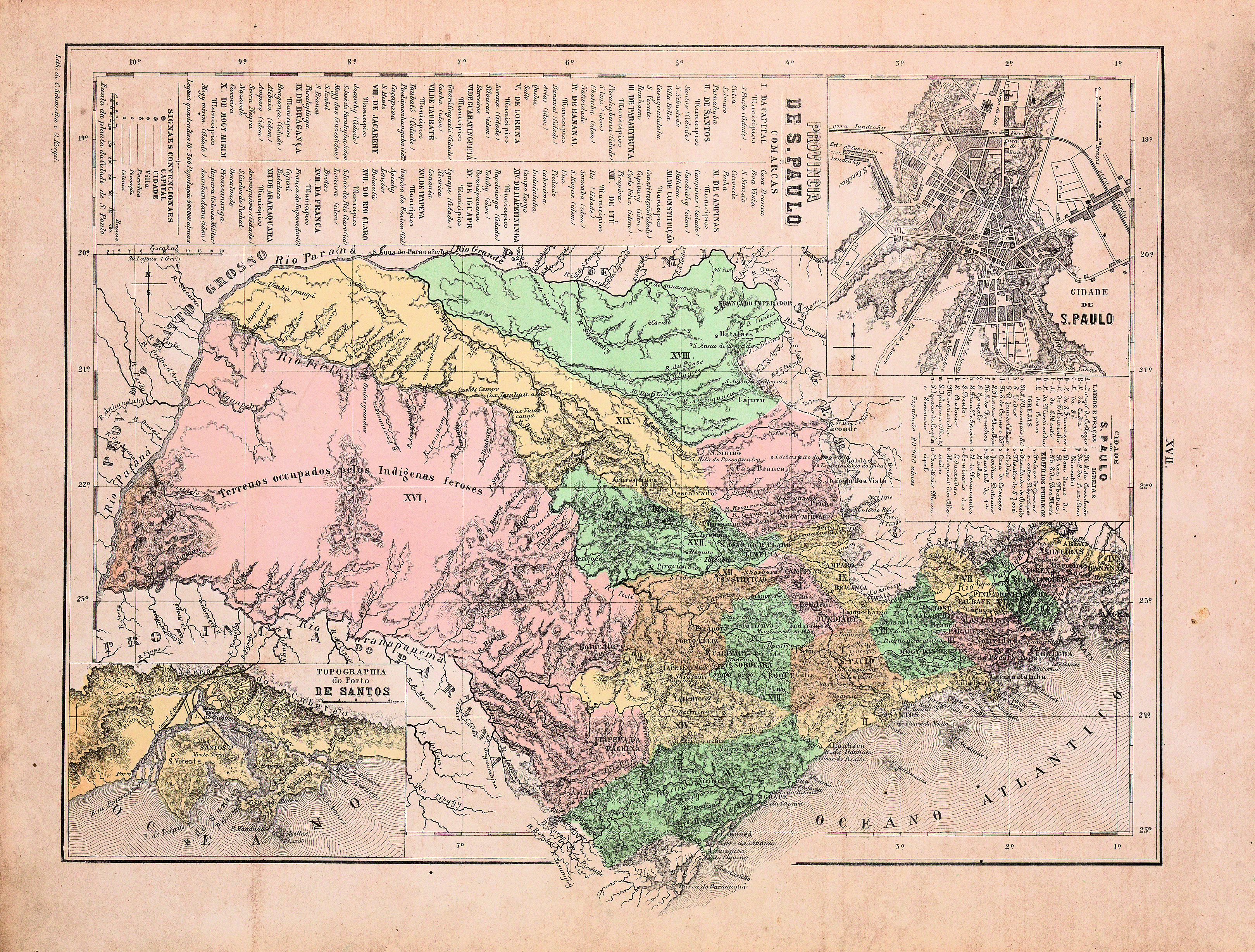
The city of São Paulo, with its mistreated rivers, “is an example of what can happen when the decision-making authority is concentrated in the hands of just a few powerful groups,” says historian Luis Ferla, a professor at the Federal University of São Paulo (Unifesp). A native of Curitiba who has lived in São Paulo since 1992, Ferla was one of the curators of an exhibit entitled O tempo e as águas: formas de representar os rios de São Paulo (Time and the Waters: Ways of Depicting the Rivers of São Paulo). It will be open until March at the Public Archive of the State of São Paulo. It includes 17 maps (several of which are reproduced in this article and on this magazine’s website), as well as photographs and notebooks containing the records of fieldwork done by engineers and cartographers. At the entrance to the exposition, a map measuring 5 meters long and almost 2 meters high compares the original—winding—courses of the Tietê and Pinheiros rivers as they crossed Greater São Paulo in 1916, with their corrected courses, in 2013. This graphic superposition of the routes summarizes the ideas and interests that resulted in a city of straight, well-concealed, malodorous rivers crossed by pedestrian walkways that are usually narrow.
Diseases and the Light Company
At the end of the 19th century, fear of death was the principal argument in favor of changing the courses of the rivers in the town of São Paulo that had been unchanged for centuries. It was thought that stagnant water in the alluvial floodplains that were by then receiving residential sewage and accumulated slop from pets, forming the so-called mud islands, was fostering the spread of epidemics like yellow fever and typhoid that had struck the residents of the state’s major cities. Therefore, it was to make the rivers flow faster and prevent disease that engineers in charge of the Floodplains Sanitation Commission and shortly thereafter, of the State Sanitation Commission, ordered the straightening of the watercourses and the opening of canals along the Tamanduateí and Tietê. In an article published in 2012, historian Janes Jorge, professor at Unifesp who helped plan the exhibit, observed that epidemics had begun to be less frequent, mainly because of the discovery of the true causative agents, but the bad odor persisted: in 1927, the Tietê river was receiving 30 tons of sewage a day. Other cities, like Chicago, Washington, London, and Moscow were experiencing similar problems as they grew, until they built sewage treatment plants.
The city of São Paulo was expanding rapidly, accompanying the increase in production by coffee plantations in the state’s interior: its population rose from 15,000 in 1850 to 30,000 in 1870, 240,000 in 1900, and 548,000 in 1920—by which time São Paulo had established itself as a commercial and industrial center—to 1.3 million in 1940 and 6 million in 1960. This accelerated growth favored the settlement of the floodplains, areas naturally subject to flooding but eyed as sites for the construction of homes and factories. Growth also advanced on the estuaries of the rivers. The Saracura Creek, a tributary of the Anhangabaú, was the first to be covered over and disappear, in 1906. Increasingly corralled in this way, rivers overflowed their natural boundaries and floods became more intense, frequent, and damaging, justifying more drastic actions to correct their course. At first, under proposals like that made by sanitary engineer Saturnino de Brito in 1926, the plans were to align the principal rivers so as to reconcile their different uses—transportation, recreation, fishing, water supply, flood control, and production of electric power—but things didn’t work out that way.

Public Archives of the State of São Paulo
The original and corrected trajectories of the TamanduateíPublic Archives of the State of São Paulo“The quality of the plans for straightening the course of São Paulo’s rivers declined and the interests of the residents were ignored, owing to a series of economic and political circumstances,” says Jorge. “The changes almost exclusively favored the production of electricity, expressways for cars, and private exploitation of floodplain lands.” The initial plans were compromised, largely because of the influence of the Canadian company The São Paulo Trainway, Light and Power Company, better known as “Light,” which had a monopoly over the production and distribution of electric power in the region of São Paulo. To be certain of having enough water with which to run the Cubatão hydroelectric plant, Light had reversed the course of the Pinheiros and received the right to occupy the floodplains.
A December 1928 decree determined that the “high water mark” of the 1929 flood would form the boundary of the area that Light could occupy. Several researchers believe that Light opened the floodgates of the Guarapiranga dam in order to enlarge the flooded area and thus be given more land, even though its action would exacerbate the damage done by one of the city’s worst floods. “From then on, a land inspector started prohibiting people from using the floodplain, whether to play soccer or bring goats to drink water,” said geographer Odete Seabra in an interview she gave to the Estado de São Paulo in 2009. In her doctoral dissertation, submitted at the University of São Paulo in 1987, now considered a classic study about the settlement of the floodplains of the Tietê and Pinheiros rivers, Seabra demonstrated, using depositions, documents, and newspaper reports, how Light had made the flood worse by releasing water from its dams. According to Seabra, Light assumed the de facto monopoly, and by opening and closing the gates of the Guarapiranga dam, drove out the watermen who were mining sand and gravel from the Pinheiros. Later, the company attempted to resolve the disputes with the owners of lands near the rivers by building ring roads that made permanent the occupation of the rivers’ floodplains. The solution found to reduce the persistent floods was to deepen the channel of the Tietê. From 2002 to 2006, the river was lowered an average of 2.5 meters by removing 9 million cubic meters of earth and trash at a cost of R$1.1 billion, significantly reducing the likelihood of future overflows.
Hidden Waterfalls
“We started moving away from the rivers when they ceased to serve the functions of communication and transportation,” says historian Iris Kantor, of USP. “Until the end of the 18th century, there had been a culture that valued rivers as a means of transporting goods and people to inland areas.” One proof of that strategic use of the rivers, according to Kantor, is the Carta geographica de projeção espherica da Nova Lusitania ou América Portuguesa e Estado do Brasil (Spherical Projection Geographic Map of Nova Lusitania or Portuguese America and the State of Brazil), which was produced, from a set of 80 maps, by Antonio Pires da Silva Pontes Leme, an astronomer from the state of Minas Gerais, commissioned by the Portuguese government, which was interested in establishing the borders of its colony in America. It was completed in 1798. “My geographer colleagues say that, comparatively speaking, that map has more detailed information than others about the courses of the rivers, many of which are still very hard to see on satellite images.” Only in northern Brazil are rivers still important for the transportation of people and goods because of the difficulties of building and maintaining roads in the middle of the jungle.
In selecting material from the colonial period for the exhibit at the Public Archive, the team found an impressive map entitled Planta do rio Tietê ou Anemby na capitania de São Paulo desde a cidade do mesmo nome até à sua confluência com o rio Grande ou Paraná (Map of the Tietê or Anemby River in the Captaincy of São Paulo from the City of the Same Name to its Confluence with the Grande or Paraná River). Kantor was suspicious of the authenticity of the claimed authorship—the name of José Custódio de Sá e Faria was written in pencil on the back of the map. She consulted the work by historian Isa Adonias and the digital database of the National Library in Rio de Janeiro and concluded that the map is probably an anonymous edition of an old hydrographical map of the Tietê that was made in 1789 by São Paulo cartographer Francisco José de Lacerda e Almeida, who surveyed the length of the course of the Tietê and its tributaries in 1788 and 1789, at the request of the then-governor of the state of Mato Grosso. The version found recently dates a little later than 1810 and belonged to the collection of the former Geographical and Geological Institute of São Paulo. It contains a lot of historical and ethnographic information that did not appear on the original 1789 map. The map details the waterfalls, ports, and large farms that travelers would pass as they traveled in the direction of the Paraná River. “It is truly a practical navigation itinerary, in which the places and points of fluvial and land trajectory are marked over which canoes and freight would have to be portaged or pulled by pilots and crew using ropes,” Kantor observes. (See below a portion of the map; the complete version is on this magazine’s website)
Public Archives of the State of São Paulo
The two faces of the Northwest: In 1868, the same region was seen both as “lands occupied by ferocious Indians” in the Atlas do Impêrio do Brasil (Atlas of the Empire of Brazil)…Public Archives of the State of São PauloThe map depicts the Itapura Falls, almost at the mouth of the Tietê, one of the approximately 150 waterfalls of the Tietê that were wiped out by the reservoirs built for the hydroelectric plants that also transformed other rivers in São Paulo and other states, generating electricity but also causing silting and reducing the diversity of fish and other aquatic organisms. “The state’s inland cities do not need to commit the same stupidities as we did in São Paulo,” Jorge warns. However, what we are seeing in the meantime are inland cities that attempt to be modern by channeling, covering up, or filling in rivers that, when exposed, exhibit an increasing load of pollutants.
In 2002, only 17% of household waste generated in the 645 municipalities of São Paulo State was treated before it was discharged into the rivers, thus reducing water quality and biological diversity, according to a study coordinated by Luiz Antonio Martinelli of the Center for Nuclear Energy in Agriculture (Cena), affiliated with USP/Piracicaba. In 2006, Juliano Groppo and Jorge de Moraes, of that same group, verified that the degradation of water quality in the Piracicaba River basin, one of the most jeopardized in the previous study, persisted. “The agencies responsible for water quality say that more sewage is being treated, but we haven’t seen a palpable improvement in the region’s rivers,” says Martinelli. “I don’t know where the problem lies. We have a good set of laws now, but something isn’t working. We have to figure out where we’ve gone wrong.” In 2013, using as basis samples collected at 360 points in the state, Davi Cunha and other researchers from USP São Carlos and the Environmental Company of the state of São Paulo (Cetesb), found that water quality continued to be below the limits imposed by legislation.
Can Rivers Recover?
“We need to understand historic moments,” suggests architect Fernando de Mello Franco, secretary of urban development for São Paulo. In 2005 he completed his doctorate on settlement of the alluvial floodplains and plains of the São Paulo basin at the USP School of Architecture. São Paulo, he emphasizes, is no longer a transit point for merchants, migrants, and immigrants. “We are at a turning point with new concepts such as urban landscape planning, in which transformation of our land is not undertaken primarily to accommodate production, but to protect life. The landscape is not a gift, we do not enjoy the landscape as a 16th century traveler would, we are the ones who are building it.”

Public Archives of the State of São Paulo
… and as “unpopulated lands” in the map produced by the Immigration Promotion Society of São PauloPublic Archives of the State of São PauloNow people are trying to recover a little of the lost landscape. As part of the program for improving the ring roads, construction of a bike path over the Pinheiros River, connecting Cidade Universitária to Parque Villa Lobos, is supposed to begin in 2014. And, by the end of 2014, according to Costa e Silva, the first stage of the Tietê cleanup should be finished. It consists of cleaning out and improving the appearance of the river’s tributaries and creeks in eight municipalities near the source of the river—Arujá, Mauá, Poá, Ferraz de Vasconcelos, Suzano, Mogi das Cruzes, Biritiba-Mirim and Salesópolis—that are home to about a million people. “Getting rid of pollution does not mean simply keeping the sewage out of the rivers,” he says. “It’s a complicated operation that also involves restoring the rivers’ flow rate, reducing silting, controlling drainage, and encouraging people to plant trees as a means of increasing soil permeability in urban areas. In November 2013, a study was made about replacing the present open storm drains that allow trash to enter the rivers with grates that would hold back a good part of the waste. “We are helping the cities,” he says. “It’s no use arguing that the cities and their residents don’t want this.”
As the results become visible, Costa e Silva intends to launch public campaigns against throwing trash into the rivers—at present, environmental education posters are not having any effect, he observes, given the current discouragement about the situations of the rivers. Residents of São Paulo have now mobilized to encourage people to value the city’s creeks and rivers. In early 2013, geographer Janaína Yamamoto Santos, director of the cartographic collection unit of the Public Archive, participated in a post-Carnival samba ensemble that paraded along the covered portion of the Água Preta Creek, in Pompeia.
The Tamanduateí River—known as Sete Voltas and used in the 17th century by residents of what was then the town of São Paulo to transport tiles, ceramics, fruits and grains in wooden canoes—is now imprisoned in a narrow bed under the Avenida do Estado, one of the most arid parts of the city of São Paulo. “The Tamanduateí could have had a bike path and trees, but its just a sewer, it’s painfully ugly. Does it have to be that way?” asks Jorge. “Everyone accepts the idea that São Paulo has to be ugly, but it doesn’t have to be. Now we can reconcile urban development and esthetics.”
Project
Implementation of geographical information system technology (SIG) in historical research. (13/05444.4); Grant mechanism Regular Line of Research Project Award; Coordinator Luis Antonio Coelho Ferla – Unifesp; Investment R$51,907.60.
Scientific Articles
JORGE, Janes. Rios e saúde na cidade de São Paulo, 1890-1940. História e Perspectivas. v. 25, n. 47, p. 103-24. 2012.
JORGE, Janes. São Paulo das enchentes, 1890-1940. Histórica. n. 47, p. 103-24. 2012.
KANTOR, Iris. Mapas em trânsito: projeções cartográficas e processo de emancipação política do Brasil (1779-1822). Araucaria. v. 12, n. 24, p. 110-23. 2010.
CUNHA, D.G.F. et al. Resolução Conama 357/2005: análise espacial e temporal de não conformidades em rios e reservatórios do estado de São Paulo de acordo com seus enquadramentos (2005–2009). Engenharia Sanitária e Ambiental. v. 18, n. 2, p. 159-68. 2013.
MARTINELLI, L.A. et al. Levantamento das cargas orgânicas lançadas nos rios do estado de São Paulo. Biota Neotropica. v. 2, n.2, p. 1-18. 2002.