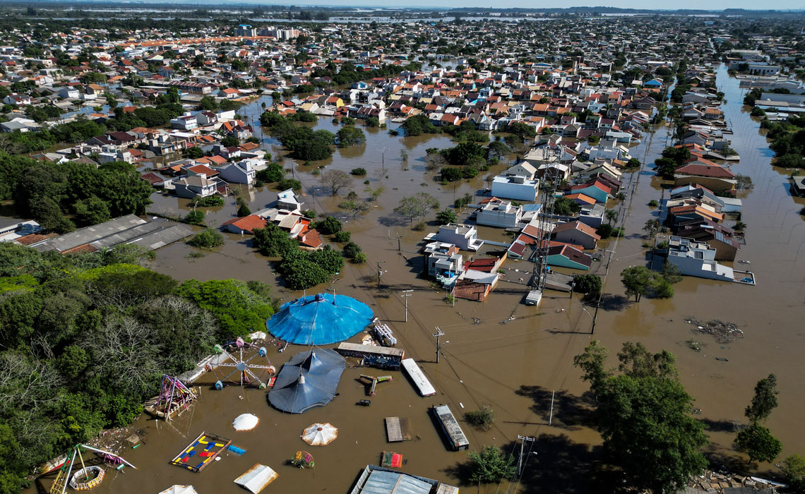
The volume of rain that fell in Rio Grande do Sul at the end of April and beginning of May was an extreme event that caused the biggest socioenvironmental disaster in Brazil’s history. On May 2, the Brazilian Center for Natural Disaster Monitoring (CEMADEN) issued a warning that some municipalities in Rio Grande do Sul had recorded almost 500 millimeters (mm) of rain over the previous 72 hours, including Santa Maria in the center of the state and Caxias do Sul in Serra Gaúcha. Other cities also received 200 to 300 mm of rainfall within three days.
These are enormous volumes of water. In the last 30 years, the average monthly rainfall for April and May across the state ranged from 100 to 220 mm, according to the National Institute of Meteorology (INMET). “Every weather forecast has limitations. But the disaster risk warning for Rio Grande do Sul was issued in advance back in April,” says CEMADEN climatologist José Marengo.
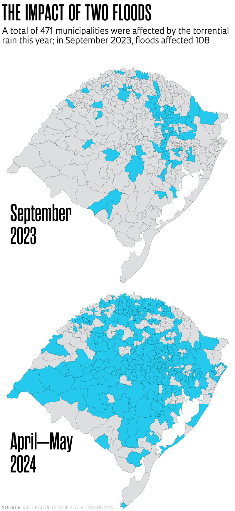
The heavy rainfall persisted into May and also began to impact the state of Santa Catarina. At the time of writing, 471 of the 497 municipalities in Rio Grande do Sul have been affected to some degree by the continuous rain and flooding, according to the state’s civil defense agency. It is like a tsunami has swept through the state. There have been 169 deaths and 44 people remain missing. In addition to the destruction of infrastructure and material goods causing billions of reais in losses, more than 2.3 million people were affected, with 580,000 residents forced to leave their homes and 47,000 living in temporary shelters. The full extent of the damage will only be known when the water has drained away from all of the flooded areas, which is a very slow process.
The devastating flood was caused in part by specific characteristics of the Rio Grande do Sul hydrographic network. Much of the rain that falls in the center and north of the state is carried by rivers to Lake Guaíba in the Metropolitan Region of Porto Alegre and then to the Lagoa dos Patos lagoon further south, which flows into the ocean. “In the Porto Alegre region, the water was slow to drain due to ongoing rainfall, waterlogged, saturated soil, and the winds blowing water away from the ocean,” explains Fernando Mainardi Fan, an environmental engineer from the Institute of Hydraulic Research (IPH) at the Federal University of Rio Grande do Sul (UFRGS). “During heavy rains last year, there were already some failures in the floodgate seals and pumps of the flood containment system at Lake Guaíba. This year, the system could not cope.”
Due to persistent flooding, several cities had to be partially or completely evacuated, such as Eldorado do Sul, Canoas, and Porto Alegre, which are all located near Lake Guaíba. The lake’s flood level is 3 meters (m), but the containment system is supposed to be capable of handling a water level of up to 6 m. This year’s flood raised the water level to a record 5.35 m. The previous record high was registered during the great flood of 1941, when it reached 4.77 m.
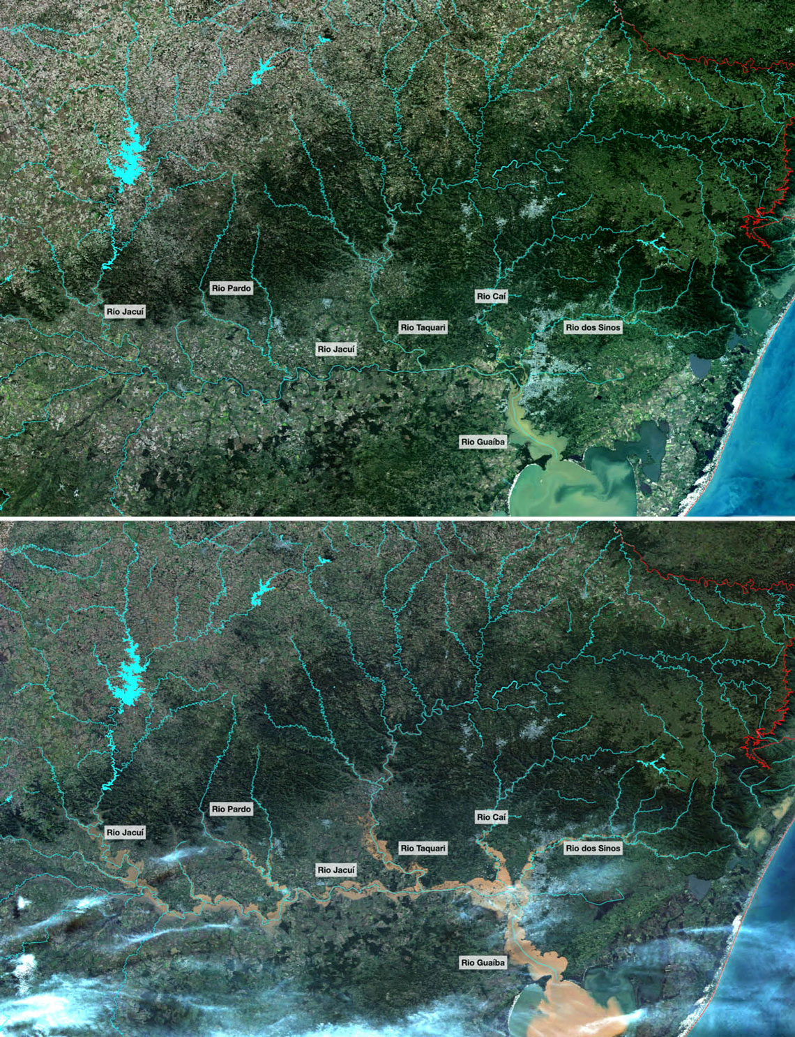
Inpe / Amazônia-1 / CBERS-4INPE images captured by the Amazonia-1 satellite on April 20, before the rainfall, and the CBERS-4 satellite on May 6, when the floods were at their worstInpe / Amazônia-1 / CBERS-4
According to Fan, the areas most affected were those surrounding the Jacuí, Taquari, Caí, Sinos, Gravataí, and Vacacaí rivers, in addition to Lake Guaíba (see comparative images). Towns near the Jacuí and Taquari rivers, such as Encantado and Muçum, were previously hit by floods at the end of 2023 and were now once again submerged. The increase in the water level was caused primarily by heavy rain and dams in the rivers close to Lake Guaíba.
Rio Grande do Sul is in a region that has received frequent warnings about potential disasters due to sudden climate variations. Since May 2023, the state has been mentioned in 12 of INMET’s monthly bulletins on extreme events, which describe meteorological phenomena such as rain and heatwaves that deviate from historical averages and have the potential to cause flooding, landslides, and other disasters. The most recent warnings for the state of Rio Grande do Sul were related to intense rainfall, including in September last year (see Pesquisa FAPESP issue nº 334).
Brazil’s climate has changed significantly over the last 30 years due to global warming, and according to experts, the south of the country is one of the regions most affected by heavy rain. Data from INMET for the 1991-2020 period indicate an average annual rainfall of between 1,400 and 2,200 mm in the south of Brazil. Between 1960 and 1990, the average ranged from 1,050 to 2,050 mm.
An increase in precipitation in the South and parts of the Southeast has also been observed in various studies. The trend differs from what is occurring in much of the rest of the country, which has been becoming drier over time (see Pesquisa FAPESP issue nº 338). “In other regions, it is possible to distinguish dry and rainy seasons. But in the South, we see precipitation that used to be well distributed throughout the year,” says Douglas Lindemann, a meteorologist from the Federal University of Pelotas (UFPel). “Fluctuations have always existed due to the influences of natural phenomena such as El Niño, which leads to more rain, and La Niña, which causes droughts. What has changed is that rain is no longer well distributed over time, instead falling very heavily in certain months.”
A study described in Nature Communications in September 2022 highlighted the intensification of river floods in the South. The article analyzed the extent to which the water cycle is changing across Brazil. As the planet gets warmer, this natural cycle — which comprises the processes of evaporation, plant transpiration, cloud formation, precipitation, and groundwater supply — undergoes changes. One explanation is that when the temperature is higher, the atmosphere retains more moisture (water vapor). This promotes meteorological conditions that lead to rainfall, such as extratropical cyclones.
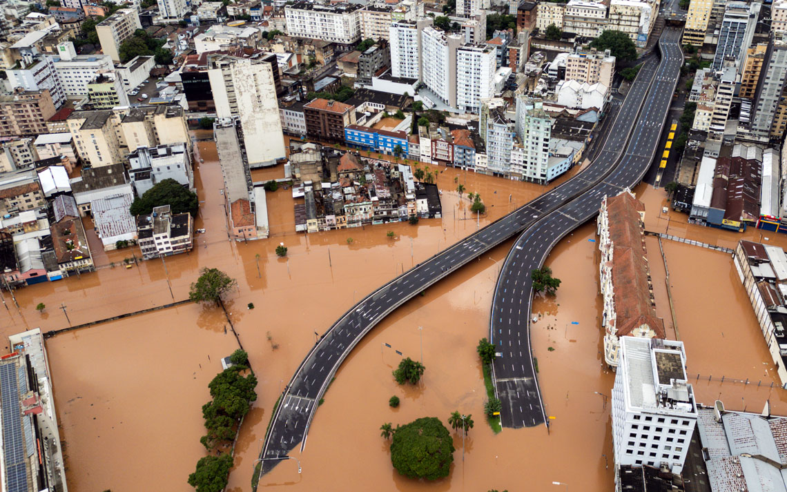
Carlos Macedo/Bloomberg via Getty ImagesThe city of Porto Alegre, completely flooded, on May 5Carlos Macedo/Bloomberg via Getty Images
The study analyzed data on daily river flow and runoff from 886 hydrometric stations between 1980 and 2015. The results indicate that in the south of Brazil, the north of the Amazon, and the easternmost region of Mato Grosso do Sul, floods have become more frequent and droughts less common. “The cycle has changed across almost the entire country. In the South, human activity is destabilizing the natural flow of rivers,” says Vinícius Chagas, lead author of the study and currently a postdoctoral researcher at the Federal University of Santa Catarina (UFSC), supervised by environmental engineer Pedro Chaffe.
In total, 69% of the southern region is experiencing more flooding, according to the article. The situation is critical in the northeast of Rio Grande do Sul (which was devastated by the recent tragedy), in almost the entire territory of Santa Catarina, and in the southeast of Paraná. In the south of Rio Grande do Sul, however, both floods and droughts have been less frequent or intense in the last 40 years. The data serves as a warning, despite the fact that not all floods or droughts have caused major disruptions. “The groundwater recharge period used to be year-long, but that has changed,” says Chagas.
It is difficult to list all the reasons for the changes observed in rainfall patterns in southern Brazil. The occurrence of rain depends on factors related to the atmosphere and the oceans — every extreme event is unique and the region’s climate is not homogeneous. During the recent disaster, specific weather conditions caused rain clouds to remain stationary over parts of Rio Grande do Sul for days on end, which led to concentrated precipitation in certain places. “The cold front, a result of the interaction between cold and hot air, is feeding back into Rio Grande do Sul because there is a lot of humidity and it is hot for this time of year,” explains Lindemann.
The scientific literature shows that climate systems become more unstable and unpredictable as temperatures rise. The year 2023, for example, was the hottest in the planet’s history. According to INMET, the average temperature in Brazil last year was 0.69 degrees Celsius (ºC) above the average over the last three decades, which was 24.23 ºC.
However, the torrential rainfall in Rio Grande do Sul this year occurred at a reasonably expected time that was forecast by several studies. During the El Niño climate phenomenon, which is characterized by unusually warm ocean temperatures in the Equatorial Pacific, the risk of extreme events throughout increases nationwide.
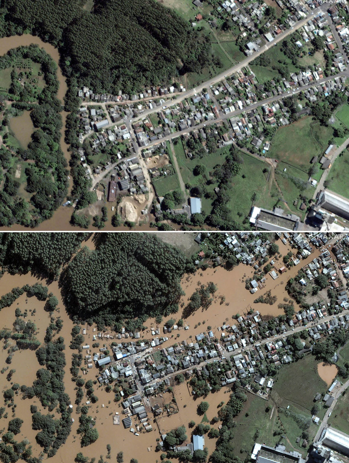
AFP Photo/Satellite Image ©2024 Maxar TechnologiesAerial view of the same region of Vale do Taquari after the floods of September 2023 (top) and May this yearAFP Photo/Satellite Image ©2024 Maxar Technologies
An article published in the International Journal of Climatology in August 2017 described the intensification of extreme rainfall in Santa Catarina due to El Niño events between 1979 and 2015, mostly in the spring. El Niño led to more extreme events than La Niña (abnormal cooling of the Equatorial Pacific) and neutral years, when ocean temperatures are within the expected range. Even so, the number of spring weather anomalies during La Niña and neutral years increased considerably between 2000 and 2015, while there was a small decrease in the number of significant events associated with El Niño.
“In Rio Grande do Sul, there was a severe three-year drought due to consecutive occurrences of La Niña. What we are seeing is that the time between these events is shortening, and La Niña is lasting several years at a time. This is likely a direct effect of climate change,” says oceanologist Regina Rodrigues of the Federal University of Santa Catarina (UFSC), coauthor of the article. The US National Oceanic and Atmospheric Administration (NOAA), which monitors the Equatorial Pacific region, announced in May that the current El Niño will end in June, and a La Niña will likely begin by September 2024.
The occurrence of extreme events linked to El Niño and La Niña has also been studied by UFRGS geographer Venisse Schossler. In an article published in the journal Revista Brasileira de Recursos Hídricos in 2018, she associated the abnormal warming and cooling of the Equatorial Pacific with variations in the Southern Annular Mode (SAM), a pressure belt around the Antarctic Circle that affects daily temperature and rainfall in the Southern Hemisphere. “When El Niño or La Niña is associated with the SAM, the scenario becomes favorable for more extreme events to occur. With climate change, the lowest layer of the atmosphere expands due to warming, and this affects the pressure fields,” explains Schossler.
