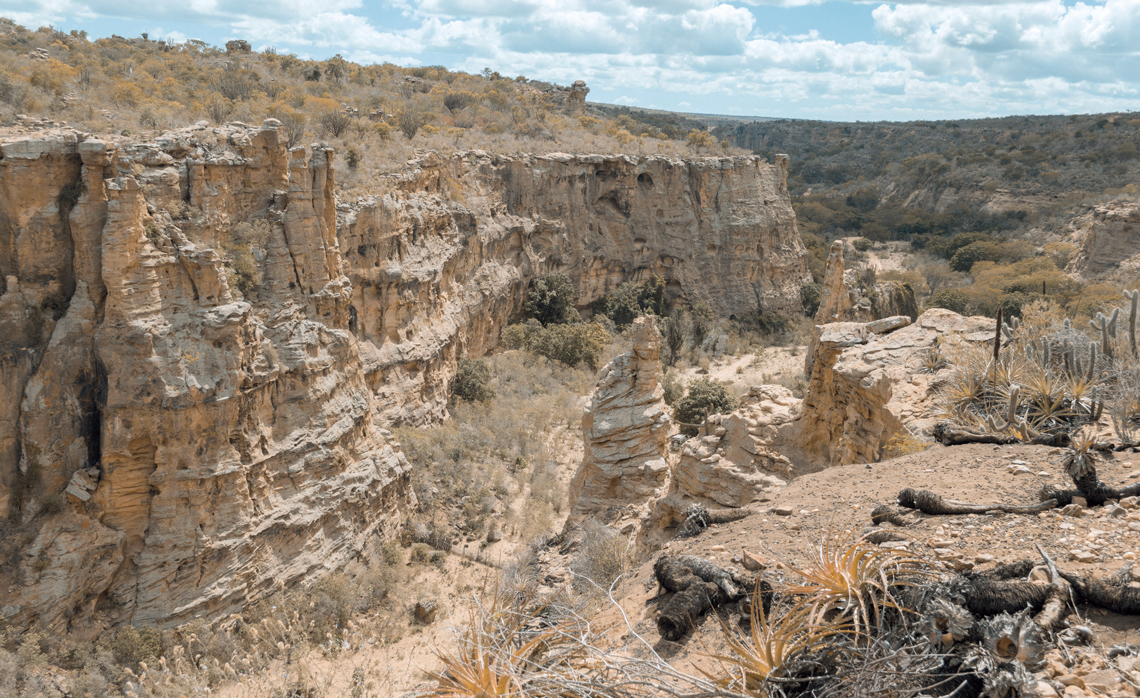
Last November, media reported that an area with a desert climate had been recorded in Brazil for the first time. The region is located in the lower-middle valley of the São Francisco River in the north of Bahia, on the border with the state of Pernambuco, and is almost four times larger than the city of São Paulo. It covers a small area on the border between the two states, near Petrolina on the Pernambuco side and Juazeiro in Bahia, as well as a larger strip of land between 200 and 300 kilometers further north.
The press reports of expanding dry areas were true in essence, but the tone was a little over the top. It is true that the area in question had been elevated from its historical status as semiarid to the current status of arid. Such a change is unprecedented in Brazil, and this area of the Northeast, measuring just over 5,700 square kilometers (km2), is now the driest in the country. But this does not mean that it is a desert, which is an ecosystem classified as having a hyper-arid climate — a more extreme status than arid — and almost no vegetation.
Media exaggeration aside, the key conclusion of the statement issued by the Brazilian National Institute for Space Research (INPE) and the Brazilian Center for Natural Disaster Monitoring (CEMADEN) supporting the reclassification of the northeastern area also confirmed the results of several studies with different methodologies carried out in recent years. Most of Brazil’s national territory, with the exception of the South and coastal regions of the Southeast, is becoming drier.
The dominant trend indicates that dry areas in the country (and worldwide) are becoming even drier and wet areas less wet. In Brazil, the clear exception to this trend are the three southern-most states, which are currently humid and are expected to remain so in the future. This evolution toward a drier climate is also occurring in some areas of the Amazon, the wettest biome in the country, where progressive deforestation and climate change are making the rainforest warmer and more prone to prolonged droughts.
“The atmospheric demand for water has significantly increased. This is making conditions in the Northeast and much of the country drier,” says INPE water resources engineer Javier Tomasella, one of the authors of the paper on advancing aridity. “Evapotranspiration is intensifying because Brazil’s temperature is rising due to global warming.”
The semiarid area has grown since 1960, now covering around 800,000 km2, 9.4% of the national territory
The increasing dryness, therefore, is not only — or even primarily — due to a lack of rainfall, but due to an increase in evaporation from the ground and plant transpiration, both of which are part of a process called evapotranspiration. “As long as there is water in the soil and the ability to photosynthesize is not an impediment, surface vegetation uses absorbed radiation energy to lose moisture instead of using it to heat the environment. This is a way of limiting the warming of the lower atmosphere, as a thermoregulation mechanism,” explains hydroclimatology expert Humberto Ribeiro da Rocha of the Institute of Astronomy, Geophysics and Atmospheric Sciences at the University of São Paulo (IAG-USP), who did not participate in the study. The hotter it is, the more the atmosphere demands water from the surface to obtain the fuel needed to form rain clouds: water vapor.
To classify the country’s climate, researchers from INPE and CEMADEN examined changes in the aridity index over the last six decades. They combined data from measurements taken at meteorological stations and estimates for four successive 30-year periods (1960–1990, 1970–2000, 1980–2010, and 1990–2020). The approach allowed them to see where moisture has moved over time. They then determined the moisture rate for the entire country, with a focus on the driest regions, for each 30-year cycle.
The aridity index of a region is calculated by a simple equation: the total accumulated rainfall divided by potential evapotranspiration (the maximum amount of water that can be lost to the atmosphere through the process). Some studies use rainfall values only, but the authors considered the aridity index more appropriate for the task at hand. Reports from the Intergovernmental Panel on Climate Change (IPCC) also use this index, in addition to analyzing changes in accumulated rainfall over time.
When the volume of rainfall exceeds the amount leaving the surface of a region through evapotranspiration, the resulting index score is greater than one. In the reverse situation (less rain than evapotranspiration), the aridity index value is less than one. Areas are considered dry when the ratio of rainfall to evapotranspiration is below 0.65 — meaning the volume of water that falls as rain is less than 65% of the volume that enters the atmosphere through plant transpiration and surface evaporation (see maps). Above this threshold, climates are considered humid.
Regions where the aridity index is below 0.05 are categorized as hyper-arid. “This is the climate of a desert,” says Tomasella. In Brazil, there are no such areas. Regions where the index is between 0.05 and 0.2 are arid, as is the case in the parts of Bahia and Pernambuco recently elevated to this status. A value of between 0.2 and 0.5 signifies a semi-arid zone, which applies to much of the interior of the Brazilian Northeast. Climates known as dry subhumid are represented by an aridity index of 0.50 to 0.65.
For example, in Chorrochó, a municipality in Bahia situated within the new arid zone, the total annual rainfall over the last three decades was 374 millimeters (mm). In the same period, the total evapotranspiration was 1,956 mm. The result is an aridity index of 0.19, within the range classified as arid. “Near the border between Bahia and Pernambuco, there are locations where the aridity index is very close to 0.2, sometimes slightly higher, with values of 0.21 or 0.22,” explains CEMADEN physicist Ana Paula Cunha, another of the study authors. “In the near future, these locations are likely to fall below 0.2, meaning they too will be classified as having an arid climate. If we take these places into account, the extent of the arid zone will increase from the current 5,700 km2 to almost 15,000 km2.”
The study by INPE and CEMADEN also looked at changes in total rainfall in Brazil. With this approach, the semiarid area is slightly smaller than when calculated by the aridity index, but it is still trending toward expansion. In Brazil, regions with less than 800 mm of annual rainfall are legally defined as part of the semiarid region.
The emergence of an arid area was only observed in the last 30 years of the analysis. The semiarid region, meanwhile, has been growing steadily over the last six decades. It increased from 570,000 km2 in 1960–1990 to almost 800,000 km2 between 1990 and 2020, equivalent to 9.4% of the national territory. This growth was due to the contraction of dry subhumid areas, especially between 1970 and 2010. However, in the 1990–2020 period, the areas classified as one of the three dry climates that exist in Brazil (arid, semiarid and dry subhumid) all grew.
The study also highlighted the emergence of two new dry subhumid zones in Brazil from 1990 onward: one in the middle of the Pantanal, the largest flooded plain on the planet, and the other in northern Rio de Janeiro State, in the Southeast of the country.
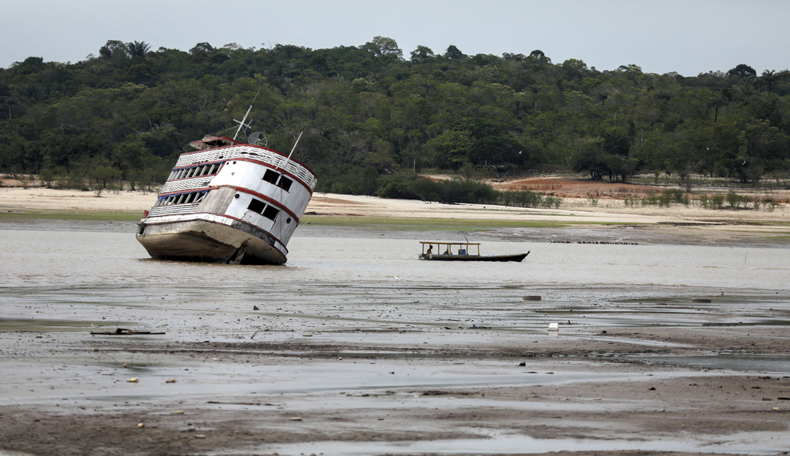
Michael Dantas / AFP via Getty ImagesA boat stranded in the Rio Negro in October 2023 due to a record-breaking droughtMichael Dantas / AFP via Getty Images
Several studies have indicated that other parts of the country, in addition to the Northeast, are becoming less humid. An article by ecologist Gabriel Hofmann of the Federal University of Rio Grande do Sul (UFRGS) indicates that the Cerrado (a wooded savanna biome), especially its central-northern region closest to the frontier of deforestation in the southern Amazon, has become significantly drier over the last three decades. Between June and November, a time frame that covers the dry season and the beginning of the rainy season, certain locations in the biome experienced an approximately 50% reduction in average accumulated rainfall and the number of days with rain. The article was published in the journal Scientific Reports in July 2023 (see Pesquisa FAPESP issue nº 333).
Other research indicates that there has been a reduction in the size of flood plains in the Pantanal, with the water pulse that sustains so much life in the region continuing to diminish. A paper published in the scientific journal Acta Limnologica Brasiliensia in 2020, before the biome was devastated by major wildfires during one of its worst droughts, reinforced this suggestion. The study identified that over a period of 10 years, the area in the north of the biome that flooded in August — the peak of the dry season — shrank by 16%. The research was led by Ernandes Sobreira Oliveira-Júnior, an aquatic ecologist from the State University of Mato Grosso (UNEMAT), Cáceres campus (see Pesquisa FAPESP issue nº 297). The situation makes perfect sense together with the emergence of a dry subhumid area in the west of Mato Grosso do Sul, as described in the statement issued by INPE and CEMADEN.
Humberto Barbosa, a meteorologist from the Federal University of Alagoas (UFAL), is not at all surprised by the increased aridity, especially in the Northeast. “For people living in the region, it is noticeable. When we go into the field, farmers and locals tell us that it used to rain more. Over the last 20 years, droughts caused not only by the declining rainfall, but also by increasing temperatures, have caused water loss to rise significantly,” says Barbosa.
As highlighted in the 2021 IPCC report, climate change — driven primarily by global warming — accelerates the water cycle. Water is transported from the earth’s surface (where it is found as a liquid or as a solid in the form of glaciers) toward the atmosphere (in the form of water vapor), and vice versa, at an ever-increasing rate and intensity. This causes both heavier rainfall and floods, like those recently witnessed in the South of Brazil, and more severe droughts.
“Just because an area is becoming drier over time does not mean that it cannot also be subject to heavy rainfall concentrated within a few hours or days,” points out CEMADEN climatologist José Marengo. Sometimes the total annual rainfall does not change significantly, but its distribution over the year does. This can make the dry season hotter and longer, delaying the start of the rainy season. In these cases, when the rain finally arrives, it can be violent, with heavy thunderstorms. “We are now seeing this occur in the most deforested areas of the Amazon, in the south and east of the biome,” says Marengo.
Dry subhumid climate zones have emerged in the west of the Pantanal and the north of Rio de Janeiro
Although it is not a perfect indicator, total annual rainfall is an important parameter that must not be ignored. Data from Brazil’s National Meteorology Institute (INMET) show that between 1991 and 2020, annual rainfall was lower in around two-thirds of the country than in the previous 30 years. The most significant drops were in the Northeast, and to a lesser extent, in the Central-West, the north of the Southeast, and certain areas of the Amazon (south, east, and some of the west).
“In the Northeast of Brazil, we have seen annual reductions of more than 100 mm, especially at the Cipó meteorological station in Bahia, where there was a decrease of 685.8 mm,” says INMET meteorologist Danielle Barros Ferreira. In Parnaíba, Piauí, annual rainfall decreased by 599.5 mm and in Aracaju, the state capital of Sergipe, it dropped by 505.9 mm. Outside the Northeast, the decline averaged around 50–100 mm per year.
The INMET data also show that in the South of Brazil, at the far south of São Paulo, Mato Grosso do Sul, and Minas Gerais, and in some areas in the northwest and southwest of the North region, annual rainfall increased slightly (by between 100 and 250 mm per year) in the 1991–2020 period. In some locations there were even significant increases in rainfall, such as in Codajás, central Amazonas, in Bambuí, central Minas Gerais, and in Chapecó, western Santa Catarina. In these municipalities, the increase was 741.9 mm, 590.2 mm, and 509.1 mm respectively.
The scale of the reduction or increase in total rainfall must be put into perspective based on the characteristics of each region’s current climate. In the Amazon, where more than 2,000 mm of rain falls per year in most areas, a 100 mm drop in precipitation over 12 months may be of little importance. In a location in the semiarid Northeast, it could result in a much more severe drought.
There is no absolute consensus on precipitation forecasts for Brazil, a nation of continental proportions, over the coming decades, but the general trends are widely accepted. The projections follow historical data showing the evolution of precipitation in different parts of the country. “The risk of drought is the country’s biggest climate problem and the one that impacts the most people,” says meteorologist Gilvan Sampaio, general coordinator of INPE’s Earth Sciences division. “The effect of climate change on temperature is more direct and simpler than on rainfall. In Brazil, for example, I don’t know of anywhere that the average temperature is not rising to some extent. Rainfall is a more complex phenomenon, influenced in different ways by global, regional, and local factors.”
One certainty when it comes to rainfall is the key role played by the Amazon rainforest, which covers more than half of the country. Providing large quantities of water vapor (via so-called flying rivers) to other regions of Brazil, such as the Central-West, Southeast, and South, the largest tropical forest on the planet acts as a kind of continental air conditioning system for the whole of South America. As more and more of the forest is cut down, it is progressively losing its ability to remove more carbon from the atmosphere, thus worsening global warming, and providing less water vapor for rain to form over the forest itself and other regions.
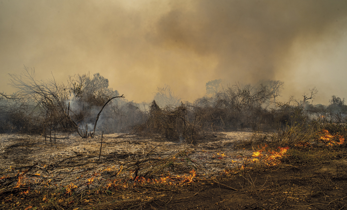
Lucas Ninno / Getty ImagesFires in the Pantanal in September 2020, during a major drought that devastated the regionLucas Ninno / Getty Images
Data shows that before the year 2000, the Amazon faced a major drought every 20 years. This century, there have already been four periods of extreme and prolonged drought, almost always associated with warming of the tropical Atlantic and the occurrence of the climate phenomenon El Niño, characterized by unusual warming of surface waters in the eastern Pacific Ocean. The first was in 2005, the second in 2010, the third in 2015–2016, and the most recent in 2023–2024. Last year, which was the hottest on record in Brazil and worldwide, some rivers in the North reached their lowest levels for more than 120 years.
An article published in Science in February projected that by 2050, half of the Amazon could reach a point of no return due to climate change and deforestation, which are causing unprecedented water stress in the region. If this were to occur, a considerable part of the forest would likely become degraded, home to fewer species, or even a savanna, with few trees and more grasses. Either way, the impact would be terrible for the local and regional climate, which would become much hotter and drier. The lead author of the paper was Bernardo Flores, an ecologist doing a postdoctoral fellowship at the Federal University of Santa Catarina (UFSC).
The process through which parts of the Amazon transform into something more closely resembling a savanna is known as savannization. A recent study indicated that the dual effects of complete savannization of the Amazon and an increase in the planet’s average temperature of four degrees Celsius (°C) by the end of this century — the most pessimistic outlook predicted by the IPCC — would be devastating. The scenario was simulated with the Brazilian Earth System Model (BESM), developed by INPE as part of the FAPESP Research Program on Global Climate Change (PFPMCG). The results were compared with projections for other less radical scenarios modeled with BESM.
“Each of these two factors alone would lead to a longer dry season and reduced rainfall across large regions of South America,” says climatologist Carlos Nobre of USP’s Institute of Advanced Studies, one of the authors of the paper, which was published in Scientific Reports in March. “Combined, they would lead to a 44% reduction in annual rainfall and a 69% increase in the length of the dry season in the Amazon.” In this radical but not impossible scenario, the transportation of water vapor from the Amazon to the rest of South America would be compromised, putting the supply for human populations at risk and jeopardizing activities that depend on water availability, such as agriculture and the generation of hydroelectric energy.
The areas currently most vulnerable to a decrease in humidity are those classified by INPE and CEMADEN as having climates with some degree of aridity, such as dry subhumid, semiarid, and arid climates. Even if these regions are not technically deserts, they become drier earlier and to a greater extent than the others.
Projects
1. INCT for Climate Change (nº 14/50848-9); Grant Mechanism Thematic Project; Program FAPESP Research Program on Global Climate Change (PFPMCG); Principal Investigator José Antônio Marengo Orsini (CEMADEN); Investment R$5,300,662.72.
2. Transition to sustainability and the water, energy, and food security nexus: Exploring an integrative approach with case studies in the Cerrado and Caatinga biomes (nº 17/22269-2); Grant Mechanism Thematic Project; Program FAPESP Research Program on Global Climate Change (PFPMCG); Principal Investigator Jean Pierre Ometto (INPE); Investment R$2,133,962.04.
Scientific articles
Bottino, M. J. et al. Amazon savannization and climate change are projected to increase dry season length and temperature extremes over Brazil. Scientific Reports. Mar. 1, 2024.
TOMASELLA, J. et al. Elaboração dos mapas de índice de aridez e precipitação total acumulada para o Brasil. Technical note from CEMADEN & INPE. Nov. 2023.
HOFFMAN, G. S. et al. Changes in atmospheric circulation and evapotranspiration are reducing rainfall in the Brazilian Cerrado. Scientific Reports. July 11, 2023.
LÁZARO, W. L. et al. Climate change reflected in one of the largest wetlands in the world: An overview of the northern Pantanal water regime. Acta Limnologica Brasiliensia. Sept. 18, 2020.
Republish