On October 18, the water meter that the Navy has used for the last 120 years to measure the height of the Paraguay River in the municipality of Ladário, Mato Grosso State, recorded a level of 33 centimeters (cm) below zero. It was the lowest level measured since September 1971, when it reached -51 cm, and is among the six lowest recordings ever taken by the meter, the oldest of six installed around the Paraguay basin, whose floods and droughts dictate the periodic flooding that makes the Pantanal the largest wetlands on the planet. The record low was measured in 1964, at -61 cm. On October 18, 2019, a year with little rain, the meter reached 1.76 m above zero, two meters higher than in 2020.
Between November 2019 and mid-March of this year, usually the region’s wettest period, only 350 mm of rain fell over the basin, just over 40% of the historical average, according to a survey by EMBRAPA Pantanal. “This year, the Pantanal has seen its lowest level of flooding in half a century,” says biologist José Sabino, a fish specialist at Anhanguera-Uniderp University in Campo Grande. Zero on the meter in Ladário indicates that the Paraguay River is just 4 meters deep. Such low levels point to a severe water shortage. Navigating the waterway by boat is impossible in such conditions, impacting the transportation of soy and ore produced in the country’s Midwest.
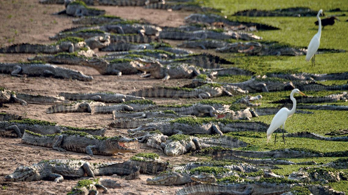
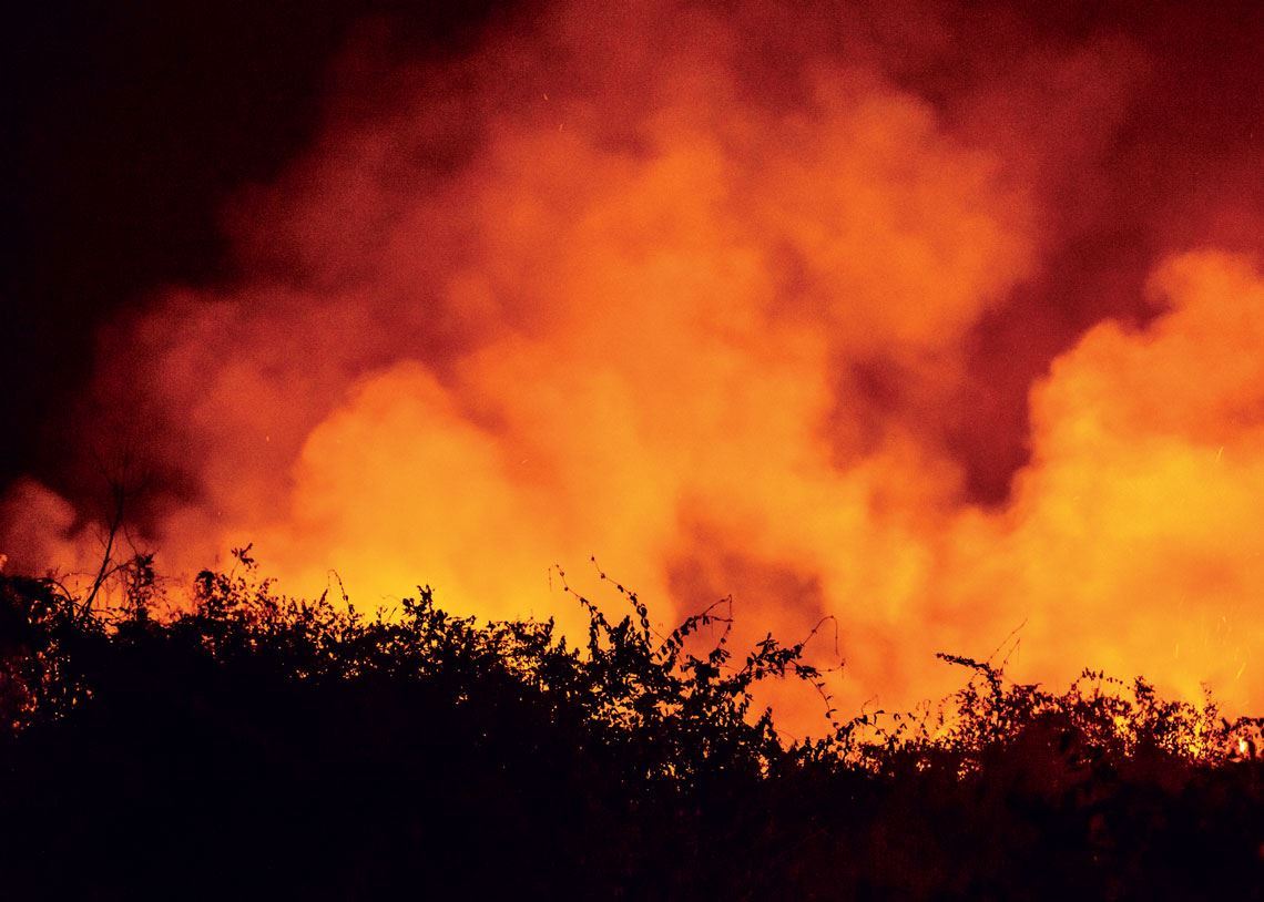
This extreme drought is the backdrop to an increasing number of fires that have ravaged the Pantanal this year, the smallest of Brazil’s six terrestrial biomes. The Pantanal stretches over 150,000 square kilometers (km2) in the states of Mato Grosso and Mato Grosso do Sul, an area equivalent to 1.8% of Brazil’s national territory. A small fraction of the biome, roughly 30,000 km2, is located in the neighboring countries of Paraguay and Bolivia. The intensity of the fires in 2020 is incomparable with recent years and has further stifled the biome’s natural flood pulse, devastating its flora and fauna. Images of flames engulfing the vegetation—a combination of forest, savannah, and fields occupy 84% of the Pantanal—and dramatic photographs of dead jaguars, alligators, and birds made national and international headlines.
Between January and October 18, 2020, 27% of the ecosystem’s area experienced fires, including in conservation units and indigenous reservations, according to data from the Environmental Satellite Applications Laboratory (LASA) at the Federal University of Rio de Janeiro (UFRJ). “The average area of the Brazilian Pantanal that suffers from fires in any given year is no more than 10%,” says climatologist Renata Libonati, a coordinator at LASA, who has been monitoring the advancing flames in the biome since last year. “The Pantanal developed by adapting to fire to a certain degree, and is capable of partially regenerating, but it cannot withstand the current levels.” Using an algorithm to automatically recognize areas of fire in images captured by the Visible Infrared Imaging Radiometer Suite (VIIRS) on American S-NPP satellite, researchers at LASA can identify fires in areas of at least 25 hectares, which is equal to 500-meter square.
Data from the fire monitoring program run by the Brazilian National Institute for Space Research (INPE) also highlights an unparalleled level of fire in the biome this year. As of October 25, 20,996 outbreaks had been registered in the Pantanal in 2020, more than double the total from 2019, which itself was the fourth worst year on record. The number of fires in the first 10 months of 2020 far exceeds the annual figure for any year since 1998, when monitoring in the Pantanal began. Before 2020, the worst year for fires in the region was 2005, with 12,536 outbreaks.
The severe and prolonged drought has created the perfect conditions for fires to burn for longer and to spread more easily, but drought alone is not able to spark the fires. “There are three ingredients needed for a forest fire to occur,” explains Libonati. “You need fuel, an oxidizer, and an ignition source.” The fuel is the natural vegetation, which in dry years is more exposed and more susceptible to advancing flames. The oxidizer, which reacts with the fuel and helps sustain the fire, is the weather conditions, such as prolonged drought, low humidity, high temperatures, and strong winds. Ignition, meanwhile, can occur in two ways: naturally, by means of lightning, or from a human source.
In contrast to the Amazon, a humid biome where natural fires are virtually nonexistent, lightning can start fires in the Pantanal, but only under very specific conditions. The ignition of vegetation without human intervention occurs only in the transition periods between the dry and wet seasons, which is when lightning occurs. But even then, fires caused by lightning are considered extremely rare. “The 2019 rainy season in the Pantanal was weak. Rainfall was also lower than normal in 2020. This long drought, in addition to the hot, dry air, favors the occurrence of larger fires,” explains climatologist José Marengo, head of the Research and Development sector at the Brazilian Center for Natural Disaster Monitoring (CEMADEN). In 2020, two-thirds of the nearly 21,000 fires occurred in August and September, at the height of the dry season, according to data from INPE.
This supports the idea that most fires in the Pantanal were caused by human activity. Using fire to clear vegetation and regenerate the soil for agriculture is an ancient practice still used in many places around the world. As well as providing benefits to crops, small and controlled fires can decrease the amount of biomass that could potentially cause larger fires. In the Pantanal, it is no different. While controversial, the procedure, when performed according to the law and technical criteria, does not lead to fires of the quantity and extent seen this year.
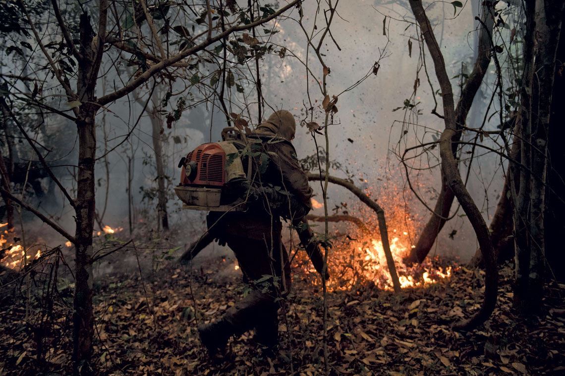
It is possible that in a very dry year like 2020, some deliberate fires that would usually be easily managed have spread out of control due to a combination of factors, such as inexperience of those using the method or excessive biomass (vegetation) on the ground. Another possible cause is deliberate fires started to clear new land for agriculture and cattle, the major economic activity in the Pantanal. “You cannot rule out arson as the cause of many fires,” says Sabino. “We can see that many fires start outside protected areas and then spread into and through them.” Although a July 15 federal decree banned fires on rural properties nationwide for 120 days and the state governments of Mato Grosso and Mato do Grosso do Sul both adopted similar measures, the Pantanal continued to burn.
Unlike the Amazon, where there are huge areas of public land, more than 90% of the Pantanal is privately owned. “We could identify who owns the land where the fires are occurring and hold them legally responsible,” says Libonati. The role of federal environmental agencies has been muted and uncoordinated when it comes to preventing and fighting fires. On October 21, the Brazilian Ministry of the Environment, for example, ordered the National System for Preventing and Fighting Forest Fires (PREVFOGO) to stop trying to contain the flames and return to their fire stations. A statement from the Brazilian Institute of the Environment and Renewable Natural Resources (IBAMA) claimed the move was taken due to a lack of resources. Two days later, on October 23, according to the Poder360 website, IBAMA received more funding and ordered the firefighters to resume their duties.
Mauro Pimentel / AFP
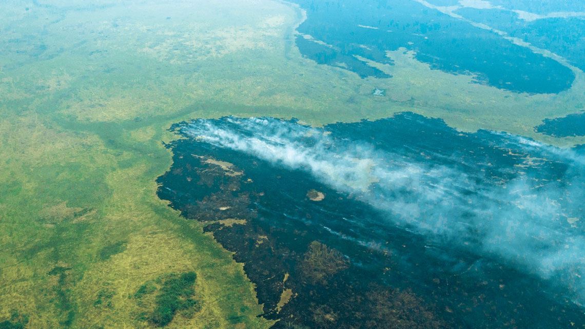
Aerial view of the smoke produced by fires in the Pantanal, taken on September 14
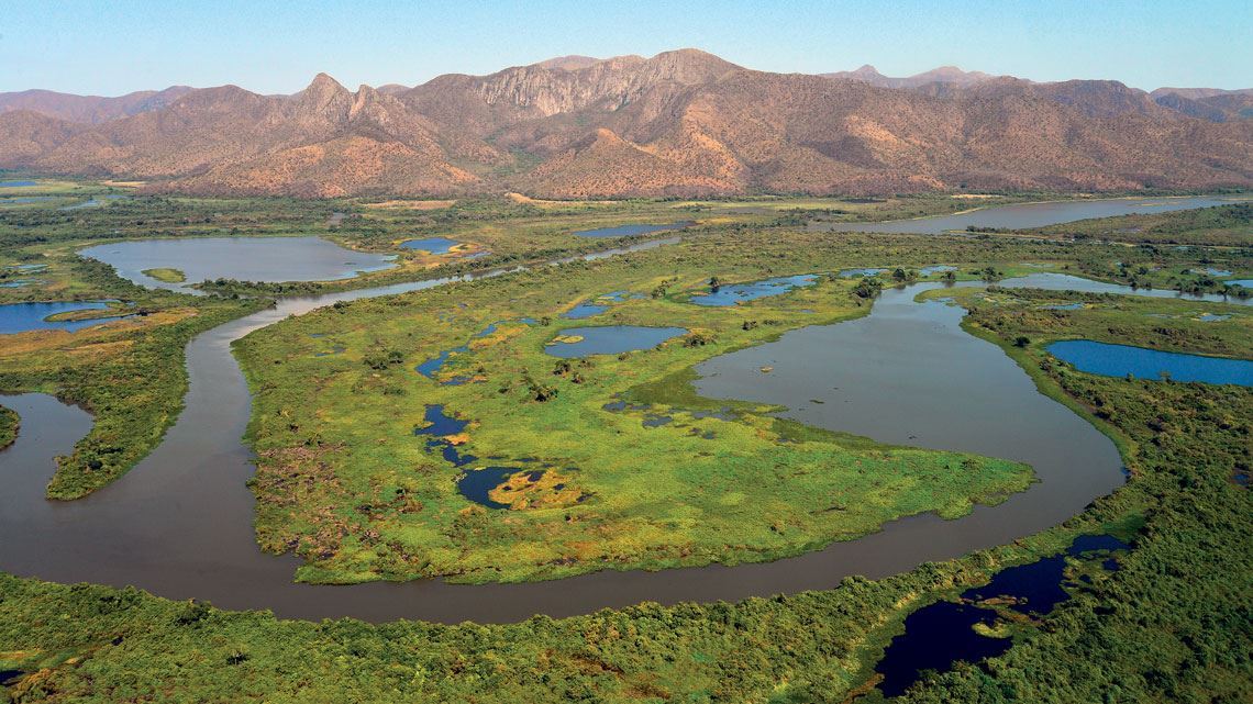
Mauro Pimentel / AFPThe dynamics that make the Pantanal such a unique biome result from its highly particular natural conditions. It is an extremely flat region, a plain with altitudes that rarely exceed 200 meters. In the north, however, it is slightly higher than in the south. On average, the altitude decreases by a few centimeters per kilometer you travel toward the south. This creates a gentle slope, meaning all the water that enters the Paraguay basin flows in a southerly direction. The Paraguay River and its tributaries follow the natural path of the rainwater flow. For the flood and drought cycle, it is important that it rains not only locally, but also at the river sources, located in the surrounding plateaus, before flowing to lower areas of the plain. “It can take up to six months for the waters in the very north of the basin to reach the south of the Pantanal,” says geologist Mario Assine, from the São Paulo State University (UNESP), Rio Claro campus, who has been studying the region’s geomorphology for 25 years.
The waters travel so slowly because the Paraguay River, which is 2,700 km long, passes through two major bottlenecks in Brazil: one in the north, when it reaches the Amolar mountains; and the other about 500 km to the south, in Urucum. The narrowing of the banks causes the river to overflow in several locations, creating the seasonally flooded landscape, punctuated by lakes and marshes. Assine and his colleagues examined satellite images from 2006 to monitor the flood and drought pattern of a typical year in the biome, the results of which were published in the book Dynamics of the Pantanal Wetland in South America in 2016.
José Sabino
A stretch of the Paraguay River that passes the Amolar mountains on the border between the states of Mato Grosso and Mato Grosso do Sul
José SabinoAccording to the study described in the book, only a small section in the northwest and central region of the biome around the Taquari River were flooded in January 2006. Between March and May, flooding in these areas intensified and even reached the central-eastern Pantanal, a region that is generally less susceptible to floods. At the height of the dry season in June and July, almost the entire west of the biome, from north to south, was under water—a result of the rain that fell in the north earlier in the year. From August to November, the west began to dry out, but sectors of the central region around the Taquari remained flooded, although less so than before. “This flood dynamic is essential to the maintenance of the Pantanal,” says Assine. “If it changes, the entire floodplain loses its fundamental characteristics.”
Studies carried out before this year’s drought and escalating fires indicate that the flood cycle may be losing strength. An article published in the scientific journal Acta Limnologica Brasiliensia in September this year calculated that the area flooded in the north of the Pantanal in August—the peak of the dry season—had reduced by 16% over a period of 10 years. In 2008, flood waters covered 1,125 km2 of land, according to satellite images. In 2018, only 950 km2 flooded. “This is due to a fall in the number of days on which it rains in this region,” says aquatic ecologist and lead author of the study Ernandes Sobreira Oliveira-Júnior, from the State University of Mato Grosso (UNEMAT) in Cáceres. Oliveira-Júnior and his colleagues analyzed historical monthly rainfall data from over 42 years, between 1971 and 2013. “Today, there are 13% more days without rain in the north of the Pantanal than 50 years ago,” says the UNEMAT researcher.

Predictions about the future climate in the Pantanal are uncertain. “Most climate models indicate an increase in temperature over the coming decades,” explains Marengo. “Although there is no consensus on future rainfall trends, most forecasts suggest the climate in this biome is going to be drier.” With the Amazon to its north, whose “flying rivers” provide moisture to the entire country (see Pesquisa FAPESP issue no. 158), rainfall patterns in the biome are partly influenced by the enormous rainforest. If less rain falls in the Amazon, the Pantanal will probably receive less water. Similarly, if it rains less at the headwaters of the rivers in the Paraguay basin, which are situated in areas close to the Cerrado (wooded savanna), the great floodplain shrinks.
An article published in the journal PLOS One in January this year, before the most significant fires began, suggests that in the near future, the Pantanal may suffer from more and more extreme events as a result of climate change. This includes both intense and prolonged periods of rain and drought. In the Pantanal, according to the study, there has been a trend toward repeated severe droughts. “These droughts are caused mainly by warming surface waters in the Atlantic and Pacific oceans in the Northern hemisphere,” German biologist and lead author of the paper Karl-Ludwig Schuchmann, from the Zoological Research Museum Alexander Koenig in Bonn and the Federal University of Mato Grosso (UFMT), told Pesquisa FAPESP “If the rainfall system collapses, the Pantanal as we know it will cease to exist.”
In the second half of October, as expected, the rains began to return to the Pantanal. But it is not yet known how much rain will fall. It should help to reduce the fires, but it could also cause a typical problem in post-fire seasons, when large amounts of ash and oxidized biomass are washed into rivers and lagoons, potentially suffocating fish and other water animals. This natural annual phenomenon, known locally as the decoada, reduces the amount of oxygen available in the water and increases the carbon dioxide. “It is possible that the decoada this year will be more intense than usual,” says Sabino, who studies fish in the Pantanal. “If the ashes of these record-breaking fires do not soak into the ground, an unprecedented decoada is likely to occur.”
Project
Paleo-hydrological changes, chronology of events and sedimentary dynamics in the quaternary Pantanal basin (No. 14/06889-2); Grant Mechanism Regular Research Grant; Principal Investigator Mario Luiz Assine (UNESP); Investment R$253,715.39.
Scientific articles
LÁZARO, W. L. et al. Climate change reflected in one of the largest wetlands in the world: An overview of the Northern Pantanal water regime. Acta Limnologica Brasiliensia. Sept. 18, 2020.
THIELEN, D. et al. Quo vadis Pantanal? Expected precipitation extremes and drought dynamics from changing sea surface temperature. Plos One. Jan. 7, 2020.
Republish