At the beginning of May, newspaper, website, and television reports portrayed the recovery of major cities in the state of Rio Grande do Sul that were hit by the colossal flood one year ago. However, little attention was given to the consequences of the landscape changes in rural areas and in less populated municipalities. Open fissures on the hillsides resulting from landslides, and shallower rivers due to the accumulation of soil and sediments carried by rainfall, have left Brazil’s southernmost state even more susceptible to erosion and flooding, even during lighter rainfall than occurred in 2024. The region is already naturally vulnerable to the climate, due to its geographical position, terrain, and shallow soil (see Pesquisa FAPESP issue n° 340). In the second half of June, heavy rains returned and around 170 cities reported flood damage, forcing more than 9,000 people to leave their homes and seek temporary shelter.
The major flood in April and May of last year affected 478 of the 497 municipalities in the state of Rio Grande do Sul, flooding 15,000 square kilometers (km2) and directly impacting 2.4 million people. The episode “highlighted existing vulnerabilities in urban planning, water resource management, and communicating risks to the population,” noted the book As enchentes de Rio Grande do Sul (the floods of Rio Grande do Sul), coordinated by Brazil’s National Water and Sanitation Agency (ANA), published at the end of April.
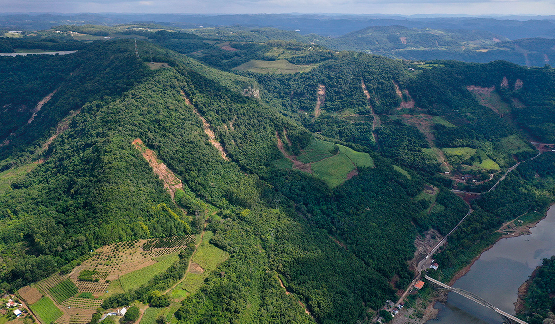
One year later, there are still reasons for concern. “The areas that suffered landslides remain vulnerable to rainfall and erosion until the vegetation cover returns,” explains geographer Harideva Egas, from the Brazilian Center for Natural Disaster Monitoring (CEMADEN). “More heavy rain could cause new landslides in the already impacted areas.”
He and fellow geographer Rodrigo Stabile coordinated a mapping exercise using high-resolution (3 meter) satellite imagery, which identified 15,087 landslides between April 30 and May 6, 2024. Triggered by the heavy rains, the landslides left marks on the terrain—landslide scars—concentrated in hillside areas of the central-northeastern portion of Rio Grande do Sul, along the basin of the Rio Guaíba, according to a study published in November in the scientific journal Landslides.
The landslides spread across an area of 63,000 km2, affecting 130 municipalities, leaving scars up to 2 km long, and directly contributing to the death of at least 67 people.
“The water that swept down the hills dragged soil and tree trunks, covered streams, and formed natural barriers that temporarily dammed the flow,” says Egas. “When the barriers broke, they released waves of mud and debris that caused violent flash floods, which in some places reached up to 4 m in height, leaving towns such as Roca Sales, in the Taquari Valley, 142 km from Porto Alegre, covered in mud.” He visited the region for the first time in September 2024 to verify, in the field, the conclusions about the landslides drawn from satellite imagery.
“Residents of rural areas were more concerned about flooding, since landslides were not common,” comments Stabile, who participated in the expedition. “They said nothing like that had ever happened before, but, as we saw, the properties sat on layers of sediment likely the result of past landslides over the course of thousands of years.”
Egas returned to the Bento Gonçalves region in March this year and observed that the vegetation had already began to cover some scars left by the landslides. Others, however, still display patches of red soil exposed by heavy rainfall amid the forested hills.
“The ground movement continues in Bento Gonçalves, Gramado, and Lageado, for example,” observes forestry engineer Masato Kobiyama, coordinator of the Natural Disasters Research Group of the Hydraulic Research Institute at the Federal University of Rio Grande do Sul (GPDEN-IPH-UFRGS). “There is still a lot of water in the soil, that has penetrated the fissures in the underground rocks and has not completely evaporated.”
Kobiyama has been visiting the region hit by the rains. He accompanied Egas and other researchers in March and, together with colleagues from UFRGS, produced a synthesis of the 2024 tragedy in an article published that same month in Revista Brasileira de Recursos Hídricos. “In my opinion, there are many more than 15,000 landslides, maybe twice as many, because the satellite doesn’t detect the smaller ones, between 1 and 2 m, which I regularly see on the hillsides,” he observes.
At least 35% of the volume of sediment displaced by the landslides reached the rivers, especially those near springs and canyons in the mountainous region, according to calculations by geographer João Paulo Araújo, who took part in the CEMADEN survey. Stabile estimates that this volume corresponds to at least 10 million tons (t) of sediment, enough to fill almost seven Maracanâ stadiums, the largest in Brazil, located in Rio de Janeiro.
Environmental engineer Hugo Fagundes, from the University of Campinas (UNICAMP), estimated—based on a mathematical model representing water flow in large-scale river basins—that the Rio Guaíba alone, which crosses the Metropolitan Region of Porto Alegre, would have received around 5 million tons of sediment between April 27 and June 17, 2024. “Part of this volume of sediment, which we are unable to quantify, remained in the rivers, while another part was carried by the rivers towards the sea.”
While lighter sediment is transported by the water, heavier particles settle on the riverbed, making the river shallower and reducing its capacity to allow the flow of rainwater. This phenomenon increases the size of river islands where sediment accumulates, complicates navigation, and creates the need for dredging to remove excess sediment.

Cleberton Bianchini / FREITAS, E. M. de et al. Marcas na paisagem. 2025 | Elisete Freitas / FREITAS, E. M. de et al. Marcas na paisagem. 2025 The banks of the Rio Forqueta, a tributary of the Taquari, in November 2022 (left) and in August 2024Cleberton Bianchini / FREITAS, E. M. de et al. Marcas na paisagem. 2025 | Elisete Freitas / FREITAS, E. M. de et al. Marcas na paisagem. 2025
“The rivers are clogged with silt, organic matter, furniture, and branches,” commented the mayor of Sapucaia do Sul (Rio Grande do Sul), Volmir Rodrigues, during a debate held in the Brazilian House of Representatives in Brasília in July 2024, “The municipalities do not have the financial resources to carry out dredging.”
In December 2024, the state government of Rio Grande do Sul announced investments amounting to R$691 million for dredging the state’s waterways, as part of the environmental recovery program for areas impacted by the floods. “Dredging has already removed millions of cubic meters of sediment from the waterway channels between the ports of Porto Alegre and Rio Grande,” reported the Press Office of the Department of Environment and Infrastructure (SEMA) of Rio Grande do Sul.
It is unknown, however, whether these and other measures, such as the construction of dikes, will be sufficient to withstand the heavy rains, which are expected to be five times more frequent in southern Brazil over the coming decades, according to an article published in February in Geophysical Research Letters. “If it is not done well,” warns Kobiyama, “dredging provides a localized solution, restricted to the area where it is carried out, and can create a channel along the riverbed that causes water to flow more quickly, increasing flooding in areas close to the river’s mouth.”
The book As enchentes no Rio Grande do Sul emphasizes the preservation of green areas to hinder the construction of homes in areas of risk and block the advance of floodwaters. “In locations without vegetation cover, erosive processes tend to worsen,” stresses Fagundes. However, in a reverse movement, the area of agricultural land grew 35% from 1985 to 2022, increasing the vulnerability to severe climatic events, according to an article published in April in the journal Environmental Research Letters.
“The banks and the vegetation along the river banks should not be occupied, because of the dangers they pose to people in the event of flash floods,” adds Kobiyama. On June 4 and 5, at the invitation of a town councilor, he gave lectures to farmers, teachers, students, and other residents of Rolante, a municipality 90 km from Porto Alegre next to a river that has caused violent floods. “We all need to learn to observe the movements of rivers and the soil during heavy rains, so we can prepare for another climate attack,” he commented.
In Rolante, Kobiyama proposed the formation of community hubs, made up of volunteers, to organize the warnings and move residents to shelters in secure locations already stocked with food supplies, in the event of heavy rains. “In one city here in Rio Grande do Sul,” he says, “people took shelter in a church at the foot of a hillside, but had to evacuate quickly when they realized that the church could be hit by a landslide.”
The story above was published with the title “Lands in Rio Grande do Sul even more fragile” in issue 353 of July/2025.
Scientific articles
COLLISCHONN, W. et al. The exceptional hydrological disaster of april-may 2,024 in southern Brazil. Revista Brasileira de Recursos Hídricos. Vol. 30, e1. Mar. 19, 2025.
EGAS, H. M. et al. Comprehensive inventory and initial assessment of landslides triggered by autumn 2,024 rainfall in Rio Grande do Sul, Brazil. Landslide. Vol. 22, pp. 579–89. Nov. 26, 2024.
PETRY, I. et al. Changes in flood magnitude and frequency projected for vulnerable regions and major wetlands of South America. Geophysical Research Letters. Vol. 52, no. 5. e2024GL112436. Mar. 16, 2025.
TRANCOSO, R. et al. Deadlier natural disasters—a warning from Brazil’s 2024 floods. Environmental Research Letters. Vol. 20, no. 4. 41,001. Apr. 2025.
Books
AGÊNCIA NACIONAL DE ÁGUAS E SANEAMENTO BÁSICO. As enchentes no Rio Grande do Sul: Lições, desafios e caminhos para um futuro resiliente. Brasília: ANA, 2025.
FREITAS, E. M. de et al. Marcas na paisagem: Memórias para construir a resiliência no vale do Taquari (RS). Lajeado, RS. Editora Univates, 2025.
Republish