
National Library of France
The 1748 Carte de l’Amérique Meridionale was the first configuration of Brazil that resembles its layout today.National Library of FranceTo the Illuminati of the 18th century, maps were perfect mirrors of a territory, graphic projections onto the real world, even if neither the region itself that was portrayed nor its borders were fully known. The Portuguese ambassador in Paris, Dom Luís da Cunha, and the leading European geographer of that period, Frenchman Jean-Baptiste Bourguignon D’Anville, shared this opinion. In 1724, the two began a partnership that led to D’Anville drawing the Carte de l’Amérique Meridionale (Map of South America), printed in 1748. It was the first map of South America (or América Meridional) that gave Brazil features similar to those it has today. “The map these two conceived—by melding politics, diplomacy, geography, and cartography—‘invented’ a continental Brazil by tracing its boundaries in the way preferred by the Portuguese for their possession in South America,” says historian Júnia Ferreira Furtado from the Federal University of Minas Gerais, author of the book O mapa que inventou o Brasil (The Map that Invented Brazil) published by Odebrecht/Versal Editores, 2013. In 2014, it won first place in the Human Sciences category of the Jabuti Prize.
The configuration of Brazil’s territory had been established even before its discovery. In 1494, Portugal and Spain had signed the Treaty of Tordesillas in which it was agreed that all lands to be discovered that were situated up to 370 leagues east of the island of Cape Verde, in the Atlantic Ocean, would belong to the Portuguese. Lands lying to the west of that imaginary line would belong to the Spanish.
Brazil was discovered in 1500, and during the following century, with the increase in colonization and exploration of the territory, the situation began to change. The borders agreed to in Tordesillas were pushed westward because of the discovery of gold and precious stones in the more central region of Brazil.
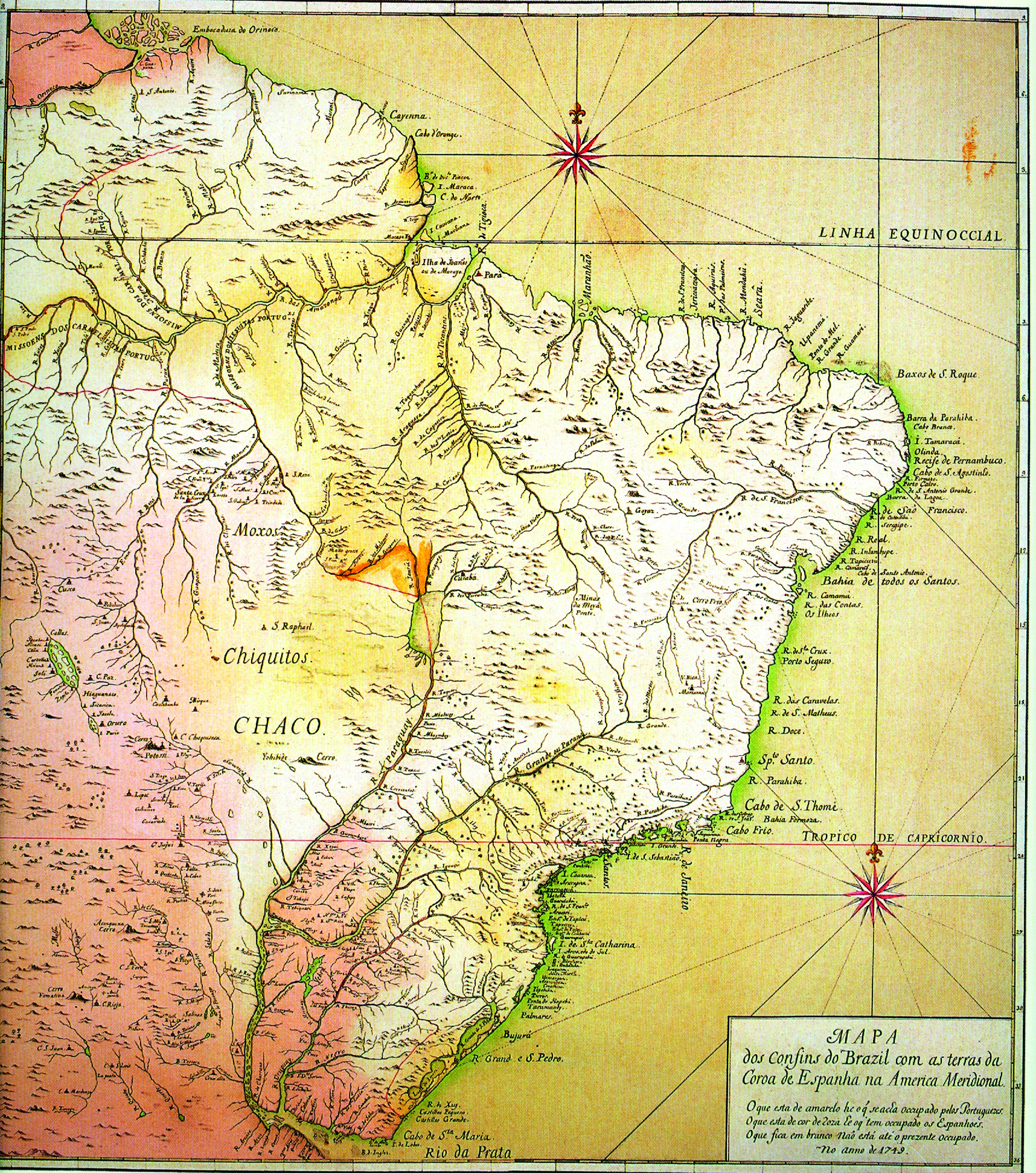
Fundação Biblioteca Nacional
The 1749 Mapa das cortes (above) was the basis for discussion of the Treaty of Madrid, in 1750, between Portugal and Spain.Fundação Biblioteca NacionalDom Luís da Cunha (1662-1749) knew how important the maps would be in diplomatic negotiations with the Spanish in the effort to shift the borders in South America in favor of Portugal. He also knew how meticulously D’Anville (1697-1782) drew his maps. Dom Luís was an experienced ambassador, respected in European capitals. He had as pupils Marco António de Azevedo, who became Minister of Foreign Affairs, and Sebastião José de Carvalho, the Marquis of Pombal. The Frenchman was a draftsman with a talent and taste for maps, who at age 22 had been appointed engineer and geographer to the king of France.
D’Anville was an erudite in-house geographer, who had never traveled outside of Paris. He created his maps by compiling and studying dozens of documents—other maps, reports by explorers and travelers, and data from astronomers, mathematicians, and cosmographers. He used that information to construct maps that were very close to reality. So it was that with the valuable aid of confidential information passed to him by Dom Luís, along with the knowledge that the Portuguese diplomat had about Brazilian territory, the Carte de l’Amérique Meridionale was produced.
Once the map was ready, in 1748, Dom Luís dispatched it to Lisbon. Alexandre de Gusmão, a diplomat who was the private secretary to Dom João V, gave orders that it not be shown to the Spanish and advised that he was having another map made in Portugal, to his order. That new map, the Mapa dos confins do Brasil com as terras da coroa da Espanha na América Meridional (Map of the boundaries of Brazil with the lands of the Spanish Crown in South America), which became known as the Mapa das cortes (The Courts’ Map), was the one used in the 1750 Treaty of Madrid that re-shaped the South American borders.
“The Mapa das cortes was compiled from several maps, including D’Anville’s, from which it copied the part about the Northern region of Brazil,” says Júnia Furtado. “It was custom-made to win more land in the negotiations with the Spanish and intentionally made some errors by situating territories colonized by the Portuguese further east than they actually were.” The researcher says, however, that no map from that period was as close to reality as the work by D’Anville, depicting a Brazilian territory that, strictly speaking, did not officially exist.
Republish