
It was previously thought that most of the Amazon rainforest was uninhabited or sparsely populated between the mid-thirteenth century and the beginning of the sixteenth century, but the recent discovery of 81 pre-Columbian archaeological sites in an area of southern Amazonia reinforces a hypothesis that has been defended by many archaeologists in the last 15 years: that the great rainforest, which stretches across much of Brazil and eight other countries, was home to complex societies and a large population before the arrival of the Europeans. The figures vary enormously, but the most widely accepted current estimates suggest that somewhere between 8 and 10 million people lived in the region—a contingent similar to that of the Incas, who occupied a much smaller area of the Andes in the precolonial era—rather than the maximum of 2 million proposed by American Betty Meggers (1921–2012), a pioneer of Amazonian archaeology who believed the region was a populational void.
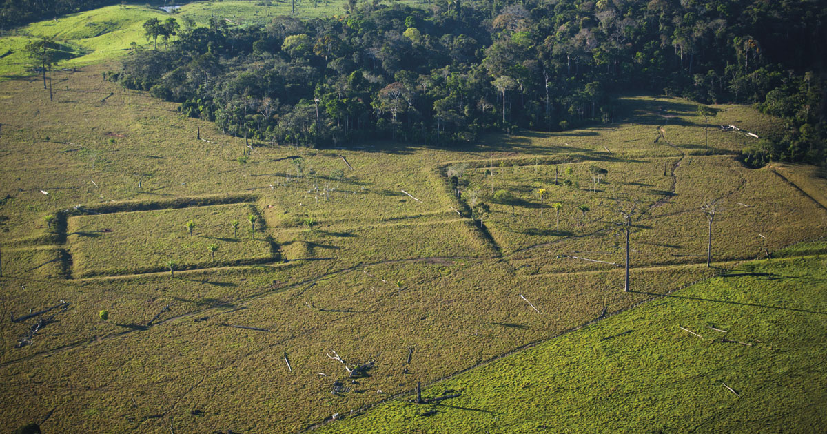
The new sites are located in an area of terra firme (“solid ground”) in the Tapajós river basin in Mato Grosso State. The area is relatively flat, does not flood, and is punctuated by gentle hills with elevations of 100 to 300 meters (m). At least 70% of the Amazon—roughly 5.5 million square kilometers (km2)—is classified as terra firme, also known as interfluvial areas. These locations are not usually the target of archaeological searches, for one simple reason: they lie outside river floodplains, which are the most fertile and richest natural areas. In theory, most precolonial populations should have been concentrated on the floodplains because the terra firme would have lacked the resources needed for their survival. “Interfluvial areas have always been overlooked, but our study shows that they may have been home to large human populations,” says Brazilian archaeologist Jonas Gregório de Souza, who is a postdoctoral research fellow at the University of Exeter, UK, and lead author of the Tapajós study, published in the scientific journal Nature Communications in March.
Souza worked with British colleagues from Exeter and Brazilians from the Federal University of Pará (UFPA), Mato Grosso State University (UNEMAT), and the Brazilian National Institute for Space Research (INPE). With the aid of satellite imagery and field work, the team identified 104 earthwork constructions and geometric designs in the Tapajós basin. They are composed of ditches and channels, generally circular, with diameters ranging from 11 m to 363 m, within some of which the scientists found the remains of old houses. In the area situated between the Aripuanã, Juruena, and Teles Pires rivers, they also found ceramic artifacts, traces of roads linking the villages, and what is known as Amazonian dark earth, a soil type formed of the organic debris that accumulates at locations of prolonged human occupation.

Mariana Cabral
Pre-Columbian monuments made of stone, found near the Brazilian coast in AmapáMariana CabralHuman occupation belt
This is not the first time that this type of prehistoric site, marked by geoglyphs and extensive earthworks, has been discovered in the Amazon over the last two decades. These geometric shapes have been found in dozens of places around the rainforest, from the Bolivian border, where the structures are sometimes square or hexagonal in shape, to the Upper Xingu region in the north of Mato Grosso State. Pre-Columbian sites surrounded by ditches or palisades have also been identified at the confluence of the Negro and Solimões rivers, about 30 km from Manaus, Amazonas, as well as in the state of Amapá and French Guiana. But the new discovery is different because of the location of the villages. “We focused our research on the Tapajós precisely because the area lies between the geoglyphs found in Acre and the Xingu sites. We wanted to know if any similar sites existed in this region,” explains Souza. “The Tapajós sites are not identical to those in Acre or Xingu. They seem to belong to another cultural tradition, but they are certainly related to these other two areas.”
The authors of the study say that if viewed together with the sites in Bolivia, Acre, and Xingu, the vestiges of human occupation in the Tapajós are part of a 1,800 km belt that spanned southern Amazonia in the precolonial period. Although there are regional distinctions, the inhabitants of this southern belt were linked by one particular trait: these pre-Columbian peoples, who lived in fortified villages, all left marks of their presence in the earth. “Ten years ago, we predicted that there may also be geoglyphs in the Tapajós basin, and this has now been confirmed,” says paleontologist Alceu Ranzi, a former professor at the Federal University of Acre (UFAC) and the Federal University of Santa Catarina (UFSC). Ranzi was coauthor of the new study and one of the first to identify these great geometric designs in Acre more than two decades ago. According to calculations and population projections made by Souza and his colleagues, somewhere between 500,000 and 1,000,000 indigenous people lived in up to 1,500 villages in the belt from 1250 to 1500. The area is equivalent to 400,000 km2—just 7% of the entire Amazon basin.

José Iriarte
Excavated ditch at an archaeological site in the Tapajós basinJosé Iriarte“Garden city”
Some of the most spectacular examples of this occupation on the southern fringes of the rainforest can be found at archaeological sites located in the regions inhabited by the Kuikuro people, who live in the Xingu Indigenous Park in the north of Mato Grosso State, east of the new discoveries in Tapajós. Working alongside Brazilian colleagues and two members of the Kuikuro, American anthropologist Michael Heckenberger, from the University of Florida, published an article in the journal Science in 2003 describing a group of 19 circular villages, the largest protected by palisades and ditches up to 5 m deep, interconnected by a network of dirt roads. The researchers estimated that between 2,500 and 5,000 people may have lived in the larger villages.
Heckenberger, who has studied the Xingu for three decades and spent numerous periods living in the region, calls this type of occupation a “garden city,” a kind of Amazonian architecture that flourished in the precolonial era. “It was a ‘galactic’ form of prehistoric urbanism, with no central authority, composed of clusters of small independent political entities within an egalitarian system of regional power,” explains Heckenberger. One trait of this type of occupation was the deep integration between the inhabitants and the natural resources provided by the rainforest, which was not left intact as something sacred, but managed in a way that would ensure the survival of the people.
As well as the evidence left in the Amazonian soil, the presence of large populations over a long period of time left other traces in the rainforest, so subtle that until recently they were ignored or interpreted as natural elements. Recent studies by biologists, ecologists, geologists, and botanists, often in partnership with archaeologists, have suggested that vast areas of the rainforest are not as pristine and untouched as previously thought, having been managed by indigenous peoples for generations. An article published in Science in March 2017 suggested that there is a greater number and diversity of trees typically used as food sources near old human settlements. The paper, whose lead author was biologist Carolina Levis, a PhD student at the Brazilian National Institute of Amazonian Research (INPA) and the University of Wageningen in the Netherlands, listed 85 plant species that were used and domesticated by indigenous peoples, including the açaí and rubber trees.

Brazil-nut trees near archaeological sites
In a 2015 paper published in the scientific journal Proceedings of the Royal Society B, a group of researchers from Brazil and the United States showed that Brazil-nut trees seem to be concentrated in the areas of rich, black earth that surround many archaeological sites. The phenomenon is most evident around old human settlements near the Amazon and Madeira rivers, and to a lesser extent, in the Tapajós region (see map). “Pre-Columbian peoples domesticated rice in the Amazon 4,000 years ago and shaped parts of the rainforest by planting rubber trees, Brazil-nut trees, and other crops,” says archaeologist Eduardo Góes Neves, from the Museum of Archaeology and Ethnology at the University of São Paulo (MAE-USP), an expert in Amazonian history and coauthor of the study. For Neves, the new sites discovered in Tapajós were not a surprise. “Anywhere we dig in the Amazon, we find something. Many areas we have not yet studied may have been home to complex cultures,” he suggests.
One area where archaeological research has developed over the last 10 years is the northern coast of the Brazilian state of Amapá, near the border with French Guiana. Scientists first became interested in the area after the discovery of the Rego Grande site near the town of Calçoene, 460 km north of the state capital, Macapá. Known colloquially as the Amazon Stonehenge (after the famous stone circle created in southern England 4,500 years ago), the site features a small group of granite megaliths erected by humans. Carbon dating by archaeologists Mariana Petry Cabral and João Darcy de Moura Saldanha, at the time working for the Amapá State Institute for Scientific and Technological Research (IEPA), indicated that the site, which was probably used for ceremonial purposes and possibly funerals, was occupied between 700 and 1,000 years ago, before European colonization.

Léo Ramos Chaves
Trees like the Brazil-nut tree were domesticated by pre-Columbian peoplesLéo Ramos ChavesDespite having moved away from Amapá, the pair are continuing their studies in the region, where there are an estimated 500 prehistoric sites. “We discovered old human settlements protected by ditches near the town of Oiapoque,” says Saldanha, who defended his PhD on this region at MAE-USP last year. “This was another region with a strong earthworks culture.” On the other side of the border, in French Guiana, the sites protected by ditches, which are usually situated at higher elevations, are known by local archaeologists as “crowned mountains.” Saldanha and Cabral also identified another type of monument associated with ceremonies and funerals: circles made of large logs marking and delimiting human burial grounds, some of which contain anthropomorphic urns. Nobody knows whether the people who inhabited the Amapá coast shared cultural traditions with the groups that made the geoglyphs in Bolivia and Acre and the geometric constructions in the Xingu and Tapajós regions. There is, however, one element that could link them, despite the geographical distance. In the pre-Columbian era, most of the tribes that lived in the coastal areas near French Guiana spoke languages from the Arawakan family.
Linguistic fragmentation
Many of the archaeological sites that feature extensive earthworks, such as the geoglyphs in Acre and the ancient villages in Xingu, are located in areas that were occupied by speakers of the Arawakan and Tupi-Guarani language families. According to linguist Patience Epps, from the University of Texas at Austin, the areas in Amazonia where these two families predominate are not generally contiguous with one another. “For a long time, this pattern was interpreted as an indicator that the indigenous groups were relatively isolated from each other, formed of small populations that rarely interacted,” Epps comments. “But I believe this linguistic fragmentation could actually be a result of the interaction between these groups, which would be consistent with the view that there were dense populations and complex social structures in these areas.”

Science / AAAS
Satellite image shows vestiges of pre-Columbian villages in Xingu, in the north of Mato Grosso State, marked by the letter X and a number. The red lines show the locations of old roads, and the black lines show the ditchesScience / AAASEpps studies how the speakers of different Amazonian languages interact and relate to each other. Many are closely linked by loanwords and grammatical similarities. She has spent years collecting data on the lexicon and grammar of hundreds of languages in the region, and found that the Arawakan and Tupi-Guarani language families gave the most words and expressions to other languages. Some terms or expressions, such as those for the heron or the number four, are used throughout the Amazon basin and shared by several languages. “There is evidence of this kind of interaction in some multilingual zones, such as the Upper Rio Negro and Xingu regions,” explains the scholar. “In these areas, the differences between languages are part of how different groups mark their place and their social role within a larger interactive system, like cogs in a machine.”
While the archaeological, botanical, and even linguistic evidence of a large precolonial population in certain areas of Amazonia is growing, there is still a question over the demographics of the region. Although there are fewer and fewer archeologists who still agree with Betty Meggers that the region was almost deserted before the Europeans arrived, there is also no evidence behind some of the more exaggerated population estimates that pre-Columbian Amazonia could have been home to 50 million people. “I do not believe that the current research allows us to extrapolate to the whole of Amazonia. That would be like generalizing the history of an entire continent,” says archaeologist Carla Jaimes Betancourt, from the University of Bonn, Germany, who studies sites in her native country of Bolivia. “We have evidence of large populations and greater population densities in some regions, such as Xingu and Moxos [Bolivia],” says Betancourt. “But we also have to admit that some research, such as that by [Dolores] Piperno [from the Smithsonian Tropical Research Institute], proves that there were equally deserted areas.”
Project
The archeology of the Middle Holocene and early landscape domestication in southwestern Amazonia (no. 17/11817-9); Grant Mechanism Regular Research Grant; Principal Investigator Eduardo Góes Neves (USP); Investment R$161,053.20.
Scientific articles
SOUZA, J. G. et al. Pre-Columbian earth-builders settled along the entire southern rim of the Amazon. Nature Communications. Mar. 27, 2018.
CLEMENT, C. R. et al. The domestication of Amazonia before European conquest. Proceedings of the Royal Society B. July 22, 2015.