Petrobras and the Senai Institute of Innovation (ISI) are working in partnership to produce a new technology in Brazil capable of reducing the installation costs of offshore wind farms at sea. The team of Brazilian scientists has created a device called Bravo—which in Portuguese stands for remote ocean wind assessment buoy—equipped with a system that automatically captures meteorological and oceanographic data, including the speed and direction of ocean winds. These data are essential to carrying out the energy potential studies needed before offshore wind farms can be built.
It is important for Brazil to develop technologies linked to harnessing the energy generated by the wind at sea because Brazil has a vast coastline and a large maritime area. Recent studies have revealed that many coastal regions represent suitable locations for wind farms, with wind speeds high enough to generate electricity.
“Several multinationals in the energy sector have shown interest in exploring our offshore wind potential. The Bravo project will give Brazil domestic access to a technology used to map offshore wind resources. There are currently no Brazilian suppliers offering their own verified equipment for this purpose,” says mechanical engineer Antonio Medeiros, head of research and development at ISI’s Renewable Energies division in the northeastern city of Natal. The ISI’s Embedded Systems division, located in Florianópolis, also participated in the project.
Some Brazilian companies, the specialist notes, already offer buoys that measure meteorological (air temperature, relative humidity, and atmospheric pressure) and oceanographic (waves and sea currents) parameters. “Most of these devices also measure surface winds—those at heights of up to 2 meters [m]. For wind farms further out at sea, however, we need to know the behavior of winds above 100 m, at the height of a wind turbine rotor,” says Medeiros. He points out that buoys like the Bravo are an alternative to fixed towers, which cost more to install.
Alexandre Nicolaos Simos, a naval engineer from the Department of Naval and Ocean Engineering at the Polytechnic School of the University of São Paulo (Poli-USP), praises Bravo’s development. “We are severely lacking in ocean-monitoring systems here in Brazil. Taking wind measurements in the maritime environment is essential to properly planning offshore wind farm projects,” he stresses. Simos is leading a study funded by FAPESP and other institutions that aims to develop floating wind turbines—most offshore turbines are fixed to the seabed by foundation pillars (see Pesquisa FAPESP issue nº 290).
Testing
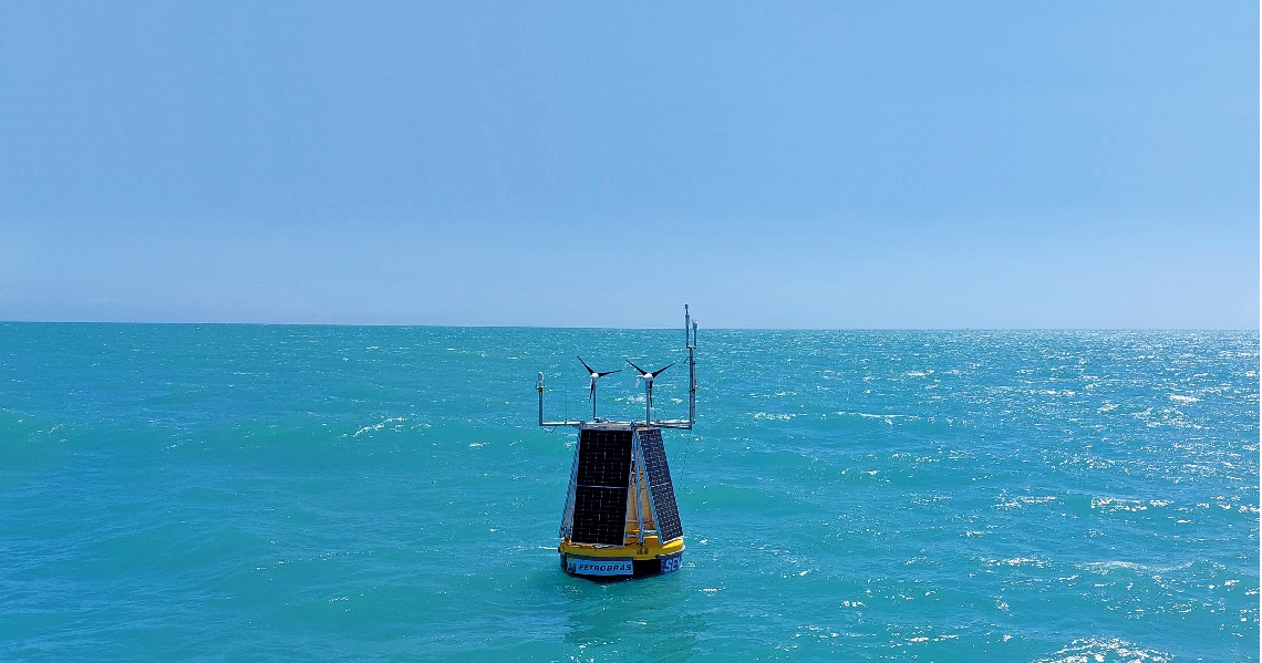
Tests on the first Bravo model began at the end of November. The buoy was launched about 15 kilometers (km) off the coast of Areia Branca, a municipality on the coast of the Brazilian state of Rio Grande do Norte, where it will remain for at least seven months. Measuring 2.5 m in diameter and 3.5 m high, it has a fiberglass hull, a metal structure to connect to the anchoring system, and a platform for the sensors, including an ultrasonic anemometer to measure wind direction and speed at sea level and a remote lidar (light detection and ranging) anemometer to measure wind parameters up to about 200 m above sea level.
The lidar sensor works by sending pulses of laser light upward, which are reflected back from various heights by particles or aerosols carried in the wind. The height at which the light is reflected is calculated based on how long it takes to bounce back. A physical phenomenon called the Doppler effect causes the frequency of the reflected light to be slightly different from when it was emitted by the lidar device. This difference is used to determine the speed at which the particle is traveling, and to consequently calculate the wind speed at the measured height.
The data is then transmitted to a cloud server via satellite for later analysis, explained the Petrobras press office. Photovoltaic panels and two small wind turbines provide the buoy with its own energy source.
The data collected by Bravo during the testing period will be compared with information collected by a fixed lidar sensor at Terminal Salineiro de Areia Branca port, located 26 km along the coast, near where the buoy was launched.
According to Petrobras, similar floating lidar sensors are already in use in countries such as the USA, France, the UK, and Norway. The company estimates that Bravo will provide savings of up to 40% on offshore wind measurement costs compared to hiring a foreign company to provide the service in Brazil. “Bravo will help increase the supply of services and reduce the cost of implementing offshore wind projects in the country,” said Petrobras.
Marcelo Dottori, a physicist with a PhD in oceanography who heads the Coastal Hydrodynamics Laboratory at USP’s Oceanographic Institute (IO), welcomes the attempt to establish Brazilian technologies for oceanography projects. “We have enormous wealth in the sea, so it is vitally important to develop devices like Bravo. I’m not just talking about the buoy itself, but the set of sensors installed on it,” he points out. “We are highly dependent on equipment produced abroad. We need to end that dependency.”
Projects
1. Numerical modeling and simulations applied to wind energy – Part of the HPCWE proposal submitted to call H2020-FETHPC-2018-2020 (nº 19/01507-8); Grant Mechanism Regular Research Grant; European Union Agreement (Horizon 2020); Principal Investigator Bruno Souza Carmo; Investment R$164,874.24.
2. Structural model for studying the dynamics of wind turbine blades (nº 15/11655-3); Grant Mechanism Regular Research Grant; Principal Investigator Alfredo Gay Neto; Investment R$42,764.65.