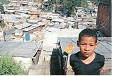
MIGUEL BOYAYANSome 45% of the cases of pneumonia in children occur in shantytowns or in areas nearby MIGUEL BOYAYAN
The city of São Paulo has 2,018 shanty towns, with a total of 1.16 million inhabitants living under precarious conditions of sanitation and housing. In these regions, or within a radius of 200 meters from them, live some 45% of the children hospitalized with a diagnosis of pneumonia in children in the accredited hospitals of the Single Health System (SUS). The most needy areas also concentrate of the elderly who are receiving lifelong monthly income – the pension paid to people aged over 65 who have never contributed to the Social Security -, as well as those who are receiving a disablement benefit.
And, in spite of the apparent statistical equilibrium between supply and demand in places in the municipal school network, there are still children out of school there. The Secretariat for Social Assistance (SAS) of the Municipality of São Paulo now has a way to identify these enclaves of poverty, through the Map of Social Vulnerability and Deficit of Attention to Children and Adolescents in the Municipality of São Paulo, drawn up by the Center of Studies of the Metropolis (CEM), one of the ten Research, Innovation and Diffusion Centers (Cepids) supported by FAPESP. “The map will be a strategic tool for implementing more efficient and focussed public policies”, explains Argelina Cheibub Figueiredo, the director of the CEM.
Levels of privation
The mapping of poverty, in a city with over 10 million inhabitants, is a complicated task: it calls for consolidation, updating, digitalization and collation of information scattered over distinct databases. The mapping of the perimeter of the shanty towns and the estimate of the resident population, for example, were done using an analysis of 8,500 aerial photographs and 800 physical inspections carried out by researchers from the CEM and the Municipal Secretariat for Housing.
The identification of the areas with a greater incidence of pneumonia in children, of the place of residence of those receiving lifelong monthly income and disablement benefit, just as the territorialization of the places at schools, was made possible by means of an analysis of data from the 13,000 census sectors identified by the Brazilian Institute of Geography and Statistics (IBGE) from 2000, from statistics from the municipal secretariats of Housing, Health and Social Service, and from information on public places. Georeferenced analysis made it possible to assess the statistical results in small areas, inhabited on average by 200 families. “The SAS wanted us to generate geographical information to make it possible to locate these people”, says Haroldo da Gama Torres, the coordinator of the CEM’s Geoprocessing and Information Technology Nucleus.
Breaking down the data for the areas of the municipality as a whole, the researchers were able to classify the population on the basis of its socioeconomic distribution in the urban space, taking 11 variables into account, such as income, schooling of the head of the domicile, and the presence of children and youngsters in the family, among others. According to these indicators, the population was classified into eight groups. The first of them covers the 6.3% of the population without any privation: it has the best conditions of income and schooling in the municipality, registers a low presence of children aged from 0 to 4 and adolescents, and is strongly concentrated in the southwestern region of the city.
But almost half the population of São Paulo (48%) is distributed over three groups classified as being of low, medium low and medium privation. They are older families, they have a low presence of children and youngsters, and the majority of heads of family have at least elementary schooling. They are concentrated on the southwestern and eastern regions of the city. At the other extreme to the first group, living in a situation of extremely high privation, are 3.8% of the inhabitants of São Paulo.
They represent around 420,000 families, living on the outskirts of the city, in families with a high concentration of children between the ages of 0 and 4 years and of youngsters from 15 to 19 years old, and the very bad indicators of schooling – 18% of the heads of families are illiterate and of income – 76% of those responsible for the domicile earn up to two minimum salaries (480.00 reals). The other 41.9% of the population is distributed over a slope between the 1st and 8th groups. The identification of the most vulnerable groups in the city of São Paulo is part of the first results of the research that is being carried out for the SAS. The next step will be to locate 420 domiciles with extremely poor families, Torres discloses.
Metropolization of São Paulo
The CEM was set up with the purpose of analyzing the recent consolidation of the process of the metropolization of São Paulo. The Map of Social Vulnerability lies within the scope of one of the targets: building up a georeferenced database, integrating information from various sources. With this perspective, the researchers from the CEM have now recovered, for example, the data of the Metropolitan Planning Company S.A. (Emplasa) and have swapped this information with the municipal town halls of the Metropolitan Region of São Paulo (RMSP), by means of contracts. “We have already provided services to the town halls of Mauá, Guarulhos and Embu (neighboring surbubs of São Paulo)”, says Argelina.
At the end of last year, the CEM launched a CD-ROM with digital cartography, data from the IBGE’s censuses of 1991 and 2002, and the Populational Count of 1996 for 21 municipalities of the RMSP (see issue n° 80 of Pesquisa FAPESP). The digitalization of the data was carried out by the State Data Analysis Foundation (Seade), a partner of the CEM. And the center is now beginning an understanding with the Municipal Urbanization Company (Emurb), which may guarantee the participation of the CEM in a project to revitalize the center of the city of São Paulo.
The CEM is made up of the Brazilian Center for Analysis and Planning (Cebrap), the Seade Foundation, the College of Architecture and Urbanism and the Communication and Arts School, both from USP. Besides the georeferenced database, the Center is running ten research projects in the areas of politics and public policy, culture, sociability and religion and urbanism. There are projects under way on family configurations in Greater São Paulo; new forms of employment in the metropolitan São Paulo and occupational mobility in the metropolis; an analysis of the pattern of the distribution of votes at the different levels of representation; environmental conflicts in the metropolis, among others. In the area of sociability and religion, for example, the researchers are mapping out all the places of worship in the city of São Paulo. “The evangelists have a strong activity on the outskirts. We may be able to associate a religious pattern with an electoral and associative pattern”, says Torres.
Republish