
When he first arrived in the Amazon for urban planning work in the rural parts of Rondônia, in 1973, Minas Gerais architect Roberto Luís Monte-Mor found that his education was not enough to explain what he saw: the impossibility of distinguishing clearly between urban and rural spaces, which seemed to merge together. Hence, one of his main theoretical contributions: the concept of extensive urbanization—the extension of the urban fabric into the countryside, forming hybrid spaces—which has been identified in recent decades throughout the country.
A professor at the School of Economic Sciences and at the School of Architecture of the Federal University of Minas Gerais (FCE-EA-UFMG), Monte-Mor has been coordinating, since 2009, the UFMG team that assists in the metropolitan planning of Belo Horizonte, helping to prioritize expenditures. In one of his courses at the School of Architecture, his students visit municipalities and help implement actions defined in the master plan. Monte-Mor both incorporated and expanded the concept of green and blue grid, which he brought from France: it consists of integrating and enhancing green areas and watercourses in cities, and it has been used in the reformulation of the Belo Horizonte Metropolitan Area.
A native of Conselheiro Lafayete, with Portuguese and indigenous ancestry, he sang bass at UFMG’s Ars Nova choir, and later with the Glee Club, the men’s chorus at UCLA, while getting his PhD. Monte-Mor has a son, psychologist Diogo, and a grandson, who both live in Portugal. He talked to Pesquisa FAPESP in June at UFMG.
Specialty
Urban planning
Institution
Federal University of Minas Gerais (UFMG)
Education
Undergraduate degree in architecture (1970) from UFMG, master’s degree in urban and regional planning (1980) from the Federal University of Rio de Janeiro (UFRJ), and PhD (2004) from the University of California in Los Angeles (UCLA)
Scientific production
35 articles
What is the university’s role in the elaboration of Belo Horizonte’s metropolitan planning?
The metropolitan plan was first discussed in the 1990s, but it was in 2008 that negotiations began to implement it. The first part, the Integrated Development Plan of the Belo Horizonte Metropolitan Area, was approved by the state government in 2011. On the university side, this work involved 57 professors from 14 areas, 80 undergraduate and graduate students, and 20 technicians. We combined two approaches: a comprehensive view, as was requested, and strategic planning, which meant setting short-, medium-, and long-term goals. The result was that the 28 larger public policies were broken down into 96 programs, each with their own set of tasks, agents, and legal norms involved. From 2013 to 2015, we did the metropolitan macro-zoning, which was one of the programs in the master plan. There were no federal guidelines to follow at the time, because no other work of this kind had ever been done in Brazil. Along with the Metropolitan Agency, we established that the macro-zoning would create Metropolitan Zones of Interest, defined in collaboration with the municipalities and which have clear geographical boundaries, and Metropolitan Areas of Interest, which do not have clear boundaries and define spaces for implementing priority policies such as housing. And now, from 2016 to 2019, we have been working on reviewing the metropolitan plans of 11 out of the 34 municipalities in the metropolitan area that have adhered to the conditions we proposed.
What are the conditions?
The municipalities would have to create a monitoring group, formalized by decree of the mayor, as well as a platform for the plan so that anyone may follow what is being done. Each group is made up of 12 to 16 members, half of whom belong to city hall and half from civil society. Conflicts sometimes arise within this group, such as between municipalities linked to real estate and the members of the group concerned about environmental issues. We continue to work with the groups through a course I created about four years ago at the School of Architecture, called Lumes.
What is this course?
It is an experience born of a program for the implementation and expansion of the master plan, called Lumes: Lugares de Urbanidade Metropolitana (Places of Metropolitan Urbanism), which is part of a policy for the democratization of metropolitan spaces. This program was inspired by the proposal by Gilberto Gil [Minister of Culture from 2003 to 2008] and Célio Turino [Secretary of the Ministry of Culture from 2004 to 2010] about points of culture that could activate Brazil’s social body. This course is taught on Saturdays and is open to students of any field. In January, a colleague and I talked to the monitoring groups. Then, we brought the students to the municipalities, where they are discussing with the population what can be done. We are working in three municipalities. One of them is Matosinhos, where the goal is to build a park. The architecture students are designing inexpensive exercise equipment, picnic areas, trails, and entrances. Another is Nova União, whose youth community works closely with city hall, where we are developing a recycling project. The third is Vespasiano, near the airport, which is experiencing a very large influx of new residents. There, we are using a library to gather residents and promote the reappropriation of cultural spaces. In yet another town, Raposos, the architecture students are working on recovering an architectural ensemble near a church. One of their community leaders asked that the town be included in Lumes, and the town priest offered his house as a place for the students to stay. It is a long-term project that contributes to the students’ education, but the limitations are great. In Ribeirão das Neves, we helped a hip-hop community reappropriate a building; but when the mayor changed, the project was canceled. But some of the students who participated in the debates took the entrance exam and were accepted at UFMG.
How did the university get involved in the metropolitan planning of Belo Horizonte?
Professor José Abílio Belo Pereira was part of a state government agency responsible for the metropolitan plan, and he was also a member of the Metropolitan Council, which included university representatives. In September 2009, he invited us to meet with people from the Secretariat for Regional Development and Urban Policy about a possible collaboration with the university. We set some restrictions. We weren’t interested in simply putting together a plan. For us, this work has always been a set of studies for the planning, which we saw as a permanent thing. We wanted the results to serve the government, civil society, and businesses.
We wanted the planning to serve everyone: the government, civil society, and businesses
What problems did you encounter?
The Belo Horizonte Metropolitan Area has a population of approximately 5.5 million, of whom 2.5 million live in the city itself. Some industrial municipalities located in the outskirts, such as Contagem and Betim, as well as more leisure-oriented municipalities, such as Nova Lima and Lagoa Santa, where you’ll find country homes and condos, have grown significantly. But there was a large contrast in quality of life: Belo Horizonte concentrated most of the services and the suburbs were fragile and underdeveloped, much like in Rio de Janeiro and other metropolitan areas. São Paulo is the opposite, as it has strong suburbs. We had to reverse priorities, seek balance, and invest in the suburbs. Now things are changing because we have strengthened small municipalities. The Ministry of Cities determined that intense involvement of the population be one of the conditions in the elaboration of metropolitan plans. We added elements from the theory of planning, inspired in particular by a PhD professor of mine, John Friedmann [1926–2017], from UCLA. When I was there, he published a book, Planning in the Public Domain: From Knowledge to Action [Princeton University Press, 1987], about the great trends in urban planning. The dominant one is what he calls top-down, state-centered social reform. He describes two other trends: social mobilization—of Marxist and anarchist origin—which sees the state as the enemy, and social learning, which we directly adopt, and according to which planning is no longer exclusive to the state and is partially passed onto the population. In this approach, we assume that techno-scientific knowledge is equivalent to the knowledge generated in everyday life. The planner learns from the citizen and vice versa. What we proposed, backed by the City Statute, was to plan from the bottom up, transforming citizens—as much as possible—from objects into subjects within the planning process.
Did it work?
Within the limitations, yes. The participatory process was very intense, but there were reactions too. In 2009, during my first plan presentation, a contractor who was a member of the Metropolitan Board asked, “Do you intend to plan just for the poor? If it wasn’t for the involvement of CEDEPLAR [Center for Development and Regional Planning at the School of Economic Sciences at UFMG], I would be very concerned.” Communicating with businesses, particularly mining companies, was very difficult. The mining companies do not participate in the debates, despite the impact of iron mining. There are more than 40 dams in the metropolitan area.
What changes did you propose?
Creating a compact polycentric metropolitan region, leaving aside the initial concept of a dispersed monocentric region. Belo Horizonte remains the main core, but we proposed three metropolitan centers: one in Betim, another one up North, near the airport, and a third one in the South, by the exit to Rio. There are also eight metropolitan subcenters—which have become metropolitan zones of interest—micro-regional centers that support rural activity, and development axes along federal and state roads. We try to reduce the urban perimeter as much as possible to avoid the spread of urbanization and overvaluation of the land, which pushes the poor further to the periphery. In the city plans, we create transition zones from rural to urban areas. They are still rural, but they’re already approved as likely to become urban. It is a solution to conciliate the interests of real estate and of the municipalities. Landowners have to pay to acquire a land use change permit, but it is simpler than having to approve changes to the master plan at the Metropolitan Agency. In this case, the change is already approved in the master plan. In Baldim, Vespaziano, and Nova União, this idea has already been completely approved; in other municipalities, it caused so much fighting in the monitoring group that the Public Prosecution got involved.
How did the concept of green and blue grid come about?
In 2008, the Minas Gerais government made a deal with the regional government of Nord-Pas-de-Calais, a coal-mining region in northern France. In the 1990s, the French government shut down coal production and huge piles of mining waste were left behind. They look like pyramids, and became a tourist attraction. The region was able to rebuild, and today it is home to a new railway station for high-speed trains, Lille-Europe, which connects to England and other European countries and stands alongside the old station, Lille-Flanders. After the agreement between the governments, UFMG made a cooperation agreement with the University of Lille and we started interacting. I visited the area several times and got familiar with the green grid process; they then incorporated the blue aspect and it became the trame vert et bleue, which they used to create tourist routes. In 2011, we incorporated this concept, consisting of the revaluation of green areas and watercourses, and gave it a dimension that I call lefebvriana [after French sociologist Henri Lefebvre, 1901–1991], which sees the urban as a space for celebration and connection. In the metropolitan plan, the green and blue grid labels conservation units, as well as state, municipal, and federal parks implemented or planned, the hydrographic network, points of culture, churches, caves, waterfalls, all still with a great degree of abstraction. In the city plan, each municipality has its own green and blue grid map, which includes conservation areas, pedestrian and cyclist paths, linear park proposals, and social connecting spaces. Based on this concept, we implemented green corridors, linking city parks in metropolitan areas of interest. The population strongly supported this and the grid became a staple of metropolitan planning. The proposals are now in each municipality; they should become bills, but they will only move forward if the population, the government, and businesses buy the idea and help implement it. We have to raise participation as much as possible. Similar concepts and applications exist in the green corridors of Campinas and São José dos Campos, in the state of São Paulo. The city of Rio Branco, in the state of Acre, has implemented a 6-kilometer-long linear park and is planning another, extending from the airport to the city.
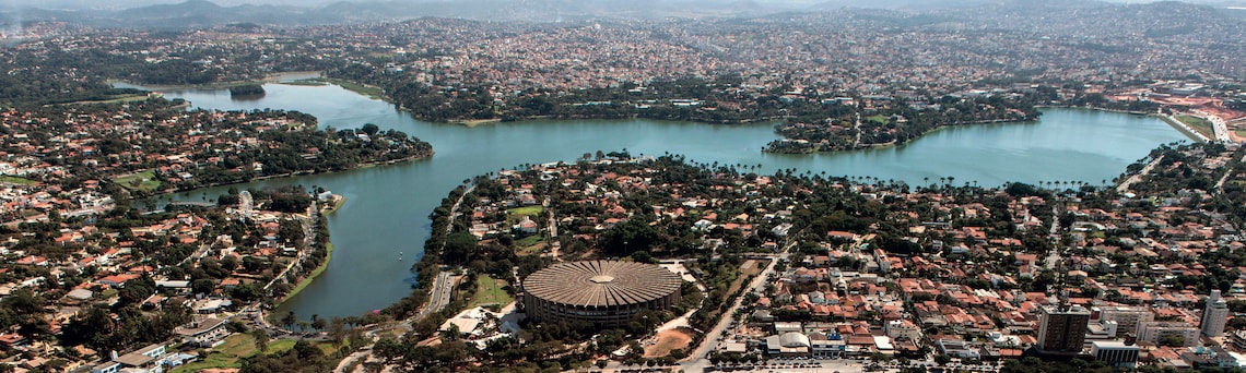
Rodrigo Lima / Wikimedia commons
Belo Horizonte, featuring Lake Pampulha and Mineirinho ArenaRodrigo Lima / Wikimedia commonsHow did you come up with the idea of extensive urbanization?
I was a monitor at the João Pinheiro Foundation and used to work with professor and sociologist Teodoro Lamounier [1939–2018]. In 1972, he told me that they were setting up the first urban-planning program in Brazil to train people to work on metropolitan plans. He asked if I wanted to be admitted into the program—on the condition that I come back and work with them later. The program was offered by UFRJ [Federal University of Rio de Janeiro] and it was great as it had students and teachers from all over the world. When I returned a year and a half later, the metropolitan plan had been assigned to another agency, and the foundation began offering services to the federal government, especially to the Amazon agricultural frontier. And I was sent to plan a village in the then Territory of Rondônia, at the time called Vila Rondônia—nowadays called Ji-Paraná. They believed it had a population of 6,000, but I discovered it was actually 14,000. I learned that everyone had moved there because of land, even though no one wanted to leave the city and lose access to education and urbanism. The settlers were given a living allowance to build their houses until they started producing, but they had to clear the forest and plant rice, while dealing with very poor roads and long distances. I saw so many people offering bags of rice to pay for a bus ticket to take their child to the doctor in town. The agriculture-based economy was fragile. What kept people from leaving were urban activities—like the woman who did the laundry at government officials’ homes and stayed in town because she wanted to keep her children in school. I came back after four months with my mind completely changed. The federal government had created the CNPU [National Commission for Urban Policy] to regionalize urban planning and hired me to plan Rondônia, which was going to become a state. In 1976 and 1977, I visited all of Rondônia in order to do this work. In 1979, I had to write my master’s dissertation in three months in order to teach at CEDEPLAR, where I had been hired. I reflected on this whole process and showed that the people at the frontier could not do without an urban base. It was clear to me that there was a movement towards expanding the urban space that went beyond the frontier. No one went anywhere without motor vehicles, so the vehicle and motor services network was huge.
What are the implications of this concept?
It is a process of urbanization that grows far beyond cities, integrating rural and regional areas with urban and industrial space through the expansion of services and infrastructure. It is as if the city spread its tentacles over the countryside, because everyone wants electricity and internet access. As a result, hybrid spaces are formed: neither city nor country. The expansion of the urban fabric consolidates the capitalist forms of production, because the rural residents will have to work to buy their cell phones. It also brings them the beginnings of polis, politics, and civitas, or citizenship. Those who live outside the city, beyond wanting comforts also want legislation, minimum wage, social security—in conclusion, citizenship. Indigenous, landless workers, those affected by dam bursts, coconut breakers, gold prospectors, and rubber tappers have become politicized; they have organized into social movements and have reached the whole territory. Over the past 30 years, extensive urbanization has reached practically the entire country, from metropolitan areas to industrial centers, raw material sources, transport networks, energy, and communications. By the end of the twentieth century, production of space on the Amazon and Central-West frontiers was already occurring through an urban-industrial base emanating from the metropolitan centers and their spin-offs in the agrarian areas linked to the country’s agro-industrial base.
The expansion of the urban fabric toward the country also brings the beginnings of polis, politics, and civitas, or citizenship
When did you consolidate this approach?
During my PhD at UCLA. My advisor was geographer Edward Soja [1940–2015]. Despite my seemingly typical background in architecture, having specialized in urbanism and pursued a master’s and a PhD in urban planning, I actually have a transdisciplinary background. During my specialization, I came close to sociology, and during my master’s, I was fascinated with economics—both my advisor and my examiners were economists—and while getting my PhD I got involved in geography—my advisor and my board were all geographers. Soja was starting to read Lefebvre, with whom I was already familiar. The term “extensive urbanization” came up at the beginning of my PhD. I presented it at a meeting of geographers in 1987 in Baltimore, United States, and again the following year at a conference in Puerto Rico. My first interlocutors were members of an Amazon study group here at CEDEPLAR led by Donald Sawyer. They kept asking if I was talking about precarious urbanization, about peripheries; they hadn’t read Lefebvre in depth and couldn’t understand…
Is this concept present in Lefebvre’s works?
Not in that same way. In his 1968 book, The Right to the City, he states: “A political practice is emerging in cities that no one is noticing, and it will transform everything;” it is the fight for the city over the fight for housing. He claims that the idea of housing as something separate from the city is a strategy of the bourgeois class to remove the working class from the space of power, of celebration, of collective wealth—which are the functions he assigns to cities. In The Urban Revolution, published in the 1970s, he describes the process of urban explosion and implosion. Industrialization transforms the city into a production unit.; As a result, what used to be the old city implodes and verticalizes, as occurred in Manhattan—the ultimate expression of this process. And the rest explodes into something that is basically meant to reproduce the workforce. It is not the city, because it is not the space of celebration, wealth, and power, but simply that of housing and reproduction. According to Lefebvre, this urban fabric that follows the industrial city and extends to the countryside and the entire social space is virtually planetary: it will reach the entire world.
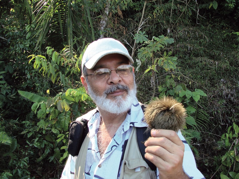
Personal archives
In Machadinho do Oeste, Rondônia State, in 2010, holding a pente-de-macaco (Apeiba tibourbou)Personal archivesDo you agree with that?
I do. Last May, I visited a colleague in India and saw the state of Kerala, with a population of 30 million, a quality of life equivalent to that of Europe, and an economy based on agriculture, services, tourism, and Ayurvedic medicine, where rural and urban spaces have already blended completely. A lot of people are discussing these phenomena. A Harvard professor, Neil Brenner, asked to translate and publish two of my works in a compilation he published in 2014, Implosions/Explosions: Toward a Study of Planetary Urbanization, which has brought high visibility to this debate. One of the texts had come out in 1994 in a book organized by geographer Milton Santos [1926–2001], Território, Globalização e Fragmentação (Territory, globalization, and fragmentation). This 1994 work of mine was the first to be more widely publicized out of the ones in which I claimed that extensive urbanization would necessarily correspond to extensive naturalization. It is the joining of the city with nature, or the natural urban. After the book, I gave a presentation at a University of São Paulo (USP) seminar organized by Milton Santos. My opponent in the debate was a famous geographer, Pedro Geiger. He said, “This is very weird, it makes no sense.” Milton supported me: “Don’t worry about the criticism, you have to dare to think.” At the time, people didn’t understand what I was talking about, but now they do. A friend who lives in London shared that, when he visits people’s homes, there are no places to sit—just plants. Kids who live in apartments even have worm farms.
After your work in Rondônia, did you ever return to the Amazon?
I never stopped going. During my PhD, I went all the time to examine the urbanization processes in Rondônia, northern Mato Grosso, southern Pará, and northern Tocantins. I visited Machadinho do Oeste, in Rondônia, for the first time in 1984, during a project with colleagues from NAEA [Center for Advanced Amazonian Studies at the Federal University of Pará]. We followed the settlers’ entrance into collective reserves, which later became extractive reserves. Every July we took 15–20 students and spent the whole month interviewing everyone. After that, I went back in 2005, 2007, and 2010.
What has changed there?
Nowadays Machadinho is a city. The economy is consolidated, producing coffee, cocoa, and cattle. In 2010, a man from Paraná said to me: “When I first came here I was scared of the forest; I couldn’t wait to cut it all down. Now I go back to Paraná and I’m sorry to see what it’s like over there, and I see that our wealth here is the forest.” They are learning how to plant underneath the trees of the forest. While doing other research, I examined the nature of the urban in three extractive reserves: one on dry land in Acre; one on the riverside, near Santarém, in Pará; and the marine reserves on the coast of Pará. I spent a week in each location. The way residents see the urban space depends on their relative position. If they are near the city, they just want schools, health posts, and support for their production; they do not want urban services because they claim that with them comes the “bulixo,” meaning small taverns or “botecos,” as they call them, and bullets. If they are further away, they have better control over this interaction.