
Ricardo ZorzettoAt the forefront of global astrophysics: the Soar and Gemini (at rear) telescopes in the Andes; Brazil is a partner in bothRicardo Zorzetto
In the early afternoon of November 17, 2014, Igor Gil Pacca ran into Gelvam Hartmann in a hallway at the Institute of Astronomy, Geophysics and Atmospheric Sciences (IAG), and preempting any questions, he said politely, “I’m looking at your work.” Pacca, who at 85 is one of the oldest professors at the Institute—“I come here every day”—was referring to a scientific paper they were preparing, but in a deeper sense, his comments called to mind a network of people, aspirations, equipment and institutions that started to come together at least half a century ago.
Hartmann, a 35-year-old physicist currently doing post-doctoral research, is working on paleomagnetism, a technique for analyzing variations in the Earth’s magnetic pole and ascertaining the magnetic poles of rocks thousands or millions of years old. As a member of the team headed by his former doctoral thesis advisor, Ricardo Trindade—whose own thesis advisor, Márcia Ernesto, did her doctoral studies under Pacca’s advisorship—Hartmann spends much of his time in the paleomagnetism laboratory, examining samples of bricks to discover, confirm or correct data on old buildings in Brazil and neighboring countries, and associating them with their respective magnetic intensities. In one of his studies, he identified a possible date–between 1561 and 1591—for one of the oldest structures in Brazil, the Cathedral of São Salvador, in the capital city of Bahia State (see Pesquisa FAPESP Issue No. 185).
Photos Astronomy and Astrophysics Institute – Paulo Marques dos SantosFirst measurements: meteorological station atop the tower in Jardim da Luz Botanical Park, in operation from 1888 to 1894Photos Astronomy and Astrophysics Institute – Paulo Marques dos Santos
Pacca was one of the first researchers to enter this field in the 1960s, when new ideas such as tectonic plate theory lent substance to the field of geophysics. He was still at the Physics Institute, where he had pursued his undergraduate and doctoral studies with Cesar Lattes. Then as a professor, he set up one of the first paleomagnetism laboratories in Brazil, in 1971, at the Physics Institute of the University of São Paulo (IF – USP). Two years later, he transferred the equipment back to IAG and moved there as a professor, on an invitation from its first director, Giorgio Giacaglia, to train a group of researchers in geophysics.
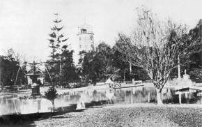
Pacca had a hand in establishing and organizing IAG, and its origins hark back to American geologist Orville Derbi, engineer Theodoro Sampaio, Swedish botanist Alberto Loefgren and other former heads of the São Paulo Geography and Geology Commission, who expressed an interest in studying the climate of the state of São Paulo in the late 19th century in order to identify the most suitable terrain for growing coffee. The meteorological and astronomical instruments were installed in a wooden tower in Jardim da Luz Park, and later on the roof of the Normal School on Republic Square, then in a house on Paulista Avenue, next to the present-day São Paulo Museum of Art—where the seismograph was unreliable because of vibrations from streetcar traffic—until it was given a more suitable home in Água Funda Park.
Promise fulfilled
In the late 1960s, the then-director Abrahão de Moraes wanted to take advantage of university reform to transform IAG from an adjunct institute into a teaching unit, but he died in 1970. “At de Moraes’ funeral, University President Miguel Reale commented, “‘Abrahão, I’m going to fight for that institute you wanted,’” said Pacca, who witnessed the moment. “ Much of the existence of IAG as a USP teaching and research unit,” he added, “is tied to those words at that moment in time.” IAG gained the desired status of teaching and research unit of USP soon afterwards, in 1972.
A short time later, Pacca invited physicist Marcelo Assumpção, who was then at the Physics Institute, to hire on at IAG, then do his doctoral studies in seismology at the University of Edinburgh in Scotland, and subsequently join the group of geophysics professors at IAG. Assumpção went, came back and taught a lot of classes. His research work included examination of the variation in thickness of the Earth’s crust in Brazilian territory, in collaboration with colleagues from other Brazilian universities. Their work has yielded a compilation of data that help predict and explain earthquakes. One of his current endeavors involves strengthening the Brazilian seismographic network, which consists of institutions in several Brazilian states. The network, now in the final stage of installation, will monitor Brazil’s entire territory and generate data on the Earth’s internal structure.
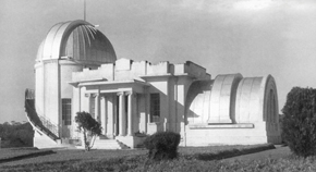
Photos Astronomy and Astrophysics Institute – Paulo Marques dos SantosIAG in a home of its own: one of the buildings of the São Paulo Astronomical Observatory in 1947, in the Água Funda neighborhoodPhotos Astronomy and Astrophysics Institute – Paulo Marques dos Santos
Pedro Leite da Silva Dias and his future wife, Maria Assunção Faus da Silva Dias, having recently graduated with degrees in mathematics, also went abroad for their graduate studies—in this case, atmospheric sciences in the United States—and then joined the group of professors at IAG. They went on to lead research groups in meteorology and climate change. In addition to his extensive scientific work, Dias is director of the National Scientific Computing Laboratory (LNCC) in Petrópolis, Rio de Janeiro State. After seven years in the position, he misses teaching and looks forward to a time when he can return to the classroom. “USP is the closest thing to the fountain of youth,” he commented. “Teaching class and discovering talented new students! And nurturing them….”
Taking the long view
In 1974, recent physics graduate João Evangelista Steiner began his master’s studies with José Antônio de Freitas Pacheco, one of the physicists whom Abrahão de Moraes had sent off to pursue graduate studies in France. Upon his return, Pacheco established the graduate program at IAG, “an important step that accelerated the strengthening of the astrophysics program, because the students no longer needed to leave Brazil for their graduate studies,” said Steiner, who has become one of today’s leading figures in astrophysics research in Brazil.
Upon his return from graduate studies in the United States in 1982, Steiner became involved in long-running battles in support of improved infrastructure conditions for astronomy research. The first battle involved the creation of the National Astrophysics Laboratory (LNA), “for all Brazilian astrophysicists to use on an equal basis,” he said. The LNA opened the way for the formation of a strong community of astrophysicists, and this enabled Brazil to use two international telescopes—the Gemini and the Soar—that today are at the forefront of astronomical research.” Steiner, along with Jacques Lepine of USP and colleagues at other institutions, was involved in the negotiations for Brazil’s participation in the Gemini and Soar observatories, both of which are in operation in Chile.
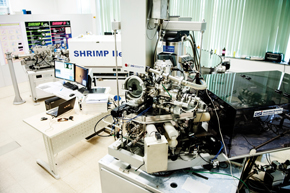
Léo RamosUnique instrument in South America: SHRIMP determines the age of mineralsLéo Ramos
“We are now beginning a new phase in Brazilian astrophysics,” says Steiner, referring to the building of the Giant Magellan Telescope (GMT), on which FAPESP-supported construction will begin in 2015 in the Chilean Andes. The GMT is expected to enter into full operation in 2021, with a light-collection area 100 times greater and spatial resolution 10 times greater than that of the Hubble space telescope. “We’re leaving a legacy for future generations of astrophysicists.”
Several examples illustrate how the researchers in IAG’s Department of Astrophysics are taking the long view. Beatriz Barbuy identified some of the oldest stars in the Milky Way—12.5 billion years—and Augusto Damineli, after a tenacious, decades-long effort, explained the structure of the star Eta Carinae. Joined by his team, Damineli explained possible reasons for why it loses light every five and a half years (see Pesquisa FAPESP Issues No. 203, 206 and 191).
The ages of South America
Many professors at IAG work collaboratively with those at the Geosciences Institute (IGc), which had its origins in the geology curriculum offered at the Alameda Glete Mansion, one of the first USP facilities, formally established as an independent teaching unit in 1969 and now located on the main campus in São Paulo. “We started out together,” says Umberto Cordani, a geologist who taught classes in the early days at IAG while he was helping to set up the first laboratories at his own institute, IGc.
Cordani still works quite a bit at the age of 76. In July 2014 he went to Rio Branco, in the state of Acre, to speak at one of the presentations at the annual meeting of the Brazilian Society for the Advancement of Science (SBPC), about deep-focus earthquakes, based on the work of Marcelo Assumpção. These earthquakes originate 600 kilometers (km) beneath the Earth’s surface and can be felt as far away as western Amazonia. Cordani oversees studies such as the one by his doctoral student Carlos Ganade de Araujo, now a researcher at the Geological Survey of Brazil, whose thesis resulted in an article published in Nature Communication in October 2014. In the paper, Araujo, Cordani and other geologists suggest that the erosion of a chain of mountains at least 2,500 meters long across the Brazilian Northeast and West Africa may have produced the nutrients necessary for the hitherto poorly explained explosion of life forms that occurred 600 million years ago.

LÉO RAMOS
IGc and IAG professors from several generations: (standing, from left) Celso de Barros Gomes, Vicente Antonio Vitorio Girardi, Adolpho José Melfi, Antonio Carlos Rocha Campos, Georg Robert Sadowsky, Benjamim Bley de Brito Neves, Umberto Giuseppe Cordani and Igor Ivory Gil Pacca; (seated) Setembrino Petri, Kenitiro Suguio, Marta Silvia Maria Mantovani, José Moacir Vianna Coutinho and Jorge Silva BettencourtLÉO RAMOSThe rock samples from Africa and Brazil used in this study were analyzed at the High Resolution Geochronology Laboratory—a mirrored-glass building to the right of the IGc entrance—in an instrument known mostly by the name SHRIMP (Sensitive High Resolution Ion Microprobe). The laboratory, opened in 2010, is one of the most sophisticated mineral-dating facilities in South America, and it represents the continuation of geochronology, a line of research that Cordani and physicist Koji Kawashita began to develop 50 years ago and that now constitutes one of the Institute’s principal research areas, along with other subjects such as primitive life on Earth, with the groups led by Thomas Fairchild, Claudio Riccomini and Marly Babinski, to name a few.
In 1964, Cordani and Kawashita were all but new graduates when they joined the first team at the recently-inaugurated geochronology laboratory—now the Center for Geochronology Research, located on Alameda Glete Avenue—through a U.S. National Science Foundation (NSF) grant awarded to John Reynolds of the University of California at Berkeley. “The laboratory was the seed of everything that has happened since, and a lot has happened,” Cordani said.
Using rock sample dating analysis and paleomagnetism measurements, researchers from IGc, including Benjamim Bley de Brito Neves, Wilson Teixeira and Colombo Tassinari, and from IAG, such as Igor Pacca and Manoel D’Agrella, have reconstructed the geological history of ancient supercontinents that have since broken apart, such as Rodínia and Gondwana, and the still-visible South America, formed out of rocky cores 3 to 3.5 billion years old that are now located in the states of Bahia and Pará. These were joined by other, newer, blocks of rock 600 million years old that now form much of the Brazilian Northeast, Southeast and South, as well as other, even more recent rocks 10 million years old, such as the ones found in the Fernando de Noronha Archipelago (see Pesquisa FAPESP Issue No. 188).
Climates of the past and present
Researchers at IGc are also working with colleagues at the Biology and Oceanography institutes to reconstruct climate changes that have occurred in South America on a more modest time scale, the last few thousand years. Geologist Francisco Cruz, a member of the new generation of professors and researchers at IGc (he was hired in 2009), is studying the variation in the ratio of oxygen isotopes in cave rocks in order to see, for example, how rainfall has fluctuated with respect to summer solar radiation and climatic conditions over the oceans, from thousands of years to just a few decades ago (see Pesquisa FAPESP Issue No. 111).
Anyone doing climate research today cannot forget Carlos Augusto de Figueiredo Monteiro, a geographer who helped lay the foundations of climatology in Brazil, encapsulated in the book Clima e excepcionalismo [Climate and exceptionalism] (Ed. UFSC, 1991). This and other books are the culmination of 40 years of pioneering work completed in 1987, when Monteiro retired from USP (see Pesquisa FAPESP Issue No. 171).
The Department of Geography had its roots in France, inasmuch as its first professors in the 1930s were the Frenchmen Pierre Deffontaines and Pierre Monbeig. Today the Department continues to be home to researchers and professors who study not only climate, but also the forms of, and potential for, land occupation in Brazil. They use mapping surveys or conceptual approaches, such as those offered by geographer Milton Santos (who died in 2001 at the age of 75) in a series of books including A natureza do espaço [The nature of space] (Hucitec, 1996), and by Antonio Carlos Robert de Moraes, who also authored books now regarded as essential, such as Geografia: pequena história crítica [Geography: A small critical history] (Hucitec, 1994) and Ideologias geográficas – Espaço, cultura e política no Brasil [Geographic ideologies – Space, culture and politics in Brazil] (Hucitec, 1988).
Types of terrain
In the next few months, the government of the state of Paraná is expected to unveil its ecological and economic zoning plan. The plan will delimit the areas of the state that will be zoned for industry, farming, and cities, “based on the potentialities and fragility of each region,” said Jurandyr Ross, a geographer and professor at USP who was a member of the team that drew up the plan.
Ross started as a professor hired in November 1982 when he replaced Aziz Ab’ Saber, who had retired three months earlier (Ab’ Saber died in 2012), and took over his geomorphology laboratory. Utilizing knowledge gained from the 15 years he spent on the Radambrasil project, a pioneering mapping survey of the entire Brazilian landmass, Ross reworked Brazil’s terrain classification system, and in 1990 he published his own version, more detailed than Ab’ Saber’s which had been widely circulated since 1958 and had itself succeeded an earlier 1940s version by Aroldo de Azevedo, a USP professor and author of textbooks used widely in elementary and middle school.
Ross developed a classification of terrain types, with six taxons or units of classification, from the general to the specific. This approach was used initially in a geomorphological mapping survey of the state of São Paulo with his USP colleague Isabel Cristina Moroz, and presented in 1998 (see Pesquisa FAPESP Issue No. 35). “This terrain taxonomy was used later for the geomorphological map of the state of Paraná and in the Alto Paraguai Basin,” said Ross. In later years he was a consultant to the Ministry of the Environment, where he sometimes encountered his colleague Robert de Moraes, also a consultant—one more indication that the knowledge generated at USP was spreading throughout Brazil.
Republish