Hugo Pires / Universidade Do Porto – Amazônia ReveladaLidar virtually removes trees, as if with an X-ray vision, revealing “honeycomb” structures in Terra do Meio, ParáHugo Pires / Universidade Do Porto – Amazônia Revelada
“Indigenous knowledge is like archaeology: the more you dig, the more you find,” historian Soleane Manchineri, ombudsman at the Acre State Public Defender’s Office, told an auditorium full of researchers from across Brazil, relatives (as Indigenous people refer to each other), and representatives of other traditional Amazonian communities (quilombolas and beiradeiros). The phrase was emblematic of the meeting, which was held at Museu da Amazônia (MUSA) in Manaus from October 18 to 21.
The idea was to share the preliminary results of the Amazon Revealed project, which is led by archaeologist Eduardo Góes Neves of the Museum of Archaeology and Ethnology at the University of São Paulo (MAE-USP) and involves using a remote sensing technology called Lidar (light detection and ranging) to map the ground by bombarding it with thousands of laser beams. Funded by the National Geographic Society and with authorization from local communities, flyovers in areas impacted by deforestation and infrastructure were conducted for this study.
Lidar can be used to create a detailed three-dimensional image of a forest’s structure, with its trunks, branches, and leaves, as well as showing what is below that structure. This is what interests Neves, who wants to highlight the importance of the Amazon as a type of historical and biocultural heritage formed by the peoples of the rainforest over the last 13,000 years.
This researcher has worked in the region for almost 40 years and has witnessed deforestation and destruction on a major scale. She has also helped educate archaeologists, many originally from the Amazon region and several now working at universities and research centers in Brazil’s northern states. The project began in five areas where researchers with ties to Neves were already carrying out research in partnership with local communities, who agreed to join the initiative: Acre/Southern Amazonas, Middle Guaporé, Tapajós, Terra do Meio, and Marajó. Neves runs the project together with Brazilian archaeologists Bruna Rocha of the Federal University of Western Pará (UFOPA) in Santarém, Cristiana Barreto of the Emílio Goeldi Museum of Pará (MPEG) in Belém, Carlos Augusto da Silva of the Federal University of Amazonas (UFAM), Italian director of MUSA Filippo Stampanoni, and Morgan Schmidt, an American researcher currently doing a postdoctorate at the Federal University of Santa Catarina (UFSC).
The project is based at MUSA, which was founded by physicist Ennio Candotti and since 2011 has been situated in a 100-hectare area of the Adolpho Ducke Forest Reserve, just outside the capital of Amazonas. With spaces integrated into the forest, the museum presents aspects of the region’s flora, fauna, and human population. It was thanks to the Amazon Revealed project that the auditorium where the meeting took place was built. The space includes a display on Amazonian archaeology and another showing the early results of the project, as well as information about a technical reserve for storing archaeological, ethnographic, and fossil artifacts. “This has helped MUSA become a hub for archaeological research,” says Stampanoni.
The goal is to conduct collaborative, codesigned, and coproduced science with local communities. “The project is not ours; the demand for demarcation studies is theirs,” says Francisco Pugliese, an archaeologist from the University of Brasília (UnB). “We are just the instruments.” The informed consent essential to carrying out the research in each area comes from long and detailed conversations between archaeologists and inhabitants. Indigenous peoples’ knowledge also guides researchers to locations rich in history and helps them interpret their findings, an uncommon practice in academia.
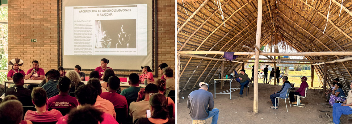
Christian Braga / Amazônia Revelada | Personal Archive Jupaú Community Tupari and Jupaú delegations at the meeting, held at MUSA, and a community meeting with the village of Alto Jaru, Rondônia, as part of the projectChristian Braga / Amazônia Revelada | Personal Archive Jupaú Community
Laser vision
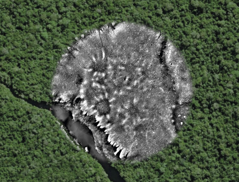
In Acre, the use of Lidar to view the ground beneath the forest has increased the number of known geoglyphs—enormous geometric figures that ancient peoples marked on the ground using ditches and walls, often interconnected by ancient roads. Flyovers have been conducted in the area, revealing that these archaeological sites, which are well documented in the southern part of the state, also exist north of the Purus River, including in the state of Amazonas. One of the newly documented geoglyphs is a square large enough to encompass the Maracanã stadium, with roads spreading out of two sides, as shown by Portuguese topographer and geometer Hugo Pires of the University of Porto, Portugal.
Pires joined the project recently, after hearing about it on an episode of the podcast Rádio Novelo Apresenta hosted by Letícia Leite, who is responsible for communication for Amazon Revealed. He works with documentation of archaeological heritage in several places around the world and has developed a method for processing Lidar data called the morphological residual model (MRM). With this technique, depressions and elevations captured in the microrelief by Lidar are colored, generating an image that reveals the complexity of the terrain with greater contrast, thus highlighting archaeological details.
The first person to spot geoglyphs in the Brazilian Amazon was paleontologist Alceu Ranzi, now retired from the Federal University of Acre, when flying into Rio Branco on a commercial flight in 1986. It took him almost 20 years to begin studying them. “In 2000, I realized that archaeologists were not working on this,” he says, and he began flying over the area to look for them. “Then came Google Earth. I spent hours on the computer looking for geoglyphs.” He was approached by Francisco Nakahara, who did not know him but had seen a documentary on the subject and wanted to look for the designs. Ranzi taught him how to find them, and Nakahara began sending him coordinates. “He is an 84-year-old man, and he has identified more than 300 geoglyphs,” says the paleontologist. Approximately one thousand geoglyphs have been recorded in deforested areas in the state.
A more surprising discovery was made in the municipality of Costa Marques, Rondônia, on the border with Bolivia. The region is home to Indigenous people and people of African origin in the quilombola community of Príncipe da Beira, descendants of slaves taken to build a fortress to defend against Spanish invasion at the end of the eighteenth century. The importance of the fortress declined over the nineteenth century and was eventually abandoned. According to Carlos Augusto Zimpel, an archaeologist from the Federal University of Rondônia (UNIR), the ruins contained European objects, such as crockery and cutlery. The building was listed by the National Institute for Historical and Artistic Heritage (IPHAN) in 1950. Lidar revealed the remains of a nearby Portuguese village, which was named Bragança on an eighteenth-century map, but the location of which was previously unknown. “I have walked by without noticing the village,” Zimpel said. Images of the terrain’s relief were used to reconstruct the layout of streets, identifying geoglyphs and ditches near the village that indicate a much older occupation, with remnants of ceramics near patches of terra preta (dark earth originating from indigenous soil management practices). “The Amazon Revealed project could stimulate archaeological tourism,” noted Santiago Cayaduro Pessoa, who lives in the community and works as a guide at the fort.
The Kuikuro of the Upper Xingu are partners in the archaeological study, but at first, they did not accept the airplane flyovers because they did not want data about their sacred sites to be made public. Instead, they have been collecting images in specific locations using a drone equipped with Lidar, which was piloted masterfully by the technical geographer Kumessi Kuikuro. “The Kuikuro have a glowing reputation in the Xingu Indigenous Reserve in terms of mapping, and they are often sought out by other ethnic groups,” says MPEG archaeologist Helena Lima. Under the agreement, the data collected belong to Indigenous people, who grant varying levels of access to the researchers.
One archaeological site near the village features mounds, ditches, squares, and roads. The ditches run to the river and connect all the sites in Upper Xingu, according to Schmidt, who has been working in the Amazon since 1998. Owing to the presence of terra preta, the intentional creation of which he recently described in coauthorship with Kuikuro Indigenous people, he believes that the mounds arranged in a circle were trash piles behind each of the houses. The houses, which were made of clay and wood, were unable to withstand the test time. However, the compost heaps were.
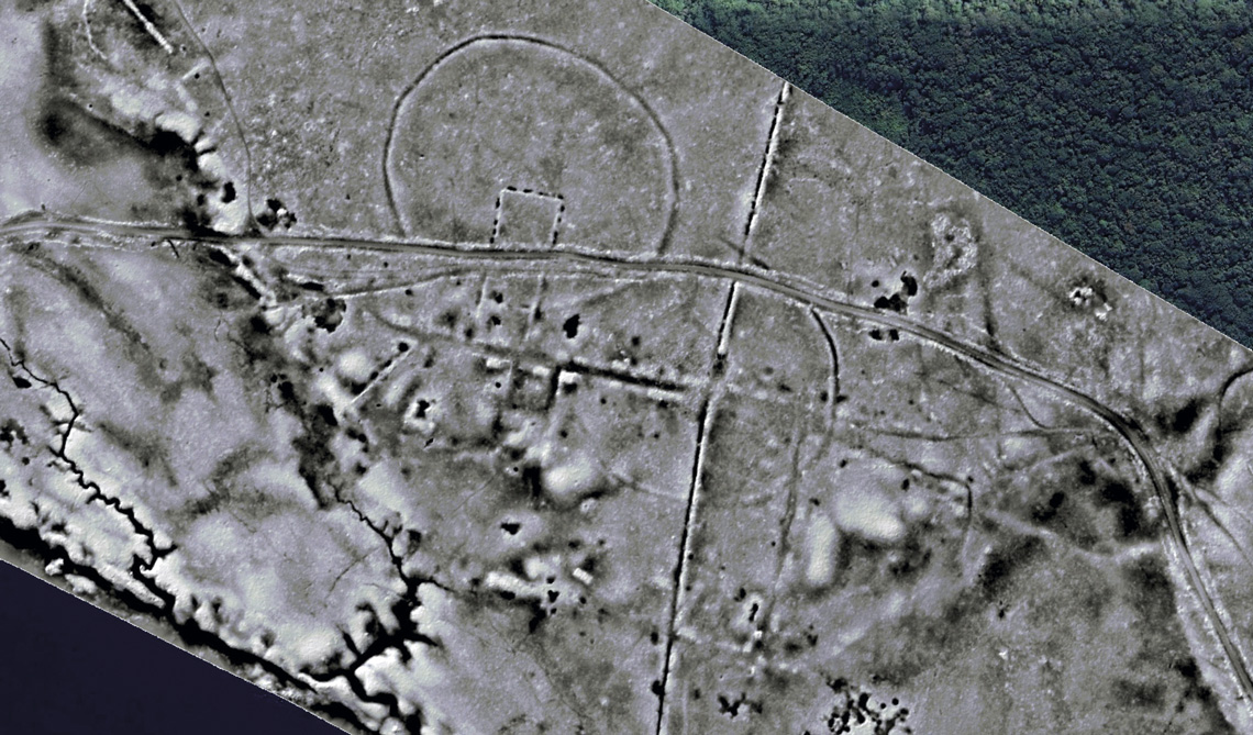
Carlos Augusto Zimpel / Unir – Amazônia ReveladaBetween two circular geoglyphs, straight lines and slight reliefs are remnants of the village of Bragança on the banks of the Guaporé RiverCarlos Augusto Zimpel / Unir – Amazônia Revelada
In the spirit of joint research between archaeologists and Indigenous groups and in support of decolonialism, all material excavated on Tupari land is being kept in the village of Palhal, Rondônia, where there are plans to create a museum. Three-dimensional scanning will be used to make replicas for researchers. One of the struggles faced by the inhabitants of Palhal is the demarcation of their land since the village is not within the contiguous Rio Branco Indigenous Reserve. “Our ancestors are buried there,” explains Adilson Tupari.
The findings may lead to meaningful approaches for protecting the rainforest and improving the lives of those who reside there, since archaeological sites are protected by the Brazilian constitution. “We gave IPHAN a good problem to solve,” jokes Neves, from the MAE-USP. The dilemma is that there is no mechanism to register archaeological sites on the basis solely of lidar images, and the technology has already begun to reveal more areas of interest than can feasibly be visited and excavated. The rules and regulations for registration need to be adapted and expanded, and even then, the problems will not be overcome. “Regulatory protection does not necessarily mean physical protection,” says archaeologist Thiago Berlanga Trindade, head of IPHAN’s Data Registration Service. The community and society need to be involved in oversight.
People living in rainforests—whether Indigenous, quilombola, or riverside communities—are facing urgent, violent threats. There have been reports of genocide, rape, deadly epidemics, roads being built through protected lands, river pollution, destruction of sacred sites, illegal farming (with monocultures of soy, maize, or rice), land grabs, logging, mining, and droughts resulting from climate change and hydroelectric dams. Climate change has been a more unexpected blow, in addition to the succession of violence experienced since Europeans arrived in the region. “We are experiencing a drought that my grandparents never thought they would see,” says Marquinho Castro dos Santos of the Mayoruna people. Santos teaches at the school in his village of Marajaí, which is located on the banks of the Solimões River in the municipality of Alvarães. Through this erosion of basic rights, they also lose access to their heritage. The beiradeira community—resulting from marriages between Indigenous people, descendants of enslaved people from Africa, and riverside people—from Terra do Meio, in southern Pará, is losing its history, with little access to education and no acknowledgment of the local culture. There is also a beiradeira community living on the banks of the Tapajós River in Montanha and Mongabal, as well as a representative of the Munduruku Indigenous people. The archaeologist Vinicius Honorato of the UFOPA has highlighted that archaeology helps strengthen traditional knowledge.
Antônio Enésio Tenharin, a municipal secretary for Indigenous Peoples in Humaitá, south of Amazonas, says that in the quest to recover and preserve their heritage, his people filed a civil suit in 2014, demanding the creation of a heritage center and the publication of educational material on the impacts that construction of the Trans-Amazonian highway had on the Tenharin and Jiahui Indigenous peoples.
The meeting in Manaus brought all of these groups together and reinforced archaeology’s position as an ally. “We are in this battle together,” said Vilson Tenharin, from the village of Marmelos in southern Amazonas. The four-day event was crucial to the formation of a network that the leaders intended to strengthen by promoting further meetings. They say that archaeological work needs to come from the peoples of the forest, including through the training of archaeologists of Indigenous, quilombola, and beiradeira origin.
Seen as a science that focuses on the past, archaeology has now presented itself as a window for thinking about (and safeguarding) the future. For researchers and people who live in the rainforest, the Amazon is not revealed; it is revealing itself.
The journalist traveled at the invitation of the Amazon Revealed project.
Published in December 2024.
Republish