Published in March 2011
 EDUARDO CESAR
Gravity is still exciting the imagination and leading to bewildering conclusions as it did for Newton. One example: someone traveling by ship from Cape Town, South Africa to Belém, Pará will go downhill without noticing it. Because of differences in the mass of the planet along the route between these two places – and, therefore, variations in the Earth’s field of gravity – the sea level in the port in the south of South Africa is 70 meters higher than the sea level in the port of Belém.
“No one notices this change in level because the distance between South Africa and Brazil is very large, almost 8000 km,” states geophysicist Eder Cassola Molina, a professor at the Institute of Astronomy, Geophysics and Atmospheric Sciences (IAG) of the University of São Paulo (USP). “Furthermore, the surface of the sea is curved, because our planet is approximately shaped like a sphere.” Last year he made a map of the South Atlantic that comes to these conclusions. He made the map to pass the public admission exam for full professor. Now a smaller A4 version is pinned to one of the cupboard doors in his ample laboratory.
Gravitational force expresses the physical attraction between bodies, which varies according to the mass. An everyday example of the action of this force is the tides. They are the result of the gravitational interaction between the Earth, the Moon and the Sun, which deforms the Earth on a daily basis. Capable of acting at any point in the universe, the force of gravity means that bodies in freefall close to the earth’s surface accelerate at approximately 9.8 m/sec2, i.e., the speed of their fall increases by 9.8 m/sec every second. The acceleration of gravity varies subtly at each point on the Earth according to the relief and density of the rocks because the distribution of the Earth’s mass is heterogeneous. This distribution gives rise to an interesting effect, as described by Molina: “The distribution of the mass of the Earth controls the level at which seawater is going to be found at a given instant, since the momentary surface of the sea adjusts according to the field of gravity. Therefore, we have highs and lows on the ocean’s surface. The sea level is not constant and varies with the weather and geographical location. In fact, there’s no such thing as sea level, but a mean level or momentary sea level.”
On one of his computers, Molina shows another map that details the variations in the height of the water along the coastline of Brazil. On this map, published in December 2010 in the Journal of Geodynamics, a red stain northeast of Brazil represents an area where the seawater must be 10 meters higher than in the areas that surround it, areas that are marked in green and blue. “With a map like this in your hands,” says Molina, “the pilot of a boat could skirt round the highest areas, even though he cannot see them, to save time and fuel”. While useful, this image is nevertheless a challenge to the imagination, particularly for those who are most skeptical. They will say that they have never seen a slope with water running down it in the middle of the sea.
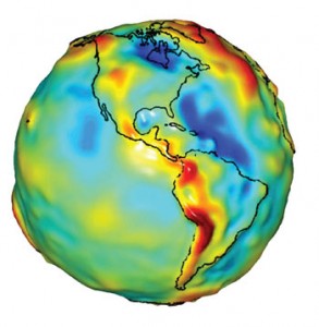
NASARepresentation of the Earth expresses the force of gravity, which is more intense in the areas in redNASA
In the sea and on land
Fernando Paolo, who is now doing a PhD at the Scripps Institute of Oceanography in the United States, prepared this map in 2010, while Molina, his supervisor, prepared the bigger one. The two images result from two sources of information, one local and the other global. The first are the apparati that measure the variation of the field of gravity, gravimeters, which are placed on buoys dragged behind 300 ships that have sailed along the coasts of Africa and Brazil for the last 30 years. The others are sea level variation meters installed in two satellites, the Geosat, which the United States Navy launched in 1986, and the European Remote Sensing Satellite (ERS-1), which has been in orbit since 1995. Molina says, “Using the two sources of information, we developed a methodology that allows us to see what the Brazilian continental platform is like in some areas better than the researchers who study this same region using just satellite data.”
Measurement of variations in the sea level by means of satellite, perhaps strange for novice sailors to consider, may indicate valleys or hills on the ocean’s surface that go undetected by other methods because not everywhere that the satellite examines has been evaluated by the various expensive and laborious bathymetric surveys. On land, this type of leveling, which uses GPS (global positioning system) devices and demands a good knowledge of the field of gravity, substitutes relief measurements by classic geometric leveling, which is obtained using a theodolite. Each measurement indicates relief variations at distances of approximately every 100 meters and covers just a few kilometers per day.
“Every work of engineering needs accurate altitude data,” says Denizar Blitzkow, a professor at USP’s Polytechnic. The apparatuses with which he began to measure gravity variations in São Paulo in the 1970s are soon to be displayed at the Museum of Civil Engineering, which should open later this year.
This way of measuring variations associated with the field of gravity, when added to other techniques, has indicated oil deposits in regions of the northeast of Brazil, for example. Measurement of the variation in mass – and of the force and acceleration of gravity, which are directly proportional to this mass – can also indicate where there may be unexplored ore deposits or caves. This technique clarifies the previously inexplicable details of geological maps, reveals differences in the thickness of the lithosphere (the Earth’s crust), and shows how and where the amount of water in the underground deposits of the major aquifers may vary throughout the year. “Until a few years ago,” says Molina, who began working with gravimetry in the early 1980s, “all this was impossible.”
Information coming from the two new European satellites Grace and Goce has been providing details of the variations in the field of gravity since 2003, as well as allowing for a more exact, albeit somewhat uncomfortable, picture to be built of the shape of the Earth. The Greeks imagined the Earth to be a perfect sphere, but this perfection crumbled when the possibility that the planet turned continuously was consolidated during the Renaissance. Newton stated that as a consequence of its rotation, the Earth must be flat/oval.

EDER C. MOLINA / IAG-USPVariations of up to 70 meters in the mean level of the sea reflect differences in the Earth’s field of gravity EDER C. MOLINA / IAG-USP
Seen from space, the planet still seems to be an almost perfect sphere, though maps based on the acceleration of gravity represent a deformed Earth, sometimes assuming a shape reminiscent of a heart. “The satellites are showing that we were wrong. Using the most recent measurements we saw that the Earth is not very flat,” says Blitzkow. The measurement of the axis of the Earth at the equator has shrunk by 250 meters, from 6,370,388 meters in 1924 to the current 6,370,136.5 meters.
Since 1982, Blitzkow has been working with teams from the IBGE on maps of variation in the field of gravity throughout Brazil. The most recent version, which includes other South American countries, came out in 2010. It shows that the force or acceleration of gravity is smaller in an area that includes Ceará, some of the neighboring states and the central region of the country, and as far down as the area north of the State of São Paulo.
Andes and the Amazon
A few days before Christmas 2010 and one week prior to the deadline, Gabriel do Nascimento Guimarães presented Blitzkow with the fourth version of a more detailed map. This one included variations of the field of gravity in the State of São Paulo – the result of 9000 measurements points on land, complemented by information from the Grace and Goce satellites. This study forms part of the PhD thesis of Guimarães and of a larger project coordinated by João Francisco Galera Mônico, from Paulista State University (Unesp) in Presidente Prudente, for use in so-called precision agriculture, which looks for the best cultivation and harvesting conditions.
Geodesic maps made from differences in elements of the field of gravity smooth out the differences in relief. On the map of the geoidal height of the State of São Paulo, the relief varies by just six meters in height between east and west, with no sign of the mountains that are 1,200 meters high, close to the coast. On the map of South America, the highest regions are in the Andes, but just 40 meters above level zero, which corresponds to the height of the Amazon.
| The project |
| Gnss: Investigations and applications in geodesic positioning in studies related to the atmosphere and in precision agriculture – nº 2006/04008-2 |
| Type |
| Thematic Project |
| Coordinator |
| João Francisco Galera Mônico – Unesp |
| Investment |
| R$ 1,279,880.42 (FAPESP) |
The concept that the acceleration of gravity reflects the distribution of mass helps when it comes to understanding these now small differences. “The Andes, although 6,000 meters high, do not have much more mass than the Amazon,” says Blitzkow. “If we could weigh a cylinder of the surface of a mountain in the Andes and another from the Amazon, we would see that the difference in weight is not as great as the variation in altitude.” On the map of the geoidal heights of the Earth, the Himalayas chain is no more than a low hill.
Constructed by Germans and North Americans, Grace, an acronym of Gravity Recovery and Climatic Experiment, is a set of twin satellites. They are 200 km apart and were placed in space in 2002. Because they are in a low orbit, just 250 km up (other satellites with similar functions have been at least 1,000 km high), they measure the most subtle interferences in the Earth’s mountains and valleys on each of their trajectories: on-board equipment records variations of thousandths of a millimeter in the distance between them. Goce, an acronym for Gravity Field and Steady-state Ocean Circulation Explorer, was built by the European Community and launched in 2009 to record something complementary: the variation in the various elements of the field of gravity relative to three pre-established axes.
The acceleration of gravity is constantly gaining new applications. The origin of gravity, unlike that of other forces like electricity and magnetism, is still a mystery. No one knows how the Sun attracts the Earth and to a lesser degree, how the Earth attracts the Sun.
Scientific article
PAOLO, F. S.; MOLINA, E. C. Integrated marine gravity field on the Brazilian coast from altimeter-derived sea surface gradient and shipborne gravity. Journal of Geodynamics. v. 50, p. 347-54. 2010.