
University of Ferrara
University of Ferrara…University of FerraraExtensive use of digital technologies is providing scientists with new perspectives for archeological research. In November 2016, a laser scanning technique enabled researchers to obtain a high-resolution three-dimensional model of one of the blast furnaces at the São João de Ipanema Royal Ironworks, built in Iperó in inland São Paulo State beginning in 1810. The technology has also been used to support research on the activities of primitive peoples at three archeological sites in the state. The Interdisciplinary Center in Interactive Technologies (CITI-USP), headed by engineer Marcelo Zuffo, is a Brazilian hub for cyberarcheology—the intersection between computing and archeology—that provides research support to the Polytechnic School at the University of São Paulo (Poli-USP). “Cyberarcheology has seen increasing use around the world since the beginning of this century to reconstruct monuments for the purpose of science communication. However, the application of digital technology to do analytical computation in support of archeological research is still quite rare,” explains Professor Astolfo Araújo of the Museum of Archeology and Ethnology at USP (MAE-USP).
The project is a partnership between Citi and the MAE that seeks to establish the use of digital technologies as support tools for archeological research. The project also involves a third partner, the Duke Immersive Virtual Environment (DiVE) at Duke University in the United States, one of the world’s premier virtual reality technology centers. According to Zuffo, the partnership has enabled his team to understand the archeologists’ demands and steer the use of computational tools in that direction.
The Ipanema Ironworks was one of the first places where digital scanning techniques were used. The ancient industrial park already has a rich collection of iconography on the evolution of its structure and of the production processes during its two phases of operation. The first phase lasted until 1895, and the second began when the mill was reactivated during World War I (1914-1919). This material has been studied since 2009 by archeometallurgy researchers from the Department of Metallurgical and Materials Engineering at Poli-USP, under the leadership of Fernando Landgraf, who is also CEO of the São Paulo Institute for Technological Research (IPT). Landgraf says that laser scanning has yielded entirely new information about the internal structure of the blast furnace and its operating principle. The furnace is the reactor in which iron ore is turned into metallic iron. The configuration of the internal structure, called the internal void, is one of the principal factors in the operational quality of the furnace.
Ipanema has three blast furnaces, each more than 8 meters high (see Pesquisa FAPESP Issues nº 173 and 202). Two of the furnaces, the North and the South, are part of the original factory project and were scanned in 2015 by researchers from the University of Ferrara, in Italy. In 2016, the Citi team used drones to scan the entire exterior of the furnaces and the interior of the third blast furnace, which was built later and known as the Mursa furnace. “The scan showed that the internal profile of the North and South blast furnaces was altered frequently, in each case to increase productivity. The Mursa furnace, built between 1878 and 1885, was never put into operation and practically didn’t change at all,” Landgraf says.
He notes that analysis of the collected material showed that the blast furnace profiles from the Ipanema ironworks were compatible with the best metallurgical techniques used around the world and that, generally speaking, the internal profiles of blast furnaces still follow that design today. The research indicated that the technical know-how of the German and Brazilian engineers who built and operated the ironworks was much greater than the researchers initially thought. “The production quality was equal to or better than that seen in Europe during the same period,” Landgraf says, although production never reached the initial goal of 600 metric tons per year.

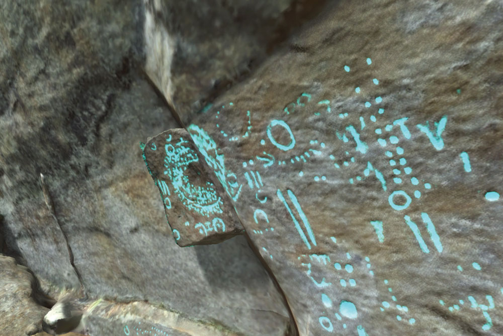
Eduardo Cesar
…and the output of the laser scanning model created by researchers from the University of Ferrara, showing the internal structure of the blast furnaceEduardo CesarThe Laboratory of Topography and Geodesy at Poli-USP and the Citi team worked together to scan another historic structure in 2016 using drones—the National Monument of the Ruins of the São Jorge dos Erasmos Sugar Mill, built in 1534 on the border between the cities of Santos and São Vicente, on the coast of São Paulo State. In this case, the 3-D reconstruction of the structure had the educational purpose of enabling interested parties to pay a virtual visit to the mill.
Lasers and high definition
These activities at the Ipanema ironworks and the Erasmos sugar mill are the outgrowths of a project launched in 2014 under the FAPESP Research Program on eScience, which seeks to integrate computer modeling, data infrastructure and research into other areas of knowledge. For field research at archeological sites, the Citi team opted for a combination of three high-definition 3-D scanning techniques. The first uses a Light Detection and Ranging (LiDAR) scanner, an optical technology that uses laser scanning to measure properties of reflected light to obtain information about distant objects. The second technique uses photographs and 360° high-definition videos, and the third is stereophotogrammetry, a process for three-dimensional reconstruction based on images captured in photographs or on film. The computer performs visual processing of several sequential images and viewing angles of an object of interest. By locating points in common in two or more images, it is possible to use triangulation to establish the spatial position of each point detected.
“The combination of these techniques makes it possible to digitally reconstruct the object being studied, at submillimeter resolution,” Marcelo Zuffo explains. One important feature is the ability to detect elements that are invisible to the naked eye. Another advantage is the reduced impact of the investigation. Conventional archeological methods, especially when they involve excavation, jeopardize the environment under study, no matter how careful the researchers may be. A preliminary site analysis from information gathered through the use of digital resources can make the exploratory process more objective, and therefore less destructive.
The technology can also be a useful tool for spatial reconstruction of objects removed from the site for laboratory analysis. “It’s practically impossible to establish the exact original layout of innumerable artifacts on the basis of memory and notes. Computer processing provides the ability to assemble the jigsaw puzzle and facilitates new interpretations of the collected materials,” Araújo says.

Poli/USP
3-D digital reconstruction of part of the Itapeva Rockshelter, done with images taken by dronesPoli/USPUnique spiral
To date, the joint research conducted by the MAE and Citi has occurred at three archeological sites: the Itapeva Rockshelter and the Santa Rockshelter, both in the municipality of Itapeva in São Paulo State; and at the Bastos site in Dourado, São Paulo, where remnants of the oldest human occupation in the state have been found and dated back to 12,600 years ago—the latter described in a recently published scientific study (see article).
The Itapeva Rockshelter is a site discovered in 1887 and excavated in the 1970s. Rock art estimated to be 4,000 years old has been identified there, in addition to engravings and artifacts that have an approximate age of 800 years. Archeologists believe that the engravings and artifacts are associated with indigenous peoples of the Jê linguistic group, and the paintings with earlier groups of hunter-gatherers.
In 2016, the processing of data captured with digital sensors enabled researchers to detect a spiral-shaped inscription that was invisible to the naked eye and had never before been identified at the Itapeva site. In October of that year, they made a field trip and confirmed the discovery.
The research at the Itapeva Rockshelter is being conducted in an inhospitable, hard-to-reach environment. Much of the evidence of rock art is found on a steep wall estimated at 20 to 30 meters high, parts of which are at times inaccessible. The Citi team used drones to capture 423-megapixel high-definition images and 4K video (four times the definition of present-day digital TV transmission). The site was also scanned with the LiDAR sensor and high-definition stereophotogrammetry.
Over the past two years, the Citi team has focused on developing a virtual tool that offers immersive, interactive visualization, enabling users to navigate and explore the digital databases of the Itapeva Rockshelter using virtual reality headsets that give them the sense of being at the exploration site. The tool, called Archeo VR, is in its third version, which includes resources for note-taking and local processing of 3-D and 2-D images. A 10-Gigabit (Gbps) connection between the USP and Duke virtual reality laboratories was set up in December 2016 to provide support for the tool, which can be accessed remotely for an interactive, collaborative experience.
Poli/USP
Engravings made by ancient peoples are enhanced using digital technologyPoli/USP“It’s a unique collaborative tool that will enable specialists and archeologists the world over to contribute to site analysis and archeological discoveries,” says Regis Kopper, a Brazilian computer scientist who heads the DiVE at Duke University. Araújo also points out that the tool can be useful in the classroom to promote greater student interaction with the material under study.
Preserving time
The Itapeva Rockshelter is located on an escarpment called Itanguá Canyon, where other, still-unidentified sites are believed to exist. In November 2016, the Citi team scanned an area of approximately 4 km2 with a drone, using stereovideogrammetry. The data they collected are still being analyzed.
Cyberarcheology can also be used to preserve information for future generations at archeological sites that are threatened by exposure to inclement weather conditions or human activity. Rock art has also been detected at the Santa Rockshelter, in the immediate vicinity of the Itapeva Rockshelter. The site, however, is deteriorating. In November 2016, the Citi and MAE teams went into the field for data acquisition using sensitive, ultra-high-resolution sensors in a 43.4-megapixel camera, to create a digital reconstruction of the environment while still preserving it.
“Archeologists hypothesize that the human occupants of the Santa Rockshelter had the same cultural component as the inhabitants of the Itapeva Rockshelter. The possible answers lie in geographic proximity and the similarity of the rock inscriptions. We will attempt to prove that hypothesis through 3-D processing of the data we capture,” says Marcelo Zuffo.
Project
CyberArchaeology: virtual reality and e-Science meets archeaology (nº 14/08418-7); Grant Mechanism Regular Research Grant; Program eScience; Principal Investigator Marcelo Zuffo (USP); Investment R$93,920.12.