LARP-MAE / USP3D map of the city of Rome in 360 A.D.: roads and monuments LARP-MAE / USP
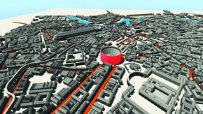
The teaching of history will become more comprehensive and interactive when computer applications such as Rome 360 begin to appear in classrooms. Rome 360 is an application that uses 3-D technology to map the Italian city in 360 A.D. Developed by the Laboratory for Roman Provincial Archaeology (LARP) of the Museum of Archaeology and Ethnology (MAE) at the University of São Paulo (USP), the software displays on-screen information about streets, temples and monuments like the Coliseum, the Circus Maximus, a site that held chariot races, the Basilica of Constantine and the temples of Venus and Jupiter, in addition to public pools known as Roman baths. The map was developed on the basis of the 1923 Historical Atlas by American William Shepherd. “From the outset of this project, we’ve thought about producing teaching material that could be used from the early years of elementary school through university,” says Alex Martire, a doctoral fellowship from FAPESP in cyberarchealogy, a field that uses virtual reality in the study of archeology. Access to the software application is available at the LARP site (www.larp.mae.usp.br). Led by Professor Maria Isabel Fleming, the group has completed another electronic model that now shows the interior of an old Roman house, called a domus.
Republish