SAMUEL VASCONCELOSEmbrapa’s unmanned aerial vehicle: the search for areas damaged by pests and crop failuresSAMUEL VASCONCELOS
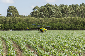
Embrapa Instrumentação, the instrumentation division of the Brazilian Agricultural Research Corporation, in São Carlos, in the state of São Paulo, has developed and improved processing software for use with images taken by unmanned aerial vehicles, UAVs, also known as drones. “By means of specific colors, analysis of the images performed by the software indicates crop failures, areas attacked by pests, water shortages, soil and other problems that damage agricultural crops,” says researcher Lúcio André de Jorge Castro, of Embrapa Instrumentação, responsible for developing the processing programs. The interpretation of the images will allow farmers to predict problems and make decisions. Currently, the technology is being validated for crops such as sugarcane, citrus fruits, corn and cotton, and on properties of varying sizes. The price of the drones is expected to range from R$1,000 to R$20,000.
Republish