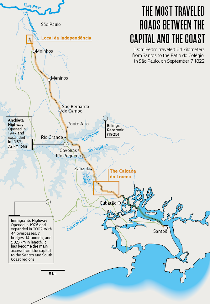
On September 7, 1822, before climbing into the Serra do Mar coastal mountain range to arrive in the city of São Paulo, then a city of 10,000 inhabitants, the prince regent of Brazil, Pedro de Alcântara (1798–1834), took a boat from Santos to Cubatão. Contrary to what has been stated in some history books, Dom Pedro, the son of the King of Portugal, Dom João VI (1767–1826), couldn’t have made that portion of his journey on horseback, because there was no overland passage between the island of Santos and the mainland at the time.
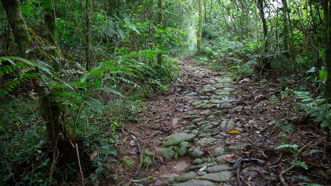
And, when they climbed through the mountains along the winding, cobblestone path known as the Calçada do Lorena and the prince regent shouted his famous cry “Independence or death!”, he and his 36 companions were probably riding on mules, not on dashing horses like those portrayed in the renowned painting by the artist Pedro Amerigo (1843–1905). The mules were the safest way to climb the Serra do Mar and there are no records that they changed animals, according to recent studies by researchers at the Paulista Museum (MP).
 Source Jorge Pimentel Cintra/MP-USP | Infographic Alexandre Affonso
Another conclusion from their research: the exact site of the prince’s declaration of independence is actually 200 meters north of where the historic landmark, a cobblestone-shaped rock, was placed in 1825, 600 meters from Ipiranga Creek, a nine-kilometer-long stream which has since been partially channeled. The misplaced landmark was lost over time and only recovered again in 1922, during the renovation of the Parque da Independência, but it was never replaced.
“We’re fixing quite a few details around the history of our independence,” says Jorge Pimentel Cintra, an engineer from the Polytechnic School and the MP, both at the University of São Paulo (USP). A specialist in historical cartography, in 2013 he recreated the map of the Hereditary Captaincies and presented it in the journal Anais do Museu Paulista. Over the last three years, he has consulted reports and graphic representations, climbed up and down the Serra do Mar several times, and spoken at length with fellow historians.

José Rosael / Hélio Nobre / MP-USP / Wikimedia CommonsCalçada de Lorena, 1826 watercolor by Oscar Pereira da SilvaJosé Rosael / Hélio Nobre / MP-USP / Wikimedia Commons
As a result, he redrew the map of the 64-kilometer journey Dom Pedro traveled on that decisive day from Santos to the Pátio do Colégio, then the seat of São Paulo government. It was there that the future first emperor of Brazil ended his long day’s work. That evening he went to the Opera House sporting a hastily made gold armband that read “Independência ou morte” (Independence or death). One of the MP’s exhibits, set to open on September 7, will show a 10-minute video that takes viewers on a flight over the famous journey made between Santos and the Pátio do Colégio on Independence Day.
One of the maps the museum team has developed will present the Calçada do Lorena, the first paved access between the capital city and the port of Santos, which was primarily used to transport sugar production from the interior of São Paulo State. “Until now, there was no detailed map,” says Cintra, who traveled the path marking the coordinates with a GPS device (see table and map).
 Source Jorge Pimentel Cintra/MP-USP | Infographic Alexandre Affonso
From the Imperial Palace to the Pátio do Colégio
The journey that culminated in the Proclamation of Independence had begun almost a month earlier. On the morning of August 14, 1822, determined to form alliances with landowners, defuse threatened uprisings, and prepare the ground for political separation from Portugal, the prince and his entourage left the Imperial Palace—now known as the Palácio de São Cristóvão—in Rio de Janeiro. He traveled through the villages of the Paraíba Valley, then a thriving coffee-growing region, and, after riding about 500 kilometers on horseback, arrived in São Paulo on August 25 (see map).
Ten days later, after talking to politicians, kissing hands, and waving to his people, Dom Pedro resumed his planned route and, now traveling by mule, headed for the coast, descending the Calçada do Lorena to arrive at the village of Santos. He spent the 6th of September there, visiting fortresses and the family of his minister José Bonifácio de Andrada e Silva (1763–1838). The Minas Gerais historian Eduardo Canabrava Barreiros (1908–1981) details this part of the journey in his book Itinerário da Independência (José Olympio, 1972).
“Barreiros says that Dom Pedro and his entourage passed over an embankment and crossed rivers to go from Cubatão to Santos, but it’s not possible, because this route was only built five years later,” comments Cintra, after examining the reports and maps in Barreiros’s book. His conclusion is that the travelers must have gone by ferry or fishing boat, like those portrayed in Santos at the time by the British painter and naturalist William Burchell (1781–1863). “The route by boat passes through the Caneu estuary, in Santos, and continues along the Cubatão River to the landing port,” he says. Historian and MP curator Paulo César Garcez Marins, who did not participate in the research, adds, “The correction Cintra has proposed is absolutely necessary, because what was being claimed didn’t exist in 1822.”
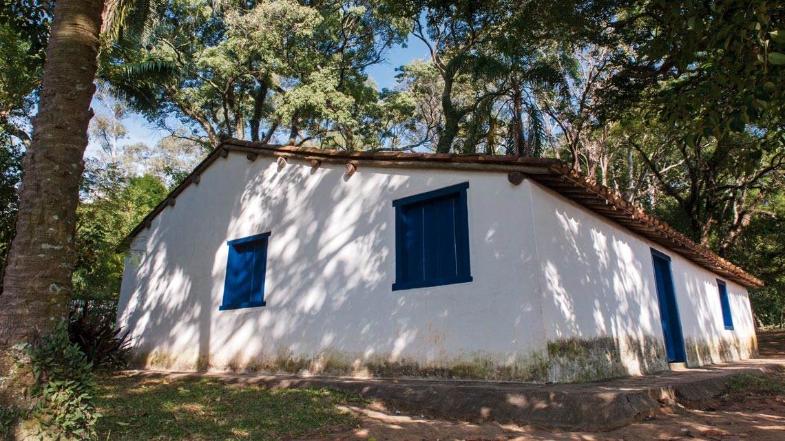
Léo Ramos Chaves / Revista Pesquisa FAPESPCasa do Grito, in the Parque da Independência, built in 1844Léo Ramos Chaves / Revista Pesquisa FAPESP
Before dawn on September 7, a Saturday, Dom Pedro and his group returned to the capital city of the Captaincy of São Paulo by ascending the Calçada do Lorena, which the museum team has now studied thoroughly. The trail’s name is a tribute to the governor of the Captaincy of São Paulo, Bernardo José Maria de Lorena (1756–1818) of Portugal, who promoted its construction.
Quite steep, with about 700 meters of elevation change from beginning to end, the route winds a zigzagging path with 133 turns, varying in width from 3.2 meters to 4.5 meters along approximately nine kilometers of dense jungle, under almost constant rain, without crossing any watercourse.
The Calçada was planned by military engineers, then built with slave labor, and remained in operation from 1790 to 1846, replacing “paths that were little more than primitive indigenous trails,” pointed out architect and USP professor Benedito Lima de Toledo (1934–2019) in an article published in December 2000 in the journal PosFAUUSP.
“What surprised people the most was the technique used to surface it: paving with stone slabs,” Toledo wrote. The new paving technique provided for “its continual transit by troops of mules that, at that time, were beginning to be widely used in cargo transport.” Before, everything destined for the port of Santos was “carried on the shoulder of an indigene.”
 Source Jorge Pimentel Cintra/MP-USP | Infographic Alexandre Affonso
Eventually overtaken by jungle, the Calçada was restored in the early 1990s by Eletropaulo, (a now defunct, state-owned electricity company), later managed by the state’s environmental agency Fundação Florestal, and recently consigned for private-sector commercialization in 2020. It was opened to visitors the following year and currently receives 3,000 to 5,000 people per month, according to biologist Maycon de Oliveira Morais, from the company Parquetur. “We’ve learned a lot from the museum staff,” he says.
Cintra and his team mapped the first stretch, about four kilometers long, which is now open to visitors, and a second stretch, measuring two kilometers that’s still closed to tourists. The remaining section, from 150 meters elevation down to sea level, was subsumed by the Presidente Bernardes refinery, which was inaugurated in 1955. The researchers were unable to gain access to examine this part of the Calçada.
“Up on the plateau, the Calçada originally passed in front of the Nossa Senhora da Boa Viagem chapel, in the center of São Bernardo do Campo,” the researcher observes. He retraced the route using a map from the São Paulo Geographic and Geological Commission from the year 1900, and another from 1832, drawn up by order of Rafael Tobias de Aguiar (1794–1857), then president of the province. The prince regent also passed in front of what is now the Mauá Institute of Technology and twice crossed over the Meninos River before reaching Ipiranga, then an open field. Today, no physical record remains of the Calçada in these locations.
At around 4:30 p.m. on September 7, Dom Pedro and his entourage were on a hill next to Ipiranga Creek when they were met by two messengers. They were delivering four separate letters to the prince sent by his wife Leopoldina (Leopoldina Carolina Josefa de Habsburgo-Lorena, 1797–1826), José Bonifácio, King Dom João VI, and his friend Henry Chamberlain (1796–1844), describing the conflicts with Portugal and urging him to politically separate from the mother country. Conversely, instructions from the Portuguese Cortes (constitutional assemblies) were demanding the prince’s immediate return and the arrest of José Bonifácio. There are two accounts of what happened next.
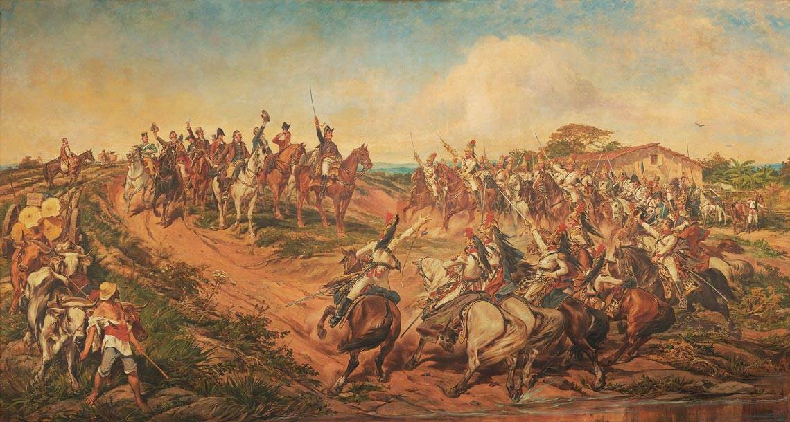
Wikimedia CommonsIndependência ou morte (Independence or death), oil on canvas painted in 1888 by Pedro AméricoWikimedia Commons
The first is recorded in the book D. Pedro I e o grito da Independência (Dom Pedro I and the cry of independence) (Melhoramentos, 1921), by historian Francisco de Assis Cintra (1887–1947). The historian records the following report by one of the prince’s companions, Father Belchior Pinheiro de Oliveira (1775–1856): “Dom Pedro, trembling with rage, snatched the papers from my hands and, crumpling them, trampled them, left them on the grass. I quickly picked them up and saved them. Then he turned to me and said: ‘What now, Father Belchior?’ And I promptly replied: ‘If Your Highness does not make yourself king of Brazil, you will be a prisoner of the courts and, perhaps, disinherited by them. There is no other way but independence and separation.’”
The prince further added, as he walked, “The courts persecute me, they contemptuously call me a boy and a Brazilian. Well, now they’ll see what this little boy is worth. From now on our relations are broken; I want nothing more to do with the Portuguese government and I proclaim Brazil, forever, separated from Portugal.” And finally, he turned to his aide-de-camp: “Tell my guard that I’ve just declared Brazil’s independence. We are separated from Portugal.” Then he proclaimed independence again, in front of his honor guard.
The second account is told by the commander of that honor guard, Manuel Marcondes de Oliveira e Melo, baron of Pindamonhangaba (1780–1863). As presented in the Historia do Brasil-Reino e Brasil-Imperio (Pinheiro, 1871), by the historian Alexandre Jose de Mello (1816–1882), it is somewhat more theatrical. “In front of the guard, which formed a semicircle, [the prince regent] stopped his animal and, with his sword drawn, shouted: ‘Friends! The ties that bound us to the Portuguese government are forever broken! And as for the scoundrels of that nation, I invite them to do likewise.’ And taking the blue and white ribbon from his hat, he threw it on the ground, and was followed in this by the entire guard who, taking the same badge from their arms, did the same. … ‘And long live free and independent Brazil!’ cried Dom Pedro. To which, drawing our own swords, we replied, ‘Long live free and independent Brazil! Long live Dom Pedro, its perpetual defender!’ … And the prince shouted on: ‘Our motto from now on shall be: Independence or death!’. … For our part, and with the liveliest enthusiasm, we repeated: ‘Independence or death!’”
To discover exactly where all this took place, Cintra examined paintings, photos, accounts, and old maps. He found inconsistencies, went to the field with a tape measure, compass, and GPS and measured the distance between Ipiranga Creek, with its banks now concreted over, and a bridge, which is no longer there. “In 1822, the bridge was located a little to the right of the current green metallic footbridge, closer to Rua Leais Paulistanos, and a little to the south of the current watercourse, which was moved during construction of the Monument to Independence,” he wrote in a December 2021 article in the Anais do Museu Paulista.
Stay, that’s what everyone asks of our magnanimous prince, who is Your Highness, for the pride and happiness of Brazil.
And if you don’t stay, rivers of blood will flow in this great and noble land, so dear to your royal father, who no longer rules in Portugal, due to the oppression of the Cortes; [stay] in this land that esteems Your Highness so highly and which Your Highness esteems so highly.”
Excerpt from José Bonifacio’s letter
In 1825, as a result of a São Paulo City Council meeting that was held on-site, with assistance from surveyors and people to witness the proclamation, a landmark was placed 405 meters from the bridge. For some unknown reason, 40 days later, without considering the location of the original landmark—which had probably been removed—a new landmark was implanted, a stone placed 200 meters from the point determined by the initial measurement.
Cintra concluded that this spot was wrong, as it was a relatively flat area, which differs from reports that the prince regent had been halfway up a hill. “The stone was buried and lost a short time later, found in 1875 and again buried and lost, but the location was kept as if it were correct,” comments the MP researcher.
In 1902, German doctor and ornithologist Hermann Von Ihering (1850–1930), the museum’s first director, took his doubts about the exact location to a debate with colleagues from the Historical and Geographical Institute of São Paulo (IHGSP). As a result, a commission coordinated by engineer Antonio de Toledo Piza e Almeida (1848–1905), one of the institute’s founders, confirmed the previous measurement was in error, made new measurements, and installed a flagpole in the correct location 405 meters from the old Ipiranga bridge, next to another stone.
Removed in 1922 during a renovation of the Parque da Independência, they were never replaced—the landmark is now in the museum’s collection. “Since 1922 nothing else has been done,” comments Cintra, “so the most precise site of the ‘Cry of Independence’ remains ignored and undistinguished.
Upon reaching the plateau, the future emperor and his entourage were in all likelihood riding the much safer and tougher mules, rather than horses, which were used primarily for speed on flat terrain. Why then, did Pedro Américo portray them mounted on horses in the famous painting Independência ou Morte? Also known as The Cry of Ipiranga, the work is to this day considered the most important piece in the Paulista Museum.
“The conventions of European history painting determined that the mounts in heroic or battle scenes had to be horses,” Marins argues. “That was the proper way to represent the past. Painting mules would have shown a lack of decorum.”
Américo painted the work on commission from the imperial government, inspired by the French artist Ernest Meissonier (1815–1891), who had painted the Battle of Friedland (1875). He exhibited the work for the first time in Florence, Italy, in 1888, in a ceremony attended by the Emperor of Brazil Dom Pedro II (1825–1891) and the British Queen Victoria (1819–1901). Measuring 4.15 by 7.60 meters, the work was exhibited at the inauguration of the Paulista Museum, on September 7, 1895, and has remained in its great hall ever since.
Américo was not the only artist to embellish the scene. In addition to showing the prince and his guard on horses, the French painter François-René Moreaux (1807–1860) included children, and men and women embracing each other in his painting The Proclamation of Independence, from 1844. Commissioned at the request of the Senate, the work, measuring 2.44 by 3.83 meters, hangs in the Imperial Museum of Petrópolis, in Rio de Janeiro. “Historical paintings are not reality, they are interpretations of the past,” emphasizes Marins.
Scientific articles
CINTRA, J. P. Reconstruindo o mapa das Capitanias Hereditárias. Anais do Museu Paulista. v. 21, n. 3, p. 11–45. dec. 1, 2013.
TOLEDO, B. L. de. Do litoral ao planalto – A conquista da serra do Mar. PosFAUUSP. v. 8, p. 150–67. dec. 19, 2000.
CINTRA, J. P & CINTRA, A. P. O sítio da Independência no Ipiranga: As vicissitudes de um local histórico. Anais do Museu Paulista. v. 29, p. 1–48. dec. 10, 2021.
Books
BARREIROS, E. C. Itinerário da Independência. Rio de Janeiro: José Olympio, 1972.
CINTRA, A. D. Pedro I e o grito da Independência; transcrição de documentos. São Paulo: Melhoramentos, 1921.
MORAES, A. J. de M. Historia do Brasil-Reino e Brasil-Imperio. Rio de Janeiro: Typographia de Pinheiro, 1871.