 FABIO COLOMBININow that environmental issues have become the focus of the world’s attention and forests are being destroyed to make way for plantations and cities, some good news has been reported on the regional stage. The areas covered by native vegetation in the State of São Paulo have increased for the second consecutive decade and, even though this area is broken down into hundreds of thousands of fragments smaller than a soccer field, the total size is similar to that of the early 1970’s.
At present, 4.34 million hectares of fields and forests in different states of conservation – especially the Mata Atlântica Rain Forest – cover an area equal to 17.5% of the state’s territory. This data comes from the latest survey on the original native vegetation in the state, conducted by the São Paulo Forestry Institute and announced on March 17. This data is summarized in the map included in this issue of Pesquisa FAPESP. This area is seemingly the same size as the 4.39 million hectares that native forests covered 40 years ago, before pastures and sugarcane plantations permanently transformed the varied and exuberant landscape of the native forests into monotonous green fields.
The 4.34 million hectares of native vegetation documented in Inventario florestal da cobertura vegetal native do estado de São Paulo (period de 2008 e 2009) [a forest inventory for the State of São Paulo for the period 2008/2009], equal an area 25% bigger than the area surveyed at the start of this decade – in 2001, the previous version of this survey, also described in Pesquisa FAPESP , had identified 3.46 million hectares encompassing the Mata Atlântica rain forest, the Cerrado savanna eco-region, and mangroves. Although this area includes not only recovered forests but also other vegetation, the increase in native vegetation and fields has consolidated a trend detected in the state in the last 20 years, when possibly for the first time since Brazil was colonized by European settlers, São Paulo State’s native vegetation has stopped disappearing and begun to expand.
The increase in the vegetation mapped by this survey has led many environmentalists and conservationists to become more optimistic. On the day when the survey results were announced at the head office of the Instituto Florestal, in a corner of the Mata Atlântica rain forest, to the north of the state’s capital city, Xico Graziano, the São Paulo State Secretary of the Environment, stated that: “Deforesting has diminished and the recovery of forests has increased. We have managed to turn the page.”
The fact that the native vegetation has increased is good news, but it should be interpreted cautiously. The new survey resulted in an additional 886.4 thousand hectares in comparison to the results obtained in the previous survey. This area is not all covered by fields and forests recovered in the period. Much of this apparent growth – more specifically, 345.7 thousand hectares – is due to the use of higher-resolution satellite images than the ones used in the previous survey. By revealing more details, these images allowed the sizes of the known fragments to be redefined, and in many cases, these fragments were bigger than previously estimated.
This year’s version of the inventory, the fifth such survey prepared by the Forestry Institute since 1962, is based on approximately 100 images of the state’s territory taken in 2008 and 2009 by the Japanese satellite Alos, on a scale of 1:25 000, in which each centimeter of the map represents 250 meters on land. This resolution is four times higher than that of the previous survey, based on images on a scale of 1:50 000 obtained by the Landsat and Cbers satellites. São Paulo is not the only state that keeps track of whatever native vegetation remains in order to establish more appropriate conservation policies. The states of Rio de Janeiro, Minas Gerais, Espírito Santo, Santa Catarina and Rio Grande do Sul have already conducted similar surveys, but none of these state-wide surveys has the level of detail of the São Paulo one. The survey cost R$1,5 million; 16 specialists worked for 15 months to interpret the images.
With fourfold resolution, the images produced by the Alos satellite showed much smaller areas than the ones seen previously. In the previous survey, the smallest identified forest fragments measured an average of three hectares, or 30 thousand square meters, the size of three soccer fields. In the current survey, the team led by researcher Marco Aurélio Nalon, a specialist in geoprocessing from the Forestry Institute, was able to detect blocks covered by natural vegetation measuring only 0.25 hectare or 2,500 square meters, equivalent to one-fourth the size of a soccer field.
 According to Nalon, the 1:50.000 scale was, for a very long time, sufficient for environmental licensing and monitoring bodies to track environmental degradation in the state and for researchers from such programs as Biota-FAPESP to conduct surveys on the state’s flora and fauna. However, the time had come to improve this. “As the pressure for land use has been increasing, we need to see everything in more detail,” says Nalon. Nalon has been working for nearly 20 years with agronomist Francisco Kronka, coordinator of the three last versions of the inventory and author of another paper published in this issue of Pesquisa FAPESP.
The images produced by Alos, which show the tops of the trees, allowed Nalon’s team to identify previously unknown 445.7 thousand hectares of forests, broken down into 184.5 thousand fragments spread throughout the state. The researchers do not yet know how many of these fragments are new, meaning recovered forests. It is very likely that many were existing fragments that had not been mapped previously because they were too small to be captured by the satellite cameras used earlier. “These 184.5 thousand fragments were concealed,” says Nalon. “Now they have an address and an identity.” Before, they could have been destroyed and the environmental authorities would not know about it. Now, this is no longer possible.
According to Nalon, approximately 95 thousand hectares correspond to newly recovered areas in the Cerrado (savanna) and Mata Atlântica forest ecosystems, which had been replanted or where vegetation grew again after the depleted land was abandoned. In short, these areas represent the actual growth of native vegetation in São Paulo in this decade. “From the early 1990s to 2001, the areas of greenery in the state increased by 120 thousand hectares,” says Nalon. “Therefore, an increase of 95 thousand hectares in the last few years is quite plausible.” This is an impressive number, as it is equivalent to 600 parks such as Ibirapuera, the best-known park in the capital city of São Paulo. This size is also equivalent to 23 forests such as the ones that comprise the Tijuca national park, in the city of Rio de Janeiro. It is as if 23 such forests, that comprise the biggest urban forest in the world, had sprung up in the state of São Paulo in less than 10 years.
This good piece of news, however, should not give rise to complacency. Even though more vegetation is being recovered in the state, this recovery is concentrated in regions in which the vegetation had already been growing. “In the past decade, we detected deforesting in the western part of the state, and perhaps it is still going on in that region,” says Nalon, who expects to have an answer soon in this respect. In the next few months, Nalon and his team plan to conclude the survey on the green area in each municipal region of the state and send the data to 645 mayors. This information will be permanently available on the site of the Sistema de Informações Florestais do Estado de São Paulo, the state forest information system (www.iflorestal.sp.gov.br/sifesp/). With this data available, government officials will be able to track compliance with environmental laws and researchers will be able to identify the habitats of specific plant and animal species more accurately.
Where the forests are located
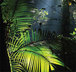
As shown on the map, much of the native vegetation is found on the coast, a strip less than 100 kilometers wide, delimited by the Serra do Mar mountain range and the beaches. The municipal regions of Caraguatatuba, Ubatuba, São Sebastião and Ilhabela, on the state’s northern coast , are still largely covered by native vegetation. On average, 88.6% of this region consists of rain forests and mangroves that are being slowly devastated by increasing property development. Although proportionally high, the actual size of this region is quite small: it measures only 168.9 thousand hectares. In absolute terms, the largest continuous extension of native vegetation is spread through the south coast of the state and through the valley of the Ribeira de Iguape River, close to the border with the state of Paraná. This region, the state’s poorest, is still covered by well-preserved 1.22 million hectares of the Mata Atlântica rain forest, which once comprised 65% of the state.
However, very little remains of the Cerrado savanna that once covered the gently rolling inner-state land. Whatever is left of it – and it is still being devastated – lies in the Ribeirão Preto, Franca, São José do Rio Preto, Bauru, Sorocaba and Campinas regions. In the last few decades, sugarcane plantations – the main drivers of the state’s economy – have substituted pasture land, coffee plantations and native forests.
Although the new survey has indicated considerable gains in terms of greenery – even if the increase provided by the higher resolution images had not been taken into account – some people feel that the news is not particularly encouraging. At least 12% of the state’s green areas (531 thousand hectares) are broken down into small fragments, some of which measure less than 10 hectares. In the opinion of several ecologists, these small areas do not allow for the survival of a wide diversity of plants and animals, and are therefore of little interest to environmental conservation.
 FABIO COLOMBINIThis proportion, however, is not that simple. One ecological school of thought – according to which each native ecosystem, no matter how small, is important – is gaining strength in the country. Each fragment can contain a unique genetic data base, able to contribute significantly to the conservation of biodiversity and to the recovery of similar ecosystems. “Even in highly degraded environments, measuring less than 10 hectares, these fragments play an important role in the conservation of the remaining biodiversity,” says Ricardo Ribeiro Rodrigues, coordinator of the ecology and forest recovery laboratory at the Luiz de Queiroz agricultural college in the city of Piracicaba. “In regions where agriculture predominates, with no major conservation areas in the vicinity, the forest fragments are the only source of information on what the native vegetation looked like and how it functioned; these fragments can become a rich source of data under suitable stewardship,” he explains.
These native vegetation fragments – especially the smaller ones – are seed and plant embryo banks that are still unknown to researchers. “Only 35% of forest remains are in conservation units, most of which are in areas bigger than 100 hectares, where scientific research is usually conducted,” says Rodrigues.
In view of this potential, the identification of 184.5 thousand new fragments, added to the 120 thousand known areas, sounds encouraging. “This means that the existing fragments are closer to each other than we had previously believed,” says Giselda Durigan, a researcher at the Forestry Institute in the city of Assis, and an expert on the conservation and recovery of ecosystems. “This proximity will certainly facilitate the recovery of forests.”
Giselda is coordinating a major study organized by the State Environmental Bureau. The objective of this research is to discover what leads a planted forest to flourish and become consolidated. The study focuses on four areas covered in native vegetation and 26 planted areas that have been growing for at least four years (the oldest of such areas is 55 years old) without being touched. She recently discovered that an essential element for the successful recovery of these forests is to have a good fragment of native vegetation located nearby.
For example, 29 species of trees were planted in the midst of a huge sugarcane field in the municipal region of Tarumã, close to Assis, in the western part of the state, to recover a fragment of the native vegetation. Ten years later, another 23 species had grown spontaneously, mostly brought by birds and other animals from neighboring fragments with native vegetation – the smallest of these measuring one hectare. Something similar happened at a farm in the southeast region of the State of São Paulo, where 165 species of native trees had been planted on 20 hectares in 1972. The latest survey of this area, conducted in 2009, showed that another 64 species have flourished there. “We still don’t know what is the ideal minimum distance for species to migrate from a fragment to a planted area,” says Giselda, “but the closer the fragment to the forest undergoing recovery, the faster the species will arrive. Furthermore, if the planted forest is an old one, then more species will migrate there.”
If this influence of the fragments proves to be consistent, the recovery of forests in the state may become simpler and less expensive. “One can create ecological corridors through the recovery of vegetation on riverbanks,” says Rodrigues. “If this vegetation recovers, we will be able to interconnect most of the fragments in the state of São Paulo.”
Republish