eduardo cesar
Mission of São Miguel, founded in 1632 in Rio Grande do Sul State: clues to the intensity of the magnetic field in the 17th centuryeduardo cesarPublished in June 2016
The fired clay floor in the ruins of the Seven Peoples of the Missions, in northeastern Rio Grande do Sul State, preserves more than just the memory of the traumatic evangelization of the Guarani Indians by Jesuit priests—a process that ended in a bloody war and expulsion of the Jesuits and their followers from the region in the mid-18th century. The clay also holds a precious record that is key to understanding how the Earth’s natural magnetic field has varied through the centuries.
While analyzing fragments of the floors of three Jesuit missions, geophysicists Wilbor Poletti, Gelvam Hartmann and Ricardo Trindade, all from the University of São Paulo (USP), discovered evidence of the intensity of the Earth’s magnetic field in southern Brazil in the second half of the 17th century. “These are the first data from the southern region for that period,” says Poletti, one of the study’s coauthors. “Earlier studies only analyzed samples from the Northeast and the Southeast.”
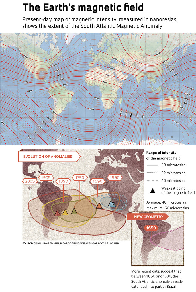
Combining the data from this and prior studies, Trindade’s team found that in the 17th century, the intensity of the magnetic field in southern Brazil was significantly lower than that in the north. This conclusion indicates that the South Atlantic Magnetic Anomaly (SAMA), an important phenomenon of the Earth’s magnetic activity, began to influence the intensity of the magnetic field in the South American continent about 200 years earlier than scientists had thought. “Contrary to what the current models suggest, the anomaly existed on the continent between 1650 and 1700,” Trindade says. “We need to incorporate these data and refine the models.”
According to the theory accepted by most geophysicists, the Earth’s magnetic field is generated by movement in the layer of liquid iron surrounding the planet’s solid iron core. Since the Earth’s core rotates faster than the surface, currents form in this ocean of liquid iron, producing a field of two opposing magnetic poles, more or less near the geographic North and South Poles. Although the field intensity on the planet’s surface is about 1,000 times weaker than a refrigerator magnet, it is strong enough to be detected by compasses that help navigators and explorers find their way around the globe. Higher up, at the top of the atmosphere, the magnetic field, which is even weaker, acts as a particle shield, deflecting a large percentage of the electrically-charged particles that would strike the planet’s surface towards the Earth’s magnetic poles.
The Earth’s magnetic field also exhibits other peculiarities besides the two poles. Some regions of the globe have weaker or stronger magnetic fields than one might expect if the field was a perfect dipole. The SAMA is the largest and most extreme of these imperfections.
The average intensity of the Earth’s magnetic field is 40 microteslas, but the average in the SAMA region is only 28 microteslas. The SAMA occupies much of the southern portion of the Atlantic Ocean, in addition to a vast area in central and southern South America. At the center of the anomaly, currently located in Paraguay, the field drops to 22 microteslas. This lower intensity affects the operations of communications satellites and even space telescope observations. NASA’s Hubble telescope does not work when it passes over the SAMA.
 Studying magnetic anomalies like this one, in detail, can help geophysicists better understand how variations in the movement of the liquid iron inside the planet alter its magnetic field over time. “The SAMA is a hotly debated topic because it may be the cause of the general weakening of the Earth’s magnetic field, which has been observed over the past few centuries,” Poletti explains. “The magnetic field today is 10% weaker than when it was first precisely measured in 1839 by Carl Friedrich Gauss.”
The SAMA previously occupied a smaller area in another location. In 2009, Hartmann and Igor Pacca, the latter of whom is a professor emeritus at USP and a pioneer of geomagnetism research in Brazil, used models based on historical records of the Earth’s magnetic field to reconstruct the evolution of the SAMA since 1590. Their findings indicate that at the end of the 16th century, the anomaly covered only a small portion of southern Africa and the Atlantic. Between then and now, it has expanded and moved to the west. Their reconstruction also shows that the anomaly only began to influence the magnetic field in Brazil in the early decades of the 19th century.
In 2011, Hartmann and Trindade published new data indicating that the SAMA had moved and expanded more quickly than the earlier model had suggested. Working with Brazilian archeologists and researchers from the Institute of Earth Physics of Paris (IPGP), the USP geophysicists reconstructed the history of the magnetic field over Brazil since the 16th century by analyzing fragments of bricks from old buildings in the states of Bahia, São Paulo, Rio de Janeiro and Espírito Santo (see Pesquisa FAPESP Issue nº 185). The data from Rio Grande do Sul recently obtained by Poletti, Hartmann and Trindade lend more substance to the earlier findings.
The group confirmed that prior to 1600, the Earth’s magnetic field was roughly the same strength throughout Brazil. Between the 17th and 18th centuries, however, it weakened slightly in the South and Southeast, probably because the SAMA was already covering those parts of the country. The magnetic field in all parts of Brazil again began to register more or less the same strength beginning in the 19th century, when most of the country was assumedly under the SAMA.
Seven peoples of the missions
Following a trip through the region of the Seven Peoples of the Missions, it was Pacca who suggested to Trindade, Hartmann and Poletti that they contact the National Institute for Historic and Artistic Heritage (Iphan) and speak to the people responsible for these historic buildings. Pacca realized that the ruins of these missions were of an ideal age and location for filling an important gap in the data on the SAMA.
The missions were large villages built by Guarani Indians who had been Christianized by priests of the Society of Jesus. They reached the pinnacle of their missions between the 17th and 18th centuries when the Jesuits, sponsored by the Portuguese and Spanish Crowns, maintained 30 missions in the Jesuit Republic of Guaranis—an area now located on the border between the regions of Brazil, Argentina and Paraguay. Each mission was governed by two priests and was home to 5,000 to 6,000 Indians. “The priests governed the people with religious discipline and the help of the tribal chiefs,” says Raquel Rech, an archeologist at Iphan who collaborated with Trindade’s team.

Wilbor Poletti / IAG-USP
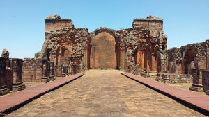
Ruins of the Mission of La Santísima Trinidad de Paraná, in Paraguay: a brick-paved courtyardWilbor Poletti / IAG-USPThe Jesuit order had already lost its influence with the Iberian Crowns when Spain and Portugal signed the Treaty of Madrid in 1750, which redefined the borders between their South American colonies. The seven missions, presently located in Brazil, were abandoned and destroyed during the Guarani War, which lasted from 1754 to 1756. For four of these missions—São Miguel, São Lourenço, São João Batista and São Nicolau—a few buildings remain standing. Of the missions of Santo Ângelo, São Luiz Gonzaga and São Borja, the only remaining ruins are found in the subsoil beneath modern cities, and some of that material has been recovered through archeological excavations.
All the missions had the same architectural plan, with a large unpaved central square, where the community conducted its daily activities. On one side of the square was the main complex of buildings, consisting of a church in the center, a cemetery on one side and a schoolyard and Indian workshop on the other. The walls of these buildings were made with blocks of slab rock cut and placed by the Indians, and the material is unsuitable for studying the magnetic field of the time when the missions were built. The rectory, however, had an internal courtyard with a flooring of clay bricks, fired in ovens at temperatures of around 1,000 degrees Celsius. Poletti explains that at temperatures above 580 degrees, the magnetic moments of the mineral magnetite, which is present in the clay, align themselves with the Earth’s magnetic field. The degree of alignment depends on the intensity of the magnetic field at the location where the clay was fired. When the material cools, the magnetic moments stabilize, preserving the intensity of the Earth’s magnetic field at that time.
Rech and the historian Nadir Damiani of the Integrated Regional University of the Upper Uruguay Valley and Missions helped the USP geophysicists collect the material they needed. The team chose fragments of bricks from the São Luiz Gonzaga, São João Batista and Santo Ângelo missions, built between 1657 and 1706. They also obtained fragments of fired clay tiles from the Santo Ângelo mission.
These measurements represent a new stage in archaeomagnetic research in Brazil. In 2011, Hartmann obtained the first Brazilian archaeomagnetic records while studying the material from historic buildings in São Paulo, Rio de Janeiro, Espírito Santo and Bahia. At the time, only a small part of the material was analyzed at USP. Most of the data was analyzed at IPGP in Paris. However, recently, Poletti used the same set of samples to compare the analyses done at IPGP and the University of Liverpool, England, to calibrate USP’s instruments in order to produce more reliable measurements. “Now we can conduct the analyses entirely in our laboratory,” Trindade says.
Poletti also conducted a detailed review of the database of archaeomagnetic measurements previously taken in South America and concluded that most data from the continent was obtained without taking into account the physical phenomena that we now know can distort the measurements. By present-day criteria, nearly all the measurements of the intensity of the Earth’s magnetic field obtained from pre-Colombian ceramics need to be reanalyzed. “We recently began a partnership with archeologists Eduardo Góes Neves and Marisa Afonso of USP to obtain samples of Indian ceramics from the Amazon,” says Poletti. “As time goes on, we want to further expand our measurements and fill the data gaps from the past 3,000 years.”
Projects
1. Analysis of the historical magnetic field in South America (nº 2013/16382-0); Grant Mechanism Fellowships in Brazil – Fast-track Doctoral; Grantee Wilbor Poletti Silva; Principal Investigator Ricardo Ivan Ferreira da Trindade (IAG-USP); Investment R$ 102,005.40.
2. Evolution of the earth magnetic field in South America for the past 500 years (nº 2010/10754-4); Grant Mechanism Fellowships in Brazil – Postdoctoral; Grantee Gelvam André Hartmann; Investment R$ 228,027.05.
Scientific article
POLETTI, W. et al. Archeomagnetism of Jesuit Missions in South Brazil (1657-1706 AD) and assessment of the South American database. Earth and Planetary Science Letters. V. 445, p. 36-47. 2016.