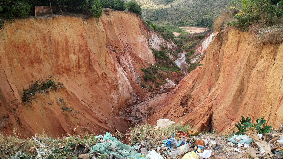
During research in Buriticupu, Maranhão, in 2015 and 2016, geographer Marcelino Silva Farias Filho of the Federal University of Maranhão counted at least 15 giant chasms tearing the ground apart in urban areas of the municipality. He and his students also heard reports from residents whose houses had been swallowed by gullies, a phenomenon in which rainwater carves large gorges through fragile soils until it reaches the water table. Depending on the volume of water and geological conditions, gullies can expand rapidly.
Houses on the hillsides in the neighborhoods of Santos Dumont, Vila Isaías, and Caeminha were all at risk of landslides. Many residents who faced losing their homes were relocated from other parts of the city threatened by gullies. “After we completed the study, we contacted the local authorities to warn them that the situation was going to get worse, but they paid us no attention,” he says. It got worse.
On March 24, 2023, after heavy rainfall, the Maranhão State Prosecutor brought proceedings against the municipality for failing to comply with an April 2022 court agreement to implement a series of measures aimed at preventing further erosion and ensuring the safety of residents in at-risk areas. On March 26, the municipal government declared a state of public emergency due to 23 gullies that reached 70 meters (m) deep and 600 m long, threatening 880 people in 220 houses on the slopes of the town. Two days later, the Ministry of Integration and Regional Development recognized the state of emergency.
These gorges, deepened by heavy rainfall, are not exclusive to the state of Maranhão. Gullies are formed in urban and rural areas nationwide across Brazil. In the state of São Paulo, a report by the Technological Research Institute (IPT), presented at a conference in Natal, Rio Grande do Norte, in 2015, identified 1,398 erosive processes in the urban areas of 326 municipalities, of which 949 were classified as gullies and 449 as ravines—the term used in Brazil for an eroded channel deeper than 1 meter (m) that could evolve into a gully.
In the rural areas of São Paulo, 39,864 erosive processes were recorded in 593 municipalities, of which 30,004 were classified as gullies and 9,860 as ravines. According to the study, the high number of gullies in urban areas indicates inadequate forms of soil occupation and drainage, and in rural areas, suggests agriculture is not making appropriate use of soil and native vegetation conservation techniques.
The conditions that lead to the formation of gullies vary according to the location, soil type, incline, and rainfall volumes. They usually start as smaller channels, which evolve into ravines and then gullies.
“If rainwater falls in a concentrated manner at a greater speed than the ground can support due to deforestation and improper land use, the erosion process begins,” explains Claudio Luiz Ridente Gomes, an expert in civil construction technologies and one of the authors of the IPT report.
According to two articles published by Farias Filho in the journals GeoUECE and Geografia em Atos in January and March 2019 respectively, urban gullies in Buriticupu are caused by a combination of factors linked to natural conditions and human occupation, including fragile geology with nutrient-poor soils susceptible to erosion and formed on less resistant sedimentary rocks; intense rainfall (defined as more than 2,000 liters per square meter per year); and urbanization without proper planning and rainwater drainage. The researcher says there are reports of areas in the region having been affected for more than 50 years.
According to the Geografia em Atos article, the municipality’s soil is acidic (with a pH of around 4), a common characteristic in tropical regions, and has low levels of aluminum, which would help to aggregate sediments, and a high concentration of hydrogen, which leads to increased dispersal, promoting erosion. On the hillsides, the terrain is more irregular and highly uneven.
In recent years, the city has grown in a disorderly fashion towards the edges of the plateau where the municipality originated. “The streets function like channels that direct water towards the edges of the plateau, opening and expanding the gullies,” explains Farias Filho.
Many of the hillsides are classified as Permanent Preservation Areas (PPAs) by the Brazilian Forestry Code and should therefore be protected, emphasizes the GeoUECE article. The researcher says that in 2022, the municipal authorities invited him to meet with a working group and study how to stop the advance of the gullies. “I presented the results of our research in May 2022, but I never found out whether the town’s work had progressed,” he reports. When asked about the meeting and resulting actions, the town hall did not comment. In a statement to Pesquisa FAPESP, the state government reported that the Maranhão Fire Department, “participated in an operation to close off the area of risk and relocate families living there as a priority measure.”
There were other warnings: in two studies from 2014 and 2018, the Geological Survey of Brazil (SGB) highlighted the risk of expanding gullies in Buriticupu and estimated that approximately 1,400 people lived in 10 locations identified as of high geological risk.
Diverting the rain
To reduce the growth of gullies, Farias Filho says the flow of rainwater needs to be channeled, at-risk areas closed off, residents relocated, and works carried out to direct water from the streets to lower areas on the outskirts of the town.
Jurandyr Ross (see Pesquisa FAPESP issue no. 302), a geographer from the University of São Paulo (USP) who has studied gullies in other regions of the country, adds: “There are many engineering techniques for containing rainwater, but they are expensive.” Storage tanks, for example, can temporarily store rainwater, reduce its speed, and then direct it to a river or stream through drainage channels.
Channeling alone could be insufficient, since the water does not always flow to the desired location. “One of the major problems with pluvial systems is that many end halfway, without actually reaching a watercourse,” says Antônio Vieira, a geographer from the Federal University of Amazonas (UFAM). “In the mid-1990s, in a housing complex in the north of Manaus, water was diverted away from a gully toward the other side of the same slope. The result: two new gullies emerged there.”
In an article published in the journal Revista do Instituto de Geociências–USP in December 2022, Vieira described three gullies in the urban area of Rio Preto da Eva, a town about 80 kilometers (km) northeast of Manaus. Because the soil was clayey and more resistant to erosion, he attributed the chasms to urban expansion and consequent rainwater drainage problems. From July 2019 to July 2021, the largest of them increased from 116 m in length to 127 m and from 17.9 m in depth to 22.9 m. “At least two houses are at risk of being swallowed,” he warns.
The three gullies caused the loss of a total area of 6,117.2 square meters (m2) and 123,267.29 cubic meters (m3) of soil, which accumulated in nearby channels, according to the study. The cost of the damage adds up to around R$170,000 and containment measures would cost nearly R$2 million. “It’s cheaper to monitor risks and prevent problems before they occur. The sooner the damage is contained, the better,” stresses Vieira. He also found gullies close to highways that link Manaus to the interior of the state.
There are almost 100 of them in the Palmital creek basin between the towns of Nazareno and Conceição da Barra in the south of the state of Minas Gerais, and many are interconnected, according to a March 2020 article in the scientific journal Catena. The recovery of a single gully may not, therefore, be enough to stop the erosion process.
“Through subsurface and surface water, one gully can interfere with the others, like a cascading effect,” explains geologist Valéria Rodrigues of the São Carlos School of Engineering at the University of São Paulo (EESC-USP), coauthor of the paper. “For this reason, when thinking about containment and mitigation, the gullies need to be looked at as a whole. Otherwise, if you deal with just one of them, the erosive process is likely to continue.”
Aluísio Andrade, an agricultural engineer from the Brazilian Agricultural Research Corporation (EMBRAPA), agrees: “The first step is to study the region and diagnose the erosion process, then to draw up a customized plan.” A combination of mechanical practices—such as soil reallocation, containment, and drainage—and vegetation cover can be implemented, depending on the case.
EMBRAPA used this approach for a gully in Morro do Radar, close to the Galeão International Airport in Rio de Janeiro. As described in a statement issued by the company in December 2005, the first step was to build terraces on the hill, diverting the water and preventing it from flowing into the gully. Leveling of the terraces corrected the slope and allowed the land to then be reoccupied with fast-growing tree species, such as maricá (Mimosa bimucronata), which can grow 10 m tall, and sabiá (Mimosa caesalpiniifolia), which reaches up to 8 m and is widely used in the recovery of degraded areas.
“Depending on the soil, climatic conditions, and size of the area, what works for one gully may not work for another,” emphasizes Andrade. Rodrigues supports this point: “Every region has its own particularities. There are no ready-made formulas for dealing with gullies, but monitoring, land use planning, and correct water drainage are always essential.”
Scientific articles
ALMEIDA FILHO, G. S. de et al. Processos erosivos lineares no estado de São Paulo. XXXV Brazilian Congress of Soil Science. Natal, RN. Aug. 2015.
ANDRADE, A. G. de et al. Práticas mecânicas e vegetativas para controle de voçorocas. Comunicado Técnico. Vol. 33, 2005.
FILHO, M. S. F. et. al. Processos erosivos urbanos e a qualidade dos corpos hídricos em Buriticupu, Maranhão. Revista Geografia em Atos. Vol. 2, no. 9. Mar. 2019.
MACEDO, L. T. S. et al. Mapeamento de voçorocas e do risco de erosão em área urbana no oeste do estado do Maranhão. Revista GeoUECE. Vol. 8, no. 14. Jan. 2019.
REAL, L. S. C. et al. Proposition for a new classification of gully erosion using multifractal and lacunarity analysis: A complex of gullies in the Palmital stream watershed, Minas Gerais (Brazil). Catena. Vol. 186. Mar. 2020.
VIEIRA, A. F. S. G. et al. Caracterização das voçorocas da área urbana de Rio Preto da Eva (AM), Norte do Brasil. Revista do Instituto de Geociências – USP. Vol. 22, no. 4. Dec. 2022.
Republish